March 4, 2025 |
Keith Cooke | Infrastructure
December 2, 2025
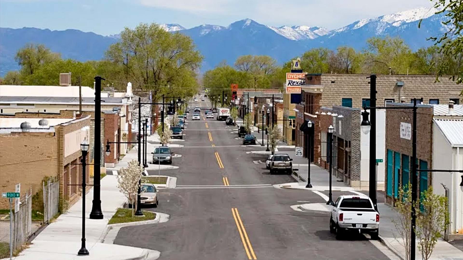
Main Street once defined the American city. Tight rows of busy storefronts, bustling civic centers, and gathering spaces provided jobs, tax revenue, and community character. Today’s downtowns tell a different story: empty buildings, declining tax revenue, and poor land management.
But many city planners aren’t accepting decline. They’re using geographic information systems (GIS) technology to model every building, street, and parcel in 3D—then testing scenarios before committing resources. This precision lets them identify where investment will work, what needs to be preserved, and how new development fits with existing character. The result: they’re boosting the local economy, building community, and preserving cultural identity. These new urban business models have other benefits: curbing suburban sprawl, improving air quality, and protecting farmland and other green space in and around our cities.
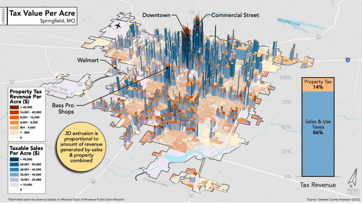
Across the nation, this approach is turning faded downtowns into standout destinations. Once transformed, a city’s downtown can generate more tax revenue than any other neighborhood in the municipality. That boost to the treasury helps cities pay the cost of delivering services residents expect in every part of town, including police, fire, and water. And more communities are taking notice, shaping their own investment strategies by borrowing ideas from the most promising locations.
To maximize every parcel of city land, planners need precise landscape data and detailed knowledge of its features. This requires volumes of hyperlocal location data. Interactive digital maps and 3D models—powered by GIS technology—organize the data in layers and present it in the context of its location.
This virtual environment provides a view for imagining what is possible. With GIS maps and models, collaborators can test ideas, forecast outcomes, build consensus, smooth out obstacles, and address risks before a single foundation is built.
Through these processes, communities become more innovative. For instance, housing for growing populations and a need for diverse tax revenue streams are common challenges across US communities—issues now addressed virtually first using GIS.
This collaborative approach is helping communities celebrate their history and traditions. The approach helps communities protect regional identity while planning for growth.
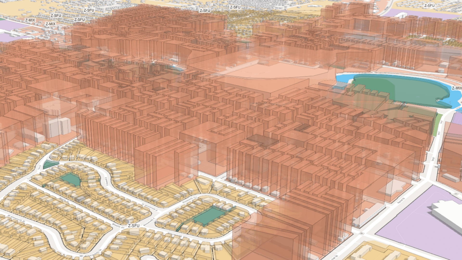
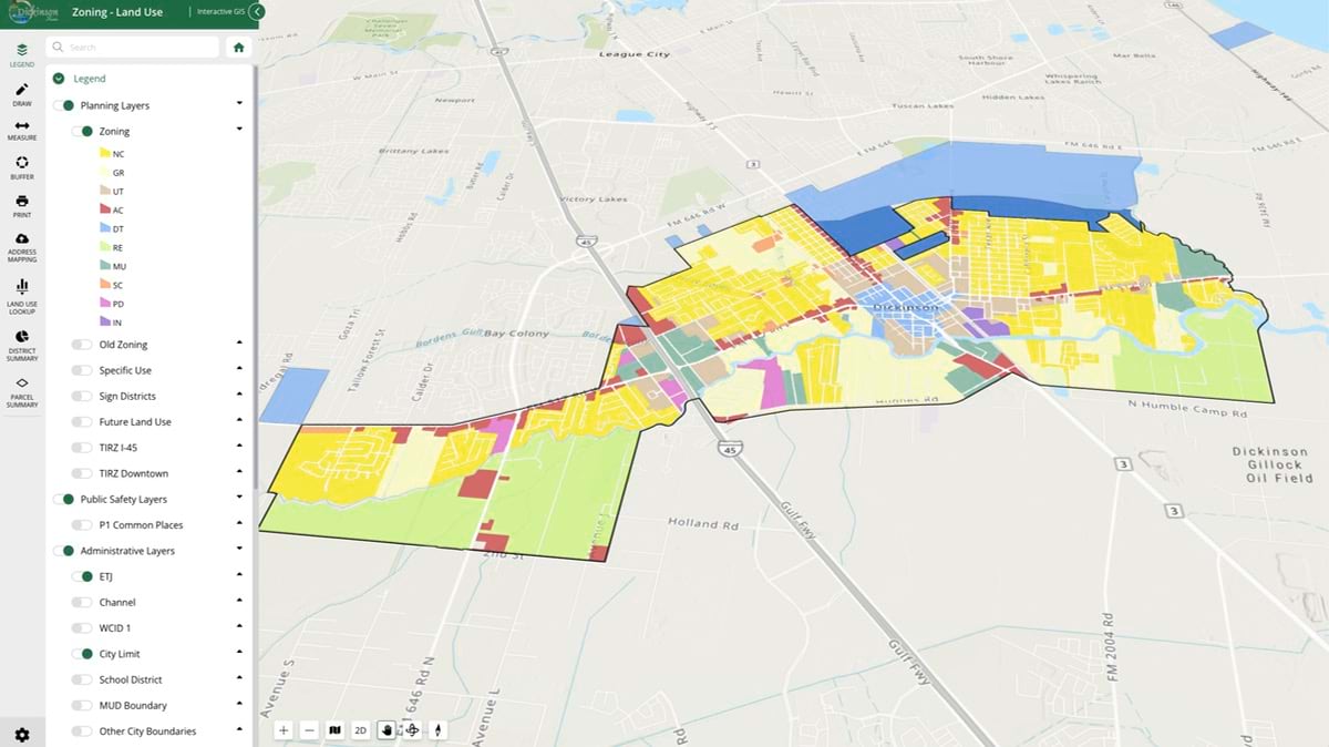
Dickinson, Texas, is one of many cities revitalizing its downtown in part to meet growing demand for housing. The city, 30 miles south of Houston, covers just 10 square miles and is surrounded by other cities, leaving no room to expand outward. So, Dickinson is building up.
Planners built the city’s first digital twin—a virtual 3D GIS model of their plan for transforming 12 blocks. The new compact, mixed-use community will hold 200–400 apartments that have retail space on the first floor, along with some semidetached townhomes.
Designed for walkability and long-term resilience, the neighborhood will have one parking space per 2,000 square feet of built space. With more pedestrian and cycling paths, planners expect cars to become less of a necessity.
“We can’t have the suburban sprawl growth,” said Theo Melancon, Dickinson’s city manager. “But we can have something with much more impact per square foot on the property that we do have.”
Planners anticipated skepticism from developers and city council. But the digital twin allows city leaders to model design concepts; forecast tax revenue; and show all stakeholders what a denser, more walkable community would look like.
Potential investors in Texas “have no experience with this kind of development,” Melancon said. “But when you can show a broader picture of what downtown could be, what we’re committed to doing over several city blocks, they realize every parcel is part of a bigger picture.”
Greenville, South Carolina, is recognized for modernizing its downtown while holding onto its local color. As its stature grows, the city is welcoming more newcomers and employers and seeing its job market grow. Ninety-seven percent of class A office space downtown is leased, and urban planners travel from across the South to visit, with hopes of finding ideas to borrow.
A breathtaking riverfront park with a waterfall and a sky bridge for taking in the scenes are centerpieces of downtown redevelopment and a large part of what now makes the city recognizable. The streets are lined with stately hotels, as well as shops and restaurants where visitors can experience the city’s Southern charm.
Today, Greenville’s leaders say it’s time to seek balance. As the inventory of undeveloped downtown land shrinks, land and housing prices are rising. That could limit future redevelopment and affordability.
Planners believe it will take just as much focus—with GIS essential for gathering location-specific business intelligence—to manage future development in a way that continues to make it a top place to live, work, and enjoy diversions. City officials hope to preserve as much as 35 percent of the city’s vacant land as open space and 10 percent for new affordable housing units.
“We built a matrix, and we used a lot of our GIS software and mapping to identify all the parcels that are undeveloped and then look at their potential for development,” said Edward Kinney, manager of the city’s Preservation and Urban Design Division. “If a parcel that we haven’t been thinking of suddenly becomes available, we run it through that matrix in order to determine whether or not it would be valuable for us to pursue.”
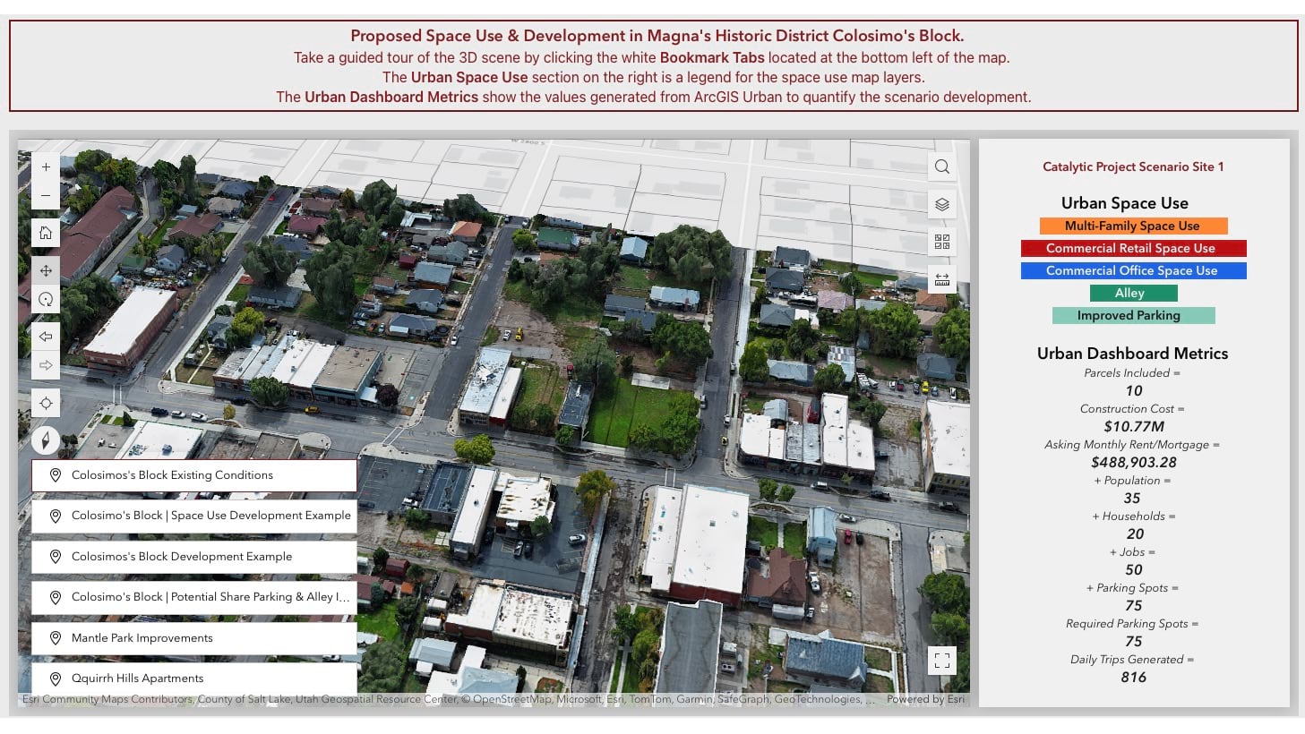
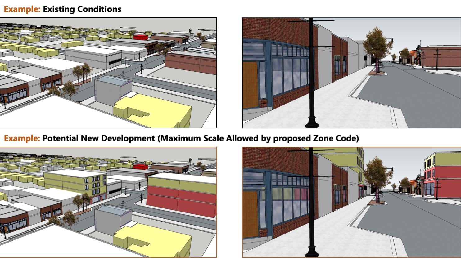
Located on the western edge of Salt Lake County, Magna, Utah, was once a copper boomtown with stately brick buildings and Victorian homes. Over time, its core faded—damaged by a 2020 earthquake and decades of car-centric development.
Today, planners are using GIS to preserve the town’s cultural identity while shaping a more walkable, community-centered future. Using drone imagery inside GIS, they created a digital twin of the downtown area, including Copper Park and the local library. The immersive 3D model sparks community conversations about zoning and design.
“Rather than speaking indirectly about concepts, such as maximum building heights, we could show them,” said Marie Schleicher, GIS analyst at the Greater Salt Lake Municipal Services District.
The digital twin also supported Magna’s successful bid to add its downtown to the National Register of Historic Places, unlocking tax incentives and rehabilitation funds. Planners used GIS to model mixed-use development—retail on the ground floor, apartments above—that would complement the area’s historic feel while addressing Utah’s housing gap. They evaluated retail space, housing needs, and public amenities to ensure that the growth aligned with community values.
The result is a revitalization strategy rooted in stewardship—preserving Magna’s history and culture while creating a walkable downtown designed to serve residents into the future.
People still are drawn to their Main Street. But modern life imposes new realities, including population growth that requires tighter, denser development and better protection of open space. This means building world-class cities of the future requires new strategies for land use in the commercial core.
Cities are embracing the challenge. They are updating zoning regulations, embracing mixed-use development, and designing for walkability. And many communities are seeing their downtowns once again becoming the lively, economically vibrant destinations that keep people coming back. Only now, those areas are also more becoming resilient and future ready.
Learn more about how planners use GIS to evaluate zoning, land use, and development scenarios.