
February 22, 2018 |
June 6, 2018
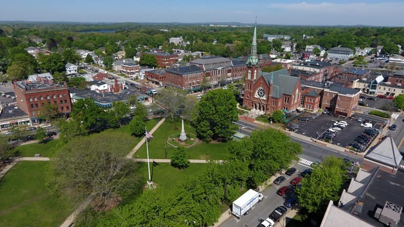
In October 2016, the town of Natick, Massachusetts added a drone to their Geographic Information System (GIS) division within the Public Works department. The small airborne sensing platform immediately fulfilled its initial purpose of faster and safer infrastructure inspections, providing a quick return on investment. Additional departments took notice and came up with more innovative ways to use the drone to improve the town. Each town department, from the police to public schools, has benefited from the new approach, improving awareness, aiding planning and design, ensuring public safety, improving operational efficiency, and saving tax dollars.
Inspection Safety
The impetus for purchasing the drone was to improve the efficiency and safety of workers inspecting Natick’s two water tanks. Massachusetts Department of Environmental Protection (MassDEP) requires monthly inspections of all tanks in the state, a process that required workers in Natick to ascend a ladder to make sure that access points at the top of the tank were secure. The use of the drone allowed Natick to eliminate workers’ exposure to this hazardous task.
“Every month that our staff doesn’t have to scale a twenty-foot ladder to look at a hatch is a win,” said Anthony Comeau, supervisor of Natick’s Water Division.
In the past, Natick sent a pair of inspectors who would take a full morning to climb and record each inspection. With the drone, the tank inspection requires just one drone pilot, and the process now takes less than an hour. In addition to the time savings, the high-resolution imagery meets the consistency standards required by MassDEP, improves the level of detail that the inspections capture, and keeps employees safe.

Drone Imagery Meets Mapping
The GIS division suggested the drone program as a natural fit to supplement their existing workflows. GIS users have long used imagery to inform mapping, and drones are being adopted quickly by these technologists due to their low cost and flexibility. GIS provides the tools to process drone imagery and insert this new data into the town’s map. It also catalogs each individual image in order to report inspections and provides the means to analyze change over time.
Drones complement professional aerial surveys rather than replace them. While a drone is far more nimble and less expensive, it doesn’t have the flying time and range to capture and map the whole town quickly. Instead, it’s ideal for project-based work.
“This drone program isn’t capable of replacing our five-year town-wide imagery procurement schedule,” said Richard Ames, GIS Coordinator for Natick. “However, it is indispensable in enhancing the timeliness of our GIS mapping updates.”
Improving Infrastructure
When a new housing subdivision was built in Natick, a quick flyover of the construction site captured imagery of the town’s new addition. Previously this update of official records would have been delayed for years until the town’s next aerial imaging survey. Instead, digital maps and records were instantly updated.
The rapid update of the town map benefits all departments. Emergency services are certain to find the new homes, town records on the new properties will align with the map, and the map record will reconcile any changes between what was designed and what was built.
Next, the GIS team used the drone to help plan a new parking lot. They flew the drone high enough to capture the entire lot in one image, then used GIS software to apply a process called georeferencing. This process associates each part of an image with its relevant map coordinates to create an accurate digital representation of the area. They then designed potential parking layouts, visualizing various scenarios. Seeing the layouts on a map gave planners instant insight that helped them to choose the one that worked best. The winning plan informed construction, providing plans for paving and painting lines.
The GIS division has also used the drone to document the installation of sewer projects, recording images of the open trench that clearly show where gas lines and other infrastructure elements intersect.
“The drone flights over recently completed construction projects preserve the actual trench locations in a reproducible and measurable format,” said William E. McDowell, the town engineer. “This is incredibly valuable because once the street is paved these trench locations are lost.”
When the town implemented a state-sponsored solar power program, the GIS team documented the process with the drone. They took aerial photos of each installation, sharing the scope and progress by plotting each individual project on a community map.
“From a practical perspective, the images were helpful in confirming the arrays and conduit were installed as designed,” said Jillian Wilson-Martin, the town’s sustainability coordinator. “Students at Lilja Elementary School were excited and proud to have their aerial photos taken in conjunction with their building’s new solar arrays. I think a few aspiring drone pilots were born that day!”

Ascending Applications
As use of the drone expanded, the GIS division streamlined the data collection and data sharing process to perform more functions for more town departments. Police, schools, planning, conservation, engineering, and public works departments have all requested fresh drone imagery for their projects.
Natick Public Safety recently purchased a drone with enhanced low light and thermal imaging capabilities. Thermal imaging picks up heat signatures, which can be used to discover people lost or hiding in the dark. This drone will assist in police work, protecting citizens and potentially saving lives in search and rescue operations.
The town’s drone has mapped the health of turf grass across Natick, broadcasted a live feed of the Boston Marathon as it passed through the town, and an aerial image captured by the drone provides the background for the town’s website and the cover of the town’s annual report. To accommodate the growing demand, the town plans to train and license additional drone pilots.
The drone has also drawn the interest of citizens.
“During field operations, residents often inquire about what I am doing with the drone,” Ames said. “I have received nothing but positive comments after explaining the program.”
Learn more about what you can do with Drone2Map for ArcGIS.

February 22, 2018 |

January 11, 2018 |
September 27, 2017 |