
February 2, 2023 |
Patricia Cummens | Infrastructure
March 7, 2023
When Agriculture Secretary Tom Vilsack visited North Carolina in 2022 to announce a $17.5 million grant for broadband connectivity, it felt like a lottery win for Warren County officials. Without the vital internet connections that drive economic centers, the predominantly Black rural community of fewer than 19,000 people was languishing.
Digital maps and data science are guiding these types of decisions, determining which communities get grants and loans for broadband. The work centers on identifying disconnected communities as part of a historic effort to strengthen economies and improve equity by bringing high-speed internet to America’s most marginalized households.
“As a small rural county, it’s hard to imagine what our future would be without broadband,” said Vincent Jones, Warren County manager. “We would have to consider taking on a multimillion-dollar debt to almost fully subsidize a private company to build a network here or forgo making improvements to our schools because, at this point, broadband is considered a utility, just like electricity.”
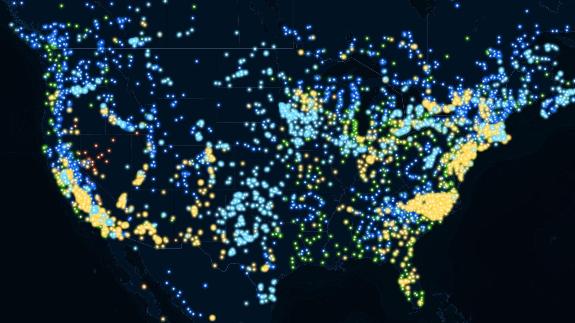
With tens of billions of dollars in federal broadband development grants and loans available, states like North Carolina rely on geographic information system (GIS) technology to map needs in their communities. The maps make gaps in connectivity more visible and new levels of collaboration possible.
The North Carolina Department of Information Technology (NCDIT), for example, is following prescribed steps to challenge what many consider to be a fuzzy view of existing broadband networks in the state. NCDIT’s maps will show service levels in the state and spotlight locations that lack adequate or affordable broadband, deepening an understanding of the digital divide. The work will help refine the federal government’s National Broadband Map, used to determine eligibility for grants and loans.
Warren County sits on the Virginia state line about 55 miles northeast of Raleigh, the state capital. Its location and other assets could help the county grow, diversify, and shed its legacy of a higher-than-average poverty rate. With growth in Raleigh and in the two other cities of the prosperous Research Triangle region spilling over into the surrounding area, officials in Warren County hope to capture that momentum.
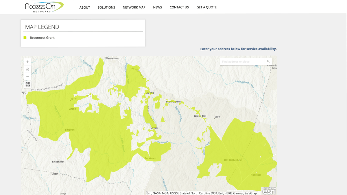
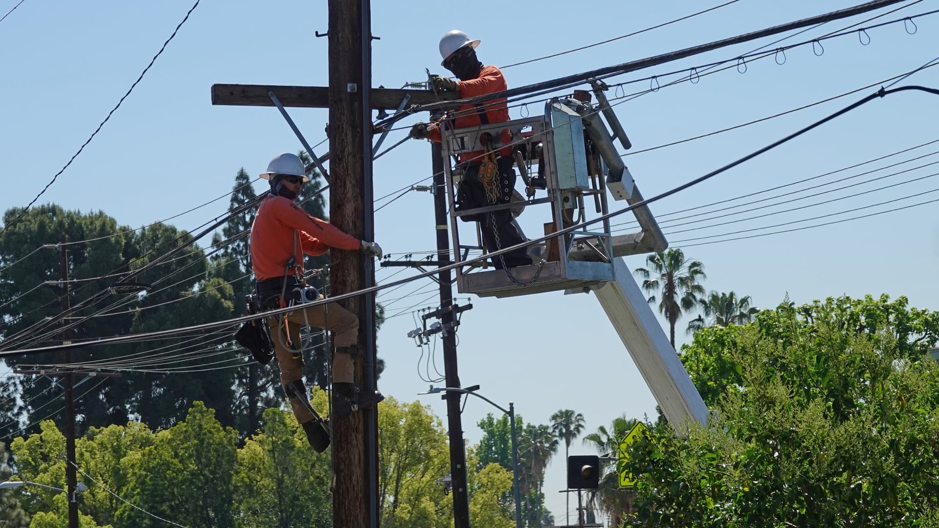
Local officials have worked for years to find an internet service provider (ISP) to help boost the county’s appeal, but requests for proposals have been unsuccessful. With the US Department of Agriculture (USDA) ReConnect grant, the county now has two ISPs, including AccessOn Networks, that are making plans to connect homes and businesses in the years ahead.
Warren County has fought for fairness before. In 1982, the county became the birthplace of the environmental justice movement when protests erupted because the state decided to locate a toxic waste dump in the county. The state prevailed, however, and contaminated soil continues to make agriculture—one of the county’s top-five industries—challenging for some growers.
Black farmers have also incurred losses because of predatory and discriminatory USDA lending policies that caused families across the US to lose an estimated $326 billion in land in the 20th century. Those policies led to generational disenfranchisement and poverty among African Americans, relegating many to sharecropping on leased land or forcing them into other professions.
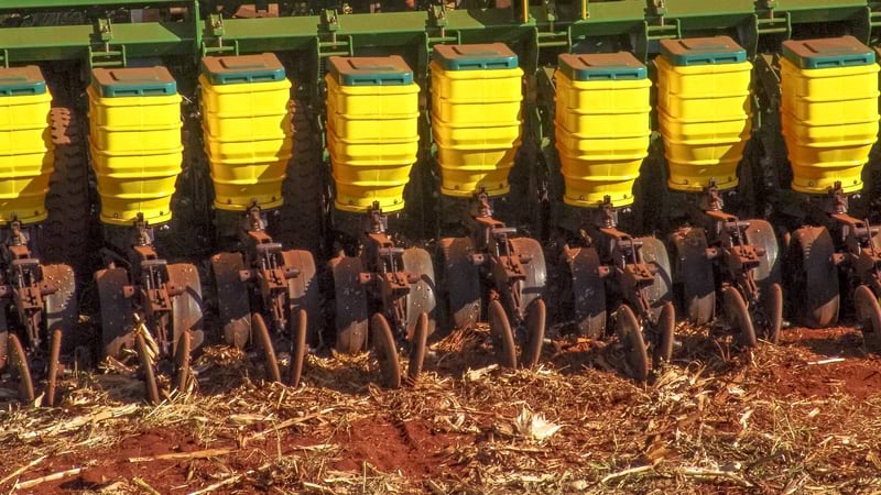
Demetrius Hunter, founder of The Black Farmers Hub, comes from a family that lost land and opportunity because of predatory lending. Today, unstable internet connections cause his computer to crash and calls to drop, hindering critical business tasks. Hunter often drives to the library to submit forms required for loans. When he needs to send images of his family’s farmland for grant applications, he might have to rely on a hot spot on his phone to connect with the drone. Even that tactic is unreliable.
Hunter says he hopes that he and other farmers in his area can move toward modernization in an industry increasingly driven by technology.
“We want to appeal to younger generations, and we can’t appeal to them if they don’t have technology,” Hunter said. “That is the way to make farming attractive.”
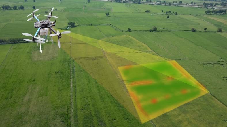
Large agricultural operations use satellite or drone imagery with GIS to manage and monitor crops, and they automate many manual tasks. However, this technology-driven approach requires fast, stable internet connections to communicate between sensors, devices, and the wider world. For Hunter and other farmers in the region, even video calls are beyond available bandwidth.
Warren County’s USDA ReConnect grant promises more freedom to modernize—if their addresses appear on broadband eligibility maps used for awarding development funds.
The Federal Communications Commission (FCC) reported in 2020 that more than 85 percent of Americans have access to broadband but that figure is disputed by many people with slow or nonexistent connections. In the digital divide, an estimated 30 million Americans are disconnected from services and opportunities. This is because larger ISPs often avoid areas where the cost of extending service would be greater than the market’s potential to generate revenue.
Taking a stand to boost rural prosperity through connectivity, the White House and Congress put forth $65 billion for broadband development through the bipartisan Infrastructure Investment and Jobs Act. The legislation builds on billions of dollars for broadband deployment in the American Rescue Plan. Together, these once-in-a-generation investments are intended to ensure that every American has access to high-speed internet for education, health care, job searches, and other opportunities.
Internet service providers that win broadband development grants or loans for work in underserved areas are often smaller operations. These organizations face an ambitious requirement of building facilities capable of providing internet speeds of 100 Mbps (download and upload) to every location in their respective service areas. Creating accurate maps that delineate disconnected locations and people is an essential step for expansion.
“You really don’t know where that line is,” said Ben Shelton, project manager for the North Carolina Center for Geographic Information and Analysis (CGIA). “As we’re getting these stronger datasets, it’s becoming possible for us to hone in on locations that have a lack of service. We’re still at regional scales without getting down to the street, household, and business levels that are needed.”
For Shelton and his colleagues, the work to identify gaps includes validating maps and data that ISPs submit to the FCC for the National Broadband Map and to programs that offer broadband development funds. ISP maps define the reach of a company’s existing and proposed broadband networks. The North Carolina CGIA provides analysis to help verify who is and isn’t served.
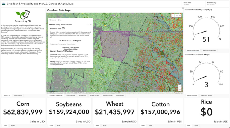
The state’s online mapping tool for the Growing Rural Economies with Access to Technology grant program, or NC GREAT, helps ISPs understand and evaluate markets. Map layers include addresses and parcel boundaries, community survey responses, federal broadband grant award areas, and US Census blocks with broadband surveys reporting substandard internet service.
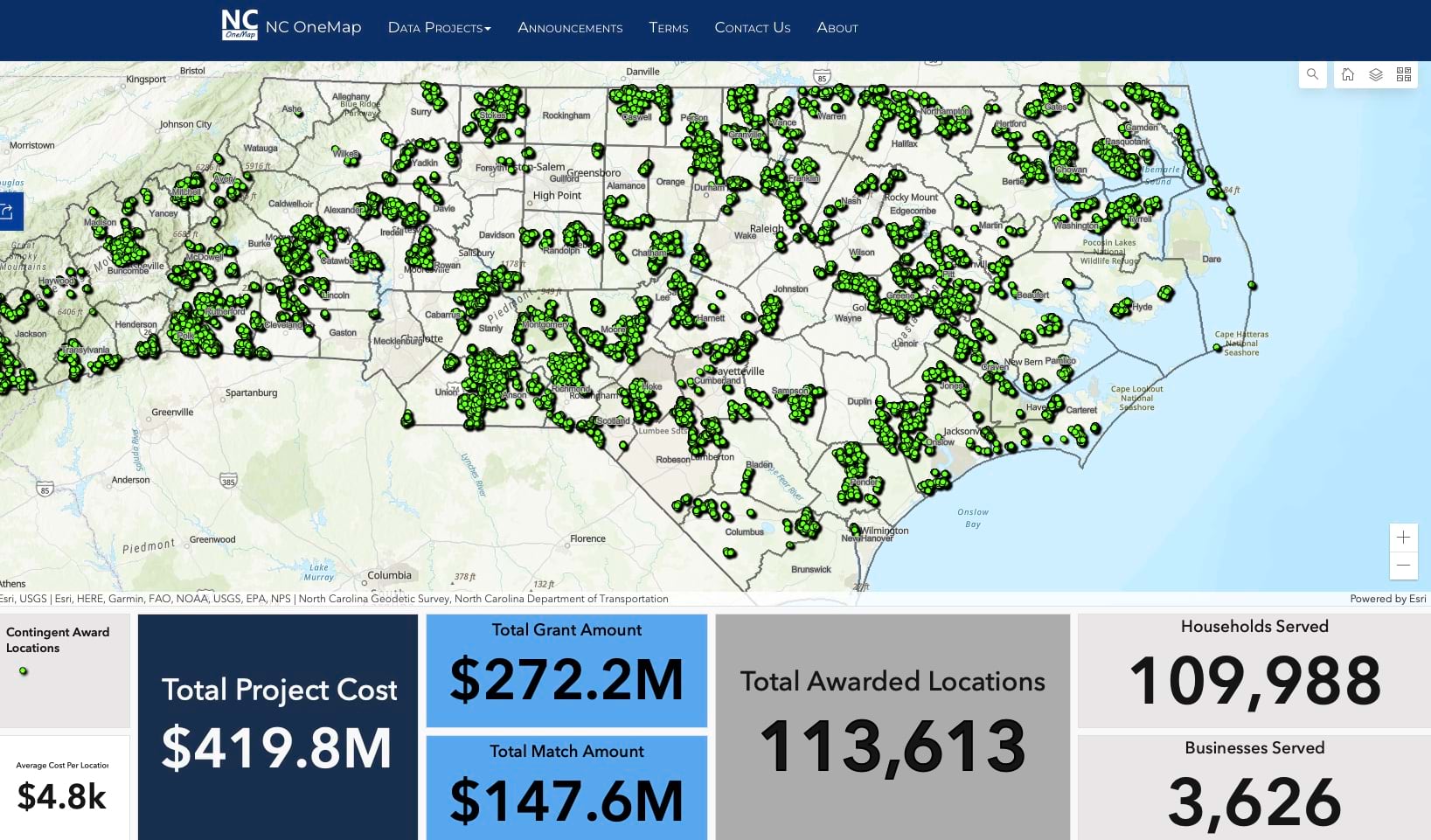
These maps also allow ISPs and government agencies to detect discrepancies or evaluate proposed or ongoing changes. Analysts can compare FCC and ISP data and map the results of individual broadband speed tests by location. Such authoritative data refines the state’s broadband map, which stakeholders can use to challenge the National Broadband Map.
“It’s still going to take three to five years or longer to get all of this into the communities and built out because it’s just such a magnitude of funding coming down for broadband,” Shelton said. “We have maybe the next year or two before all the funds have been committed. You don’t want to get to the end of the cycle and then have the clarity of hindsight. It’s a very critical stage right now.”
This stage is critical for the region’s farmers as well. It’s a situation that those who devote their lives to agriculture in large and small communities understand perhaps better than most. To help feed a global population, farmers need access to the best resources. In Warren County, farmers in The Black Farmers Hub can check network availability maps from AccessOn Networks and other approved ISPs. The hub’s maps will tell them whether approved grants and loans will bring high-speed internet to their addresses.
These broadband grants and projects offer hope to deserving households and businesses to close the equity gap for rural communities.
Learn more about how GIS addresses community vulnerabilities and helps guide telecommunications build capacity to conduct more efficient operations.