It’s a tale of two Americas: those who have high-speed Internet access, and those who lack it.
The 24 million residents cut off from broadband connectivity inhabit a more isolated world where disadvantages accrue on many fronts: children struggle to complete homework or engage in remote learning, while seniors are unable to connect with caregivers through telehealth. Rural farmers on the wrong side of the digital divide fall behind their technologically advanced counterparts, who save time and resources by leveraging precision agriculture.
In the Infrastructure Investment and Jobs Act (IIJA) passed last year, Congress earmarked $42.45 billion to close this gap and make broadband internet access more equitable. Funneled through the states, this money will fund telecommunications companies’ efforts to establish broadband connections in areas of the country overlooked by 21st century progress.
Telecoms taking part in this effort will need to employ the latest digital tools, like geographic information system (GIS) technology, to ensure that they efficiently and profitably expand internet access across the country.
Some industry experts have characterized the initiative as a digital version of the 1950s-era Interstate Highway System—a huge public investment in nationwide connectivity. As telecommunications companies seek to capitalize on the massive pool of funding, location will play a crucial role in each stage of planning and buildout (see sidebar below).
The insight born of GIS, known as location intelligence, is poised to empower business leaders to maximize what may be a once-in-a-generation opportunity to deliver internet access across the country.
Spatial Awareness: The Key to Expanding Internet Access
The expense of building out broadband networks is just one challenge telecoms face. Others include understanding which communities already have internet access, and ensuring that the buildout is well-planned and coordinated.
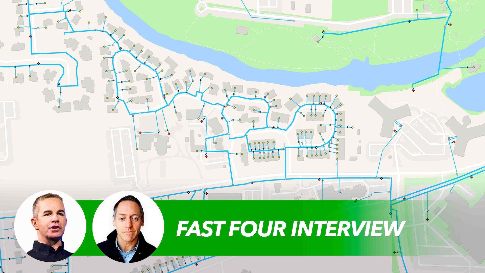
By unifying real-time maps of network assets with data on potential possible customers and markets, GIS helps telecom decision-makers overcome key hurdles and prepare for the broadband expansion push.
In this critical planning stage before IIJA funds are distributed, many executives are employing spatial analysis to map their current network against unserved or underserved areas. While government funding will subsidize the build-out—each state will receive at least $100 million—telecom carriers will be on the hook to maintain service going forward. Without location intelligence, executives can’t project their return on investment. By using the data science in GIS to analyze variables like demographics, terrain, drive times, and labor availability, internet service providers (ISPs) pinpoint neighborhoods where they’re able to offer broadband access to the highest number of customers, profitably.
In the execution phase, spatial awareness will provide crucial advantages as well. Geospatial dashboards create a centralized platform for sharing insights and facilitating collaboration among executives, state-level decision-makers, and community stakeholders. By reducing inefficiencies and communication lags, GIS accelerates approval and permitting processes, and streamlines workflows that stretch from construction-material supply chains to teams operating in the field.
Some analysts expect this may be the last major government-led effort to expand broadband internet access in the US. Location intelligence will be indispensable to creating the strategic roadmap needed to build connectivity from coast to coast.

GIS-based smart maps enable business leaders to carry out what-if planning by modeling data visually and forecasting subscriber trends based on past performance.
Understanding the Network Before Taking Action
Savvy telecom leaders will make a series of calculations before they even apply for IIJA funds. With location technology collating data from disparate sources, they can achieve understanding before taking action.
Executives at many internet and cable companies enlarged by mergers and acquisitions lack transparency on the full breadth of their network. Information is often siloed in email servers and CAD files, on paper maps, or even in employees’ memories.
With GIS, companies create real-time service maps, accurate down to individual homes and businesses on the network. By toggling on various data layers, executives can gain a holistic picture of how efficiently and profitably they can extend high-speed services to each neighborhood.
If IIJA money covers only half the cost of building fiber to reach a community, does it make financial sense for the company to fund the rest? Will projected five-year returns cover the costs of maintaining and repairing fiber optic cable in a remote location?
Geospatial intelligence gives telecom executives the means to answer these questions. Business leaders can scenario-plan with smart maps and 3D models, testing variables like truck rolls (the time and distance associated with field service calls), market penetration, or construction timelines to forecast which network extensions are most viable, and which the company should bid on.
Seeing Opportunities—and Red Flags—Through the Lens of Location
With a GIS-based digital twin of network assets and operations, leaders can anticipate KPIs for new service areas.
For instance, maintenance technicians are often evaluated on mean time to repair (MTTR)—the amount of time it takes them to resolve an issue after a complaint comes in.
If a company has committed to an MTTR of two hours, GIS analysts can use a drive-time analysis to determine whether technicians can reach a target neighborhood fast enough. If it’s a 90-minute drive, the company might have to consider hiring maintenance workers closer to the underserved area, or even building a new facility.
Business leaders must monitor other variables that influence operations but which might be difficult to discern from a simple property map. If construction will involve digging underground to lay fiber optic cable, for example, a provider might want to switch on a map layer of soil types. The presence of granite boulders beneath the surface could be the difference between an operation that costs $7 a mile and one that costs $100 a mile.
Finding the Right Customers for Broadband Internet Access
Since the goal of the broadband equity program is to expand internet access to the highest number of underserved people, companies need to allocate resources for the greatest possible impact.
By interweaving GIS data on population, demographics, and even behavioral habits like media consumption, telecom executives can narrow investment targets to the towns and areas likeliest to offer the highest broadband engagement.
A single home in a remote mountain area is unlikely to justify the expense and infrastructure needed to build to it. Alternately, a survey might reveal that residents in a rural area do not actually want broadband, and are content to access the internet through mobile devices. Expanding to these areas—as opposed to places where schools or hospitals indicate higher broadband demand—could end up squandering public and private resources.
Collaboration for a Nationwide Effort
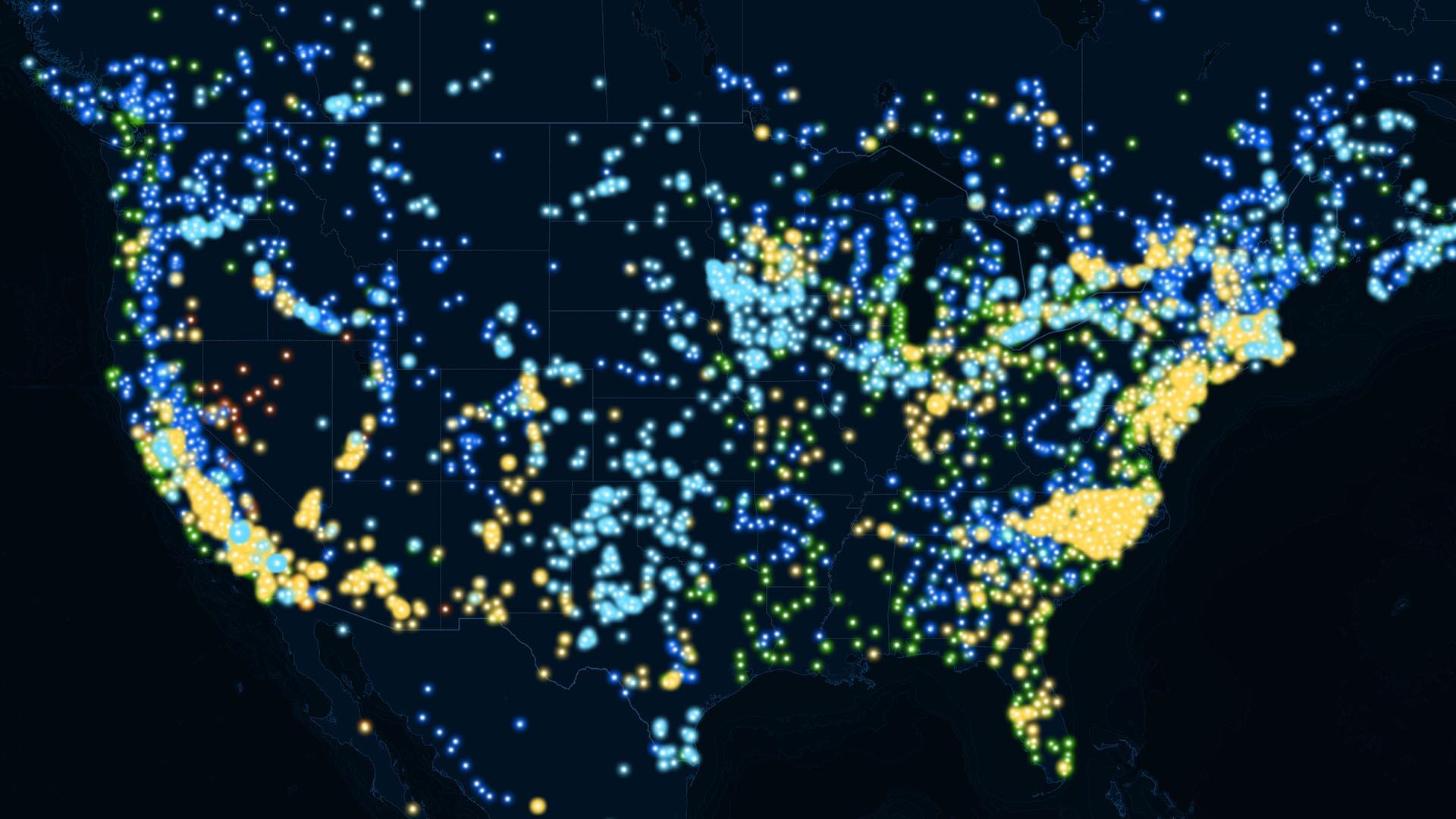
Maps will serve as the common language between the federal government, states, and companies as they determine how IIJA funds are disbursed. Each state will receive $100 million as a baseline; from there, state officials will apportion money based on severity of need. The Federal Communications Commission (FCC) is creating a national broadband map intended to identify every property in the US that might require reliable internet access.
Once the FCC’s version is available, telecom companies will ground-truth the information by identifying which areas their networks serve. Through this process, the FCC will gain a more accurate picture of the country’s digital divide than they’ve ever had, as previous methods frequently overestimated the breadth of broadband service.
Companies that can effectively use maps to communicate with state officials and speed the decision-making process will have a significant advantage over competitors. A business that’s able to quickly analyze project areas, bid on the best opportunities, line up permits, and generate timelines for design, construction, and sales will be best positioned to expand broadband equity while strengthening its own bottom line.
The Future of Connectivity
Once telecom firms begin installing fiber lines and other infrastructure in regions targeted for expanded internet access, geospatial intelligence will be a key factor in driving operational efficiency. The labor market remains tight, and broadband services often require specialized workers who can scale and repair towers or splice cable.
Location analysis can help mangers analyze local pay rates and compensation to ensure hiring packages are competitive.
Map-based dashboards facilitate collaboration between network designers in the office and employees and contractors in the field. In paper-based companies, technicians sometimes neglect to submit updates on events like outages, suspecting that their input won’t be correctly filed or taken into account by supervisors.
However, when technicians can quickly update information on a geospatial platform through a mobile device, workflows become data-driven, improving performance and even safety across the board. A technician can add data to real-time maps, such as gate codes, a neighbor’s dangerous dog, or a fire hazard from tree overgrowth. These on-the-ground insights can inform future trips to the field and advance a firm’s operational awareness.
From tactical field practices to strategic planning, location will play a dominant role at every stage of the effort to shore up broadband access. Just as reliable internet access will help overlooked communities step into today’s digital world, tools like GIS will give telecom providers an advantage in building the future of connectivity.
The Esri Brief
Trending insights from WhereNext and other leading publicationsTrending articles

December 5, 2024 |

March 3, 2026 |

June 23, 2026 |

March 17, 2026 |

April 7, 2026 |

June 9, 2026 |