April 18, 2023 |
Dr. Dawn Wright | Mapping
The artist rendering of the NISAR satellite above depicts the joint NASA-ISRO mission that will launch in 2024. (Image courtesy of NASA/JPL-Caltech)
When the 7.8- and 7.5-magnitude earthquakes hit Turkey and western Syria on February 6, 2023, government and humanitarian leaders measured the damage via satellite imagery to deliver aid where it was most needed. In early 2022, views from space revealed to the world that Russia’s army was ready to invade Ukraine, giving officials useful information for preparations. And when the Titan submersible was lost near the sunken Titanic in June 2023, a sensing advancement was critical for shared awareness during the search.
Sensors that can see through darkness, clouds, and rain—known as synthetic aperture radar (SAR) sensors—were central in each case. Used on satellites and aircraft, they document activities on our planet beyond anything we’ve seen before.
Traditional satellites depend on the sun and clear skies to see. Considering clouds often cover two-thirds of the Earth’s surface, this prevents us from thoroughly observing land and oceans.
SAR sensors, though, capture sweeping views in any weather, both day and night, and through smoke. And they do so with impressive detail.
The imagery captured by Seasat 1 remains valuable to this day for a range of scientific disciplines. It was a celebrated mission that proved we can track ocean activity, such as sea ice cover, from space. The mission set the stage for future SAR systems by helping us identify technological requirements.
Revisiting the Turkey-Syria earthquakes, SAR imagery from NASA’s Sentinel-1 satellite helped compare pre- and post-earthquake imagery to assess damage. It showed ground displacements up to 9 meters, or nearly 30 feet, in some places. The data was crucial for guiding first responders. It also validated the need for international support.
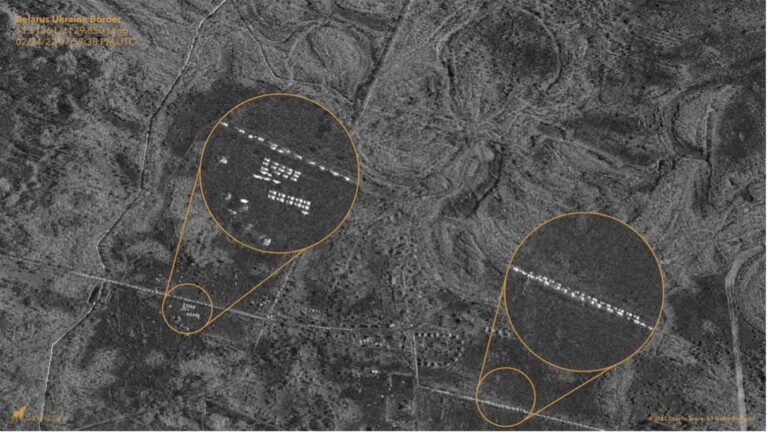
SAR imagery of Russian soldiers along Ukraine’s border played a role in generating worldwide support for Ukraine prior to the invasion. Commercial remote sensing companies like ICEYE, Capella Space and Maxar Technologies specialize in SAR technology and have provided invaluable data to both US and Ukrainian governments throughout the conflict. Ukraine’s military lacked systems that could track movement of Russian troops, particularly at night.
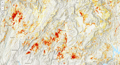
SAR data is being applied to predict disasters and protect the environment, too. In Arizona, GIS analysts are using SAR to track sinkholes that would worsen floods and put infrastructure such as highways and pipelines at risk. In Indonesia, researchers are using GIS analysis of SAR data to watch coastal ecosystems and decrease deforestation. In Iceland, teams project future glacier changes by looking at SAR-derived measurements of ice-surface velocity along with a numerical ice-flow model.
Across the planet, SAR sensors provide a look into the past and present. They are helping us see how Earth is evolving, how human behavior is influencing change, and what we can do to live in harmony with natural systems.
SAR proved its usefulness for military operations and now the de-classified technology is being commercialized. Companies want to make it more accessible, global, and reliable.
ICEYE, Capella Space, and Maxar Technologies are among the growing number of SAR providers. Their aid in the Russia-Ukraine War, and subsequent media attention, has helped increase demand, raise millions in funding, and land multiple government contracts.
Other sectors are taking notice of SAR, too, and software companies are adding functionality for processing and analyzing SAR data. Esri is one of them, providing AI and pretrained deep learning models for object detection and classification.
SAR sensors offer extraordinary terrestrial views, helping us see our world more clearly. The first earthquake hit Turkey and Syria in the middle of the night, knocking out power and intensifying darkness. But SAR satellites still detected—with precision—the impact. When Russia denied its plan to invade Ukraine, SAR imagery showed its troops amassing at the border, photos too dangerous to capture in person. SAR sensors used in the Titan submersible search quickly scanned the massive rescue area looking for objects at the surface of the ocean. Coming up empty, the team knew they had to look deeper.
The use cases for SAR technology are only beginning. The market is projected to grow 11.8 percent between 2023 and 2030, according to a recent report from Consegic Business Intelligence. Demand for SAR imagery is growing in agriculture, forestry, oil and gas, and environmental monitoring. Many experts believe it will play a role in our daily lives in the not-so-distant future. We may soon be wondering how we ever lived (or worked) without SAR.
Learn more about how imagery integrated with GIS drives insights, deep understanding, and decisive action.