December 13, 2017 |
December 14, 2017
Innovative shared ocean data, mapping and collaboration efforts are resulting in better decision-making for government, businesses and communities.
Around the world, communities are turning to the ocean for economic growth. A recent report by the World Bank describes how the oceans hold great potential for new and innovative activities with high economic value, however, the potential costs of marine ecosystem degradation from human uses are high. We need a new way to understand our oceans that incorporates environmental and social dimensions.
For the first time, the United Nations has formally adopted a Sustainable Development Goal that is ocean-specific:
“Conserve and sustainably use the oceans, seas and marine resources for sustainable development.”
This past June, I attended the event at UN Headquarters where 189 intergovernmental organizations gathered to confer about how to achieve this goal with over 1,400 commitments made. There was extensive consensus around the need for spatially explicit and publicly available information about coastal and ocean areas. Esri’s vision to create products that blend data and geography are one of the key tools helping us turn this consensus into reality.
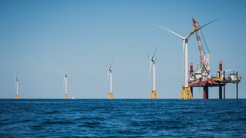
In the United States, we have collected information about our marine areas for decades, and in some cases centuries, but until the availability of geographic information system (GIS) technology, it was much more difficult to collect and display ocean use and model it on a spatial basis. We are now entering a time when mapping the ocean, making predictions, and visualizing information in real time is possible. As many communities, states and nations turn to the ocean to expand their blue economy, it couldn’t come at a better time.
With economies growing, the needs of industry expanding, and technologies advancing, competition for ocean space is increasing. Questions are being asked such as:

Publicly-available data allows us to create a shared vision for the sustainable use of ocean space.
In the past, much of the spatially-explicit data on ocean ecological resources and human uses was collected by numerous and disparate government agencies, academic institutions, private companies and conservation organizations. There was minimal sharing. In addition, state and federal management agencies were stovepiped in their approaches to permitting and planning.
Lack of agency coordination and data sharing frustrated both those seeking to develop new projects and those advocating for ocean conservation, and made it difficult for permitting agencies themselves to effectively balance the needs of all. Without a common vision for the use of ocean space, there were many inefficiencies and lost opportunities to proactively avoid conflict.
However, this has started to change. The Northeast, Mid-Atlantic, West Coast, Pacific Islands and Caribbean have established regional data portals with verified and publicly available data and maps. The data available includes information about fishing grounds for various sectors, areas of high primary productivity, whale migration routes, ship traffic and areas with high recreational boating activity. The data has been collected and contributed to by a wide range of sources including state and federal agencies, industry stakeholders, and representatives from tribal nations.
Where there are gaps in data, these unified portals have illuminated and allowed us to begin filling them. Esri’s internet-based mapping tools are essential components of each of the data portals, ensuring data layers can be appropriately visualized to drive decisions.
These data portals are the underpinning of ocean planning. Only by developing an understanding of where and how the ocean is being used and where the ecological resources are located, now and historically, can we create a plan that will guide the future.
The ocean planning process provides a venue for businesses, recreational users and conservation groups to come together with tribes, and state and federal agencies to proactively define a common vision for their shared ocean spaces, and lessen conflicts. In the United States, the Northeast and Mid-Atlantic have completed ocean plans and the Pacific Islands and West Coast are developing plans. Similar planning efforts have taken place around the world.
Publicly available data portals are already being used to support growth of a sustainable blue economy
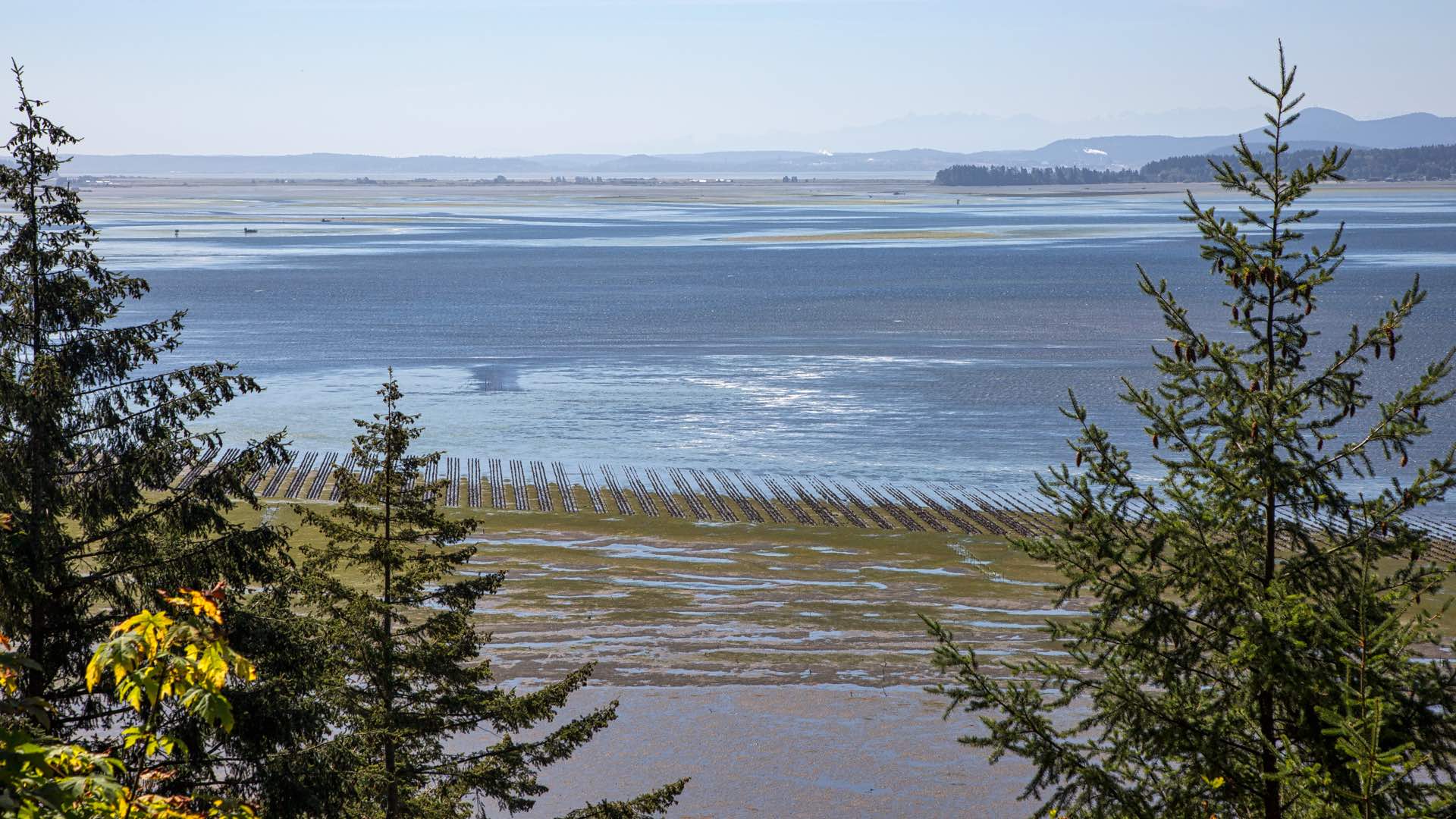
In the Northeast, easily accessible and comprehensive data allowed for the development of the first shellfish farm in Atlantic Ocean federal waters. The Northeastern Massachusetts Aquaculture Center (NEMAC) at Salem State University were able to use the Northeast Ocean Data Portal to define an area where the lines needed to grow blue mussels are unlikely to have negative effects on protected whale populations.
NEMAC also evaluated maps including fishing activity in the proposed area, vessel traffic, fishing closures and essential fish habitat to ensure conflicts were minimized. Now they have become an incubator site for those who are interested, including fishermen, to try offshore aquaculture, providing opportunities for new jobs and further growth of the industry. And this is just one example, there are many more.
Innovative approaches to growing the blue economy are being launched around the world by not-for-profits, ports, cities, states, regions and countries.
Around the country and the world, efforts are underway to jumpstart ocean-related sustainable economic development. Many of the economic opportunities that these innovation centers are working to advance rely on robust ocean data and planning. Some of these innovation centers include industries that are collecting this data using underwater robotics. Many of these initiatives include a physical place where some combination of businesses, scientists and educators come together to address ocean issues for example:
In other cases, innovation clusters are coordinating and convening virtually. For example:
The future is blue.
The emergence of ocean innovation centers and clusters is a clear indication of the worldwide interest in growing the blue economy. If we are to both support this growth and ensure that it’s sustainable, we must understand and map our coastal and ocean spaces.
GIS allows us to do this, advancing efforts to maintain ocean health and to accelerate sustainable blue growth around the world as envisioned by the new UN Sustainable Development Goal for the ocean. This is merely the beginning of the use of technology to help us make smart decisions about our oceans.
Learn how ocean scientists, resource managers, and conservationists use GIS to develop successful ocean policy and sustainable ocean practices. Learn how smart mapping makes mapping easier and more impactful.

December 13, 2017 |
September 26, 2017 |
September 21, 2017 |