
We can compare farm-to-farm, understand the techniques that lead to improvements, quantify that value, and push the best techniques to other farms.
Nyle Taylor
Taylor Shellfish Farms, the largest shellfish producer in the US, recently added a genetics program. Rising ocean acidity, and the need to improve the resilience of the clams and oysters it raises, helped drive this decision.
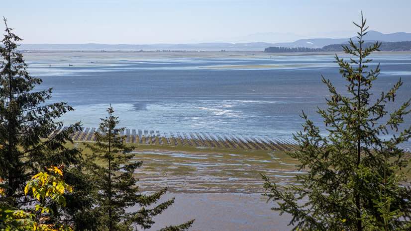
Starting in 2005, the company began to feel the impact of acidity on its 30 farms, which span 10,000 acres of tidelands in the Pacific Northwest. Hatcheries and wild oysters across the whole region saw a dramatic die-off estimated in the billions. By 2008, production at its hatcheries had dropped by 60 percent.
After years of uncertainty, oceanographers made the link to more corrosive acidic waters at higher levels in the water column. Acidification robs young oysters of the minerals they need to make their shells. Without abundant materials, the young oysters work too hard, exhausting themselves and making them prone to disease and die-off.
Hatcheries have invested in high-tech pH sensors to track and cut down on the acidity of the ocean water they pump into their operations. This added awareness helped them to quickly change practices, which led to an oyster rebound.
The ordeal sowed doubts about the long-term viability of the whole industry. Taylor Shellfish has heeded this warning, embracing technology to provide clarity on changing conditions and to add greater resiliency to their operations.
The company’s digital transformation is unfolding against a backdrop of growing demand and reduced output from wild fisheries. This puts aquaculture at the forefront of maintaining sustainable seafood production to feed a growing population.
We can compare farm-to-farm, understand the techniques that lead to improvements, quantify that value, and push the best techniques to other farms.
Tracing oysters
Taylor Shellfish Farms, a fifth-generation family-owned aquaculture operation based in Shelton, Washington, has steadily expanded the scale and scope of its operations over the years. It started with just one farm that sold the shellfish to a processor. With the next generation, it expanded into processing. More recently, it has added hatcheries and its own oyster bars to sell products direct to customers.
The journey of each shellfish starts in the hatcheries where Taylor Shellfish Farms breeds oysters, clams and geoduck; these “seeds” are then planted on its many tidal beaches; it stewards the shellfish until maturity; it then harvests and processes the shellfish; finally, it distributes the shellfish, bringing it to market and to the tables in its oyster bars.
Apps to keep track of each farm bed’s contents and maturity are central to the recently launched genetics program. Taylor aims to add traceability to this awareness, with the benefit of being able to correlate the farm practices present in each oyster’s upbringing. This knowledge will help Taylor with the nature or nurture questions that arise in genetic selection.
“We have shuckers that open hundreds of oysters every day in our oyster bars, and they can tell us which ones aren’t looking good,” said Nyle Taylor, Farm Project Coordinator, and fifth-generation family member.
This approach combines human sensors, who are experts in shellfish quality, with technology that aggregates information on what happened where. Geographic information systems (GIS) provides this backbone of capability, and handheld apps accessible anywhere are what farmers use to inform the system.
With knowledge of conditions and lineage, Taylor staff can pick the best offspring, looking for resilience to acidity, the greatest growth rates, appearance, and taste.
“We grow enough oysters that a 2 or 3 percent improvement in survival has real value,” Taylor said.
Sharing knowledge
This increased awareness starts in the hands of each farmer. The company provides apps that its farmers and fieldworkers use to track operations on all the farms, from planting the seed, moving the crops, and all maintenance that happens as harvest approaches. These apps communicate with a cloud-based GIS, which provides the ability to visualize and analyze the data to uncover operational inefficiencies.
“We can compare farm-to-farm, understand the techniques that lead to improvements, quantify that value, and push the best techniques to other farms,” Taylor said.
Apps also help keep track of inventories, budgets, and all of the various operational details. The company must comply with regulations at the local, state and federal levels that require a lot of permits, and most permits require a map.
For years, the company would submit hand-drawn maps for every permit, but this changed when it hired Erin Ewald to the position of Assistant Director of Regulatory and Environmental Compliance. Ewald had experience with GIS, and quickly put it to work for maintaining maps of farm beds. Her first step was to manage and update maps with GIS, and the second step was to make this data mobile.
“Now, we can compile information and push it to the right people,” Taylor said.
Easy-to-use apps are a critical component that make this transformation possible.
“These apps are so straightforward that our farmers see the benefit,” Taylor said. “They can use them while they do the work, saving them time, and they don’t have to come to the office to enter data when they’re all wet and muddy from the tide.”
Stewards of land and people
The company has adopted environmental processes to make sure farming practices work well with the natural environment in the Puget Sound, taking particular care not to harm the salmon and forage fish species around their farms.
The organization prides itself on its long history of environmentalism, achieving the only Aquaculture Stewardship Council certification in the United States that designates their shellfish are farmed responsibly.
Taylor’s leadership also thinks about its people and its land for the long term.
“Sustainability isn’t just about the environment for us,” Taylor said. “It’s also about operating responsibly with our employees and in our communities. Paying living wages and providing benefits are important to us, as is making sure our workplace is safe.”
Recently, one of their farm directors was in a serious car accident and suffered memory loss as a result of his injuries. But, mobile apps that capture farm details and processes have provided the farm manager with a backup, putting all the information about the farm in his hands, and providing assurances that he can pull up exact details when they’re needed.
“We’ve reached a size where having the information in everybody’s heads is not the best way of doing things,” said Taylor. “Our digital transformation has allowed us to bring each farmer’s knowledge into a shareable system that can be passed from generation to generation.”
Listen to the Esri & The Science of Where Podcast with Nyle Taylor to learn more about how location technology increases the quality of his company’s products.
GIS and Handheld Apps Power Taylor’s Digital Transformation
Taylor Shellfish Farms has expanded its use of GIS through many apps that farm managers and farm workers access on their mobile devices. It can now take real-time data on business, operations, and environment out to their 30 farms. The ability to view GIS data in the field helps the company understand the complexity of its operations.
The apps allow farm managers, with years of experience, to redline maps and share real-time changes in conditions or to record suggestions for where each farm could expand. The offline editing capability in Explorer for ArcGIS is crucial as many of the farms are in rural areas with spotty cell signal coverage. Explorer also provides a handy repository for data and attachments, such as for permits that can be shown to Fish and Wildlife inspectors when they come around.
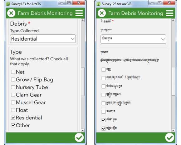
Taylor uses Survey123 for ArcGIS for field data collection, such as reports of shoreline debris or the presence of herring spawn, which it’s required to report to regulators. It has created multilingual surveys in English, Spanish and Khmer (the Cambodian language) to help make data collection a habit for diverse crews.
The company uses Collector for ArcGIS to update operational farm data about its farm beds. The data are used to better evaluate the status of various farms, freeing up information that was previously only in the minds of farmers.
Workforce for ArcGIS helps the collaboration with the local Squaxin Tribe in Oakland Bay, Washington, who have been harvesting shellfish there for centuries. A coordinated effort to improve the health of the watershed has been created by managing water quality sample assignments between their field workers and the tribe. Every rain with more than an inch of precipitation triggers sampling, and the company can select and assign sampling points—taking on the marine sampling and assigning freshwater sampling to their tribal colleagues.
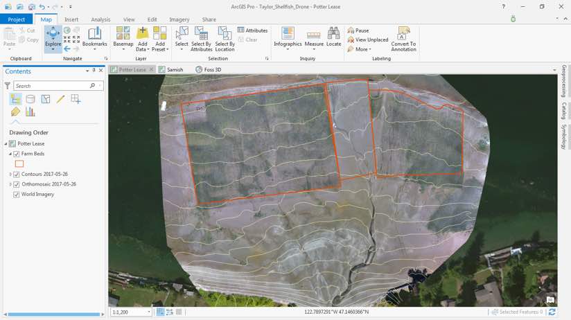
Drone2Map for ArcGIS has helped greatly improve the mapping of farm beds. Drones allow for the capture of beds at low tide with a clear understanding of elevation, which is a critical detail to locate the beds at optimum depth for farming each specific species. The company can better see beach drainage and layout the beds so the seed won’t get washed away.
Finally, 3D maps and story maps help share the “Tide to Table” story with customers, including virtual tours such as the video embedded below.