


June 24, 2025 |
Multiple Authors | Infrastructure
September 30, 2025
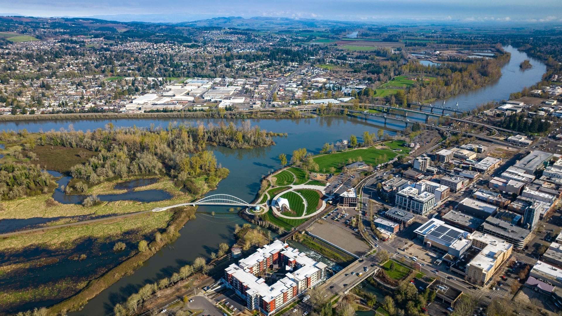
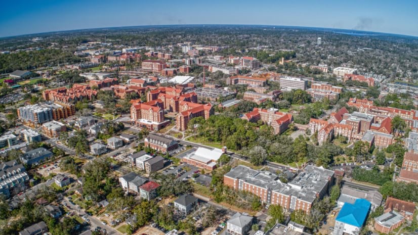
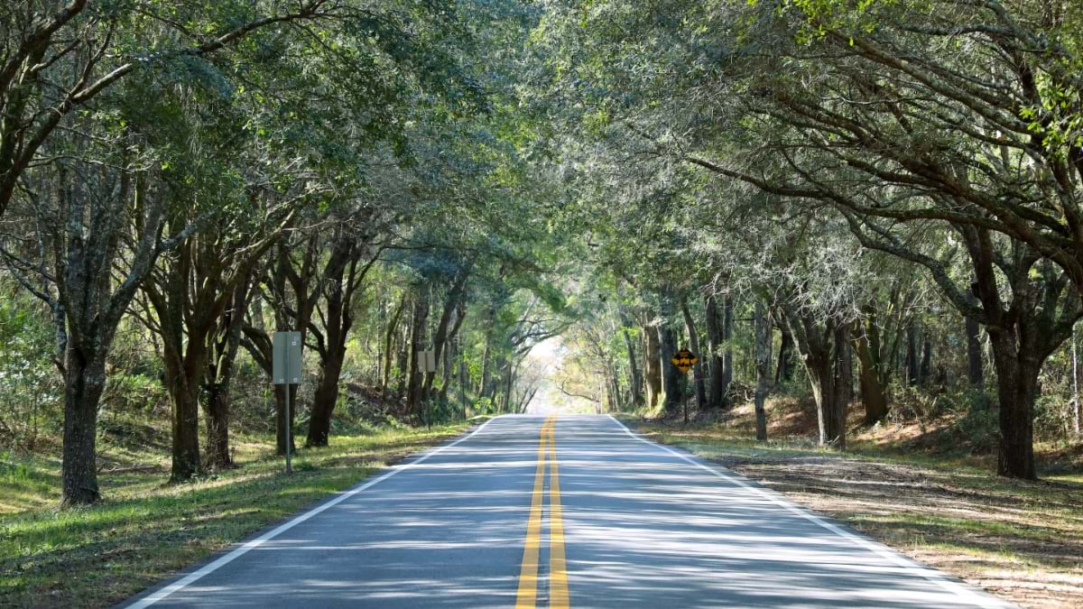
Tallahassee’s story begins with its trees. Shaded tunnels lined with moss-draped live oaks, sweet gums, and hickories trace centuries of history from pre-Columbian trails to Spanish missions and antebellum plantations.
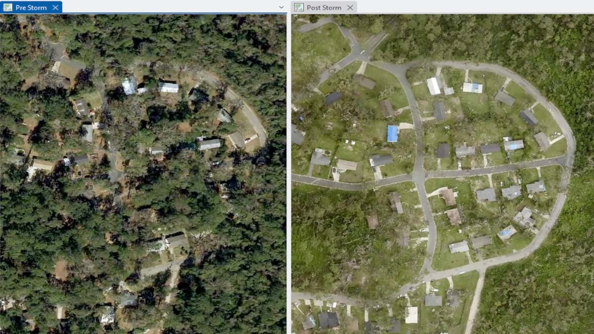
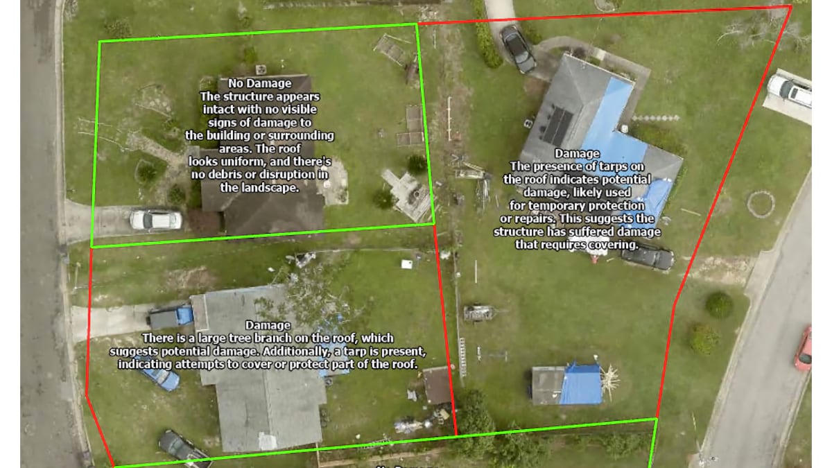
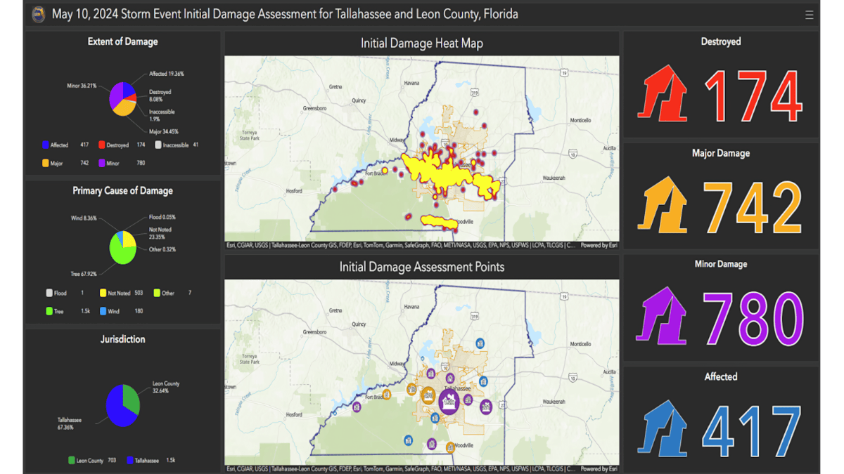
Storms—hurricanes and tornadoes—take their toll on this green crown. When severe weather hits, public works crews with the city and county follow close behind to start repairs. But manual inspections can take weeks, even months, to assess the damage. Conventional aerial image analysis and digitization of old printed photos is not much faster.
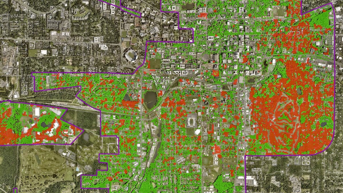
Recently, Jason Cox, a systems analyst with Tallahassee – Leon County Geographic Information System (GIS) Department (TLCGIS), developed a new technique to expedite tree restoration. He uses AI models in GIS software to detect changes in tree density after storms. The model flags damage patterns found in before-and-after aerial images. The data and analysis feeds into GIS maps decision-makers can use to calculate repair costs and pinpoint resource allocation.
First responders are also using this powerful combination of GIS and AI, known as geospatial AI, to get in a better position during emergencies. Cox supplies rescue crews with smart maps that utilize geospatial AI datasets. These can recognize lanes in parking lots, alleyways, and commercial spaces to bring first responders closer to people in need.
“It was something that we were able to generate en masse,” Cox explained about the map improvements. “It took a couple of weeks of cleaning up the geometry and adding attribute information, and then we serve it to the public and to emergency response partners. It represents a big advancement—providing that extra context that we didn’t have before.”
Just a few years ago, integrating those pathways into first responders’ navigation systems seemed like a far-off possibility. “We couldn’t afford to do it,” said Scott Weisman, head of TLCGIS and a 31-year veteran of the program. “We would have to hire people to do that manually, and we never had the resources to do it—until now.”
Cox’s path to geospatial innovation started 14 years ago when he was a fresh-faced temp with a new degree from the University of South Florida. Weisman brought Cox onto the team to help Leon County develop a faster, more accurate way to bill for solid waste and stormwater services. The work involved maintaining a large dataset—all the residential buildings in the county and relevant classifications for service rates. The data needed regular updates, edits, and audits.
A knack for geoprocessing earned Cox a full-time position. He expanded his scope to other large datasets that needed frequent checks and updates. For a time, he managed the record of all the addresses in the county.
Esri’s ModelBuilder and Python programming whetted his appetite for automation. He devoured all the training and information he could find, eventually arriving at a blog post about the Building Footprint Extraction–USA model. This early geospatial AI model could automate a key workflow—checking field images against recorded values in the dataset.
Cox wanted to experiment, but at the time, TLCGIS computers didn’t have the discrete graphics cards needed for early AI work. Using a gaming computer, Cox ran the model on an image of the entire 7,000-plus square miles of Leon County. It took four days to process but he found the feature output to be incredibly accurate.
The promise of AI-powered digital tools—to do more with less—is a familiar refrain heard by local government administrators. Often challenged to deliver services with reduced or stagnant budgets, officials look for ways to optimize. Over the years, TLCGIS has laid the track for dozens of departments to innovate with location intelligence. With geospatial AI, Weisman and Cox have a work multiplier—an innovation high speed rail of their own.
Tallahassee’s recent AI-powered innovations join an already prodigious portfolio of projects:
Few local GIS offices can boast such a well-executed set of public sector GIS apps and tools.
Even fewer take on the responsibility of creating content for their city’s bicentennial celebrations.
Weisman explained, only half in jest, that TLCGIS staffs a resident historian. Marcus Curtis is an expert GIS analyst and insatiable history buff. He built the History in Your Hands program for the 200th anniversary of the founding of the historic city in 2024. The map-guided exploration of Tallahassee neighborhoods garnered national media coverage and awards from historical societies. It brought about new and transformative connections.
“Marcus has reestablished plantation boundaries from old census maps and deeds,” Weisman said. “He’s catching the eye of real historians.”
Other staffers pair GIS and website development, or GIS with Adobe Creative Cloud for print production.
Passion projects are part of an approach designed to raise the profile of TLCGIS across departments in Leon County. This visibility is crucial, given how the Tallahassee – Leon County government is structured.
TLCGIS serves the City of Tallahassee, Leon County Government, and the county property appraiser. They also collaborate with state agencies and provide mutual aid to other counties when called upon. Program costs are shared between partners. The more the offices collaborate and drive value outside the program, the more its recognition grows and expands into new projects.
“One of the advantages of the structure we have in place—it includes an executive level, a steering committee, and a user group level,” Weisman explained. “Data sharing is streamlined because no memorandums of understanding are required. The trust within the program facilitates this process.”
The city employs other GIS professionals outside of TLCGIS. Weisman—and his dedicated team of 13 full-time employees and two interns—evangelize about the technology and push the envelope of what GIS can do.
Weisman takes great care in curating the TLCGIS team, handpicking individuals who have demonstrated a deep passion and creativity in their work.
The formula keeps morale high and turnover low. “Everyone has what I call a superpower, a special skill—they are a subject matter expert,” Weisman said. “People who can dig into a particular topic and become experts in it.”
Superpowers may take a few years to develop, but the signs are always there. Jason Cox, who designed the geospatial AI tree restoration assessment tool and first responder basemaps, demonstrates this evolution.
Eventually, Weisman equipped Cox with workstation PCs from Lambda Labs designed for AI and machine learning workloads. Other office computers were upgraded with video cards and CPUs suited to geospatial AI workloads. Using pretrained geospatial AI models from ArcGIS Living Atlas of the World, Cox developed applications for partner agencies: coloring historic aerial images, calculating service fees, and visualizing tree densities with geospatial AI.
“The biggest benefit to us at TLCGIS is that geospatial AI significantly lowers the barrier to entry for updating our datasets,” Cox said. “It saves me about three weeks of manual review every year just with building footprint extraction models alone.”
The time saved is reinvested into the superpower. “There may be lots of organizations that are dipping their toe into AI and are doing some similar things,” Weisman said. “Most people are treading water to keep up with the requests they have come in, but we are fortunate to manage workloads and innovate at the same time.”
The next frontier? Generative AI. Already, Cox has begun experimenting with large language models in ArcGIS Pro. Specifically, the Vision Language Context-Based Classification models, using GPT-4 to query imagery to build out classifications and features. Cox adds, “The ability to kind of describe ground conditions—not just extract features, identify features, but actually describe the condition of features and imagery—I believe is nothing short of amazing.”
While terms like “superhuman” describe how geospatial AI works, it’s important to remember that silicon and algorithms alone don’t solve problems.
TLCGIS reminds us that humans drive innovation. Humans with GIS superpowers who put geospatial AI to work to accomplish more.
Learn more about how artificial intelligence in GIS helps user analyze complex challenges with vast datasets to enhance operations.