
June 6, 2023 |
Carrie Speranza | Public Safety
By early October 2025, Western Alaska’s communities were deep into winter prep. Stocking chest freezers with moose, caribou, salmon, and berries. Winterizing equipment. Battening down for months of being cut off from the rest of the state. Barge operators had already pulled their boats from the water. This is the seasonal rhythm of a place people have called home for thousands of years.
Then the storms came. The first hit October 8, bringing flooding and erosion serious enough to trigger disaster declarations. Three days later, the remnants of Typhoon Halong arrived.
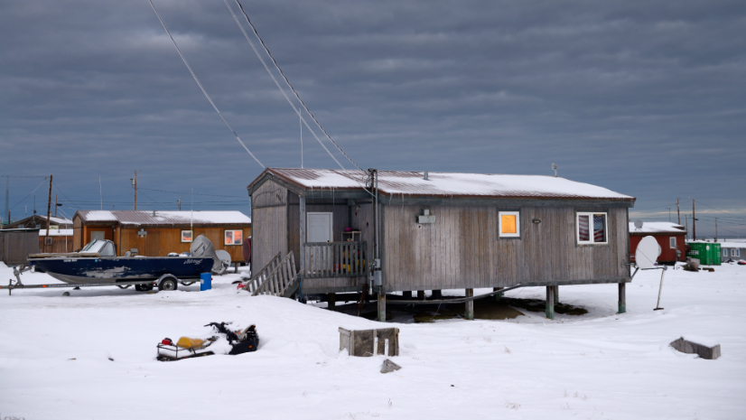
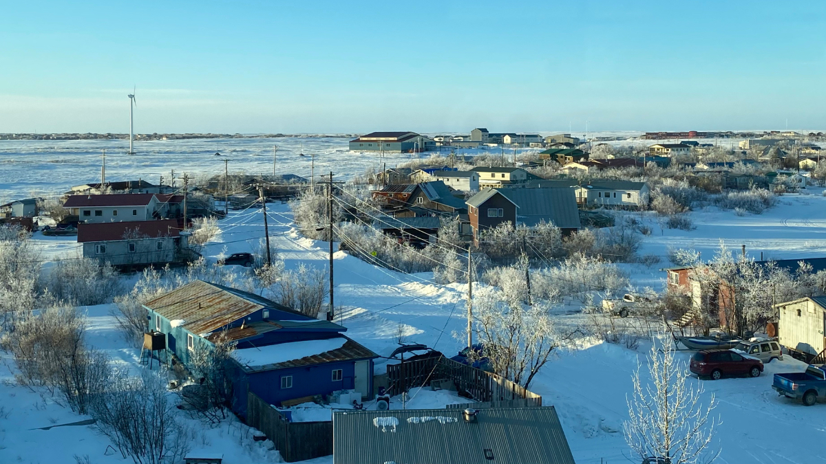
Western Alaska is flat. Villages are set on marshy river deltas, with homes up on stilts, barely above sea level. No hill to retreat to, no high ground to rebuild on. Halong’s storm surge traveled 60 miles upriver, reaching communities nowhere near the coast. Kipnuk, the hardest-hit village, sits four miles from the Bering Sea. The state estimates 90 percent of its structures were severely damaged or destroyed.
Houses floated off with families inside. The boards that serve as roads were washed away. Freezers full of winter food were lost to the floodwater, leaving families without supplies to last through the spring thaw.
The storm triggered Alaska’s largest mass evacuation. Military aircraft carried hundreds of residents to Anchorage, Bethel, Fairbanks, and Juneau, each person allowed one backpack and the clothes on their back. Nearly four months later, hundreds were still in Anchorage hotels. State officials had told lawmakers many should not expect to return by summer. Some had decided not to go back. For families from villages where everyone knows their neighbors and food comes from the land, hotel life in a city is its own kind of loss.
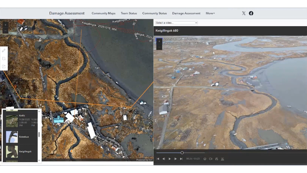
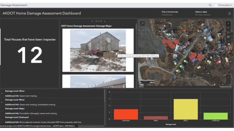
The Alaska Department of Transportation and Public Facilities (Alaska DOT&PF) had seen the storm coming and moved early. The department pre-positioned a few two-person drone teams closer to the expected impact zone and had 12 teams in the field within 24 hours. The teams were equipped with tools and food so they wouldn’t be a burden on villagers. Their job: capture the damage and relay needs back to incident command. The imagery would feed into geographic information system (GIS) technology to map the destruction and coordinate the response.
As the storm approached, staff were asked if they wanted to help. Many jumped at the chance even though they were headed into many unknowns. They had to pack for a week and leave the same day.
Getting people into the field was a different calculus. Send a large crew into a village of 300 with no grocery store and no spare beds, and the responders eat the food and fill the beds—trading one crisis for another. So, Christine Langley, director of the Division of Data Modernization and Innovation at Alaska DOT&PF, and the Incident Command Team, kept field teams small by design: two people, carrying their own food and gear in totes sized for the small planes that could land on village runways. Twelve teams deployed across more than 40 communities.
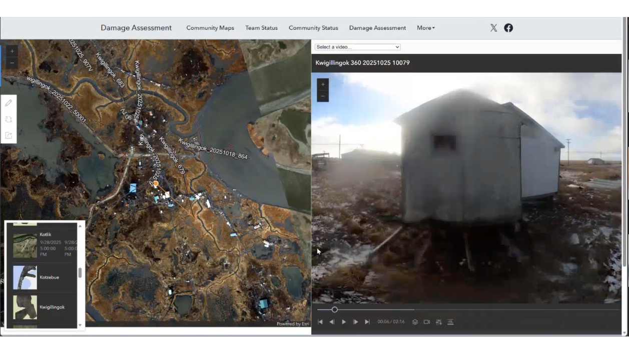
Daylight dictated everything. Teams sometimes had three hours on the ground before the helicopter had to turn back as the shortest days approached. They flew over every village to collect aerial imagery, strapped on GoPro 360 cameras, and rode four-wheelers up and down boardwalks with community members driving. Along the way they gathered ground-level intelligence: power status, water plant condition, whether the bridge to the airport was still standing.
Data flooded into incident command in Anchorage and Bethel. Alaska DOT&PF had never operated at this scale. They were ingesting feeds from dozens of communities every evening and assembling GIS maps by morning before the next day’s shrinking window of light. Satellite coverage thins heading north, so the team was almost always 24 hours behind. Hard drives arrived via GoldStreak, Alaska Airlines’ service for shipping packages on passenger flights, or on charter planes.
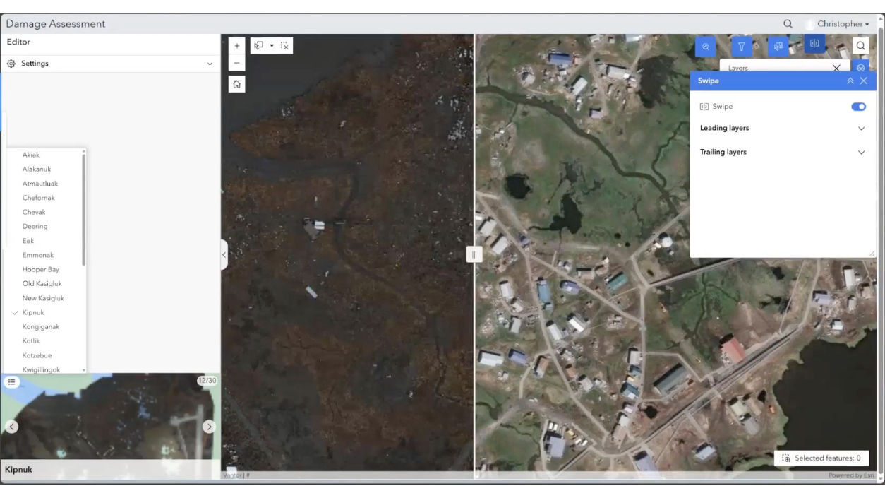
The team built a GIS comparison tool anyone could use: a slider between pre-storm and post-storm imagery. In Kipnuk, buildings disappeared from one side to the other. Houses that looked fine from above were piled against each other. Others had rotated or vanished from between neighbors. “When water has come in and erased everything, it gets harder to notice what isn’t there,” Langley said.
Rural Western Alaska has no roads. Residents get around on board roads: elevated wooden walkways wide enough for two four-wheelers to pass. There are no street addresses. The mail doesn’t come to your door. In communities of 200 to 300 people, everyone knows whose house is whose.
“If the airport is damaged in a storm, there’s no route into that community,” Langley said.
Alaska DOT&PF operates hundreds of remote airstrips. But by mid-October, the supply chains that serve Western Alaska had shut down for winter. Construction materials were scarce. Crews scattered. When the storm hit, there was no ready way to move goods, materials, or people, and the freeze-up was coming fast.
Multiple generations share a single home. Materials are so expensive that each house costs $750,000 to build, and there are never enough. When an emergency hits, there are few other places to go. The community maxes out who can sleep on whose couch, and after that, the options run out.
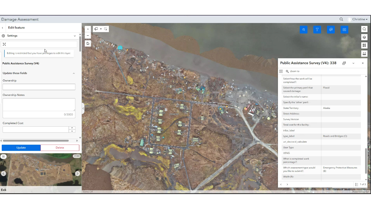
Every damaged structure needs an assessment and a damage rating before federal funds flow. Standard process requires a homeowner on site, which was impossible for hundreds of evacuees scattered across the state. Alaska DOT&PF worked with FEMA to establish a new approach: digital assessments without homeowners present, analyzed with the help of a large language model (LLM). It was the first time an LLM had been used for damage assessment at this scale.
Damage assessment apps were created and shared via QR codes on printed cards. Take a photo, speak your notes, move on. Gloves and frozen fingers made touchscreens nearly useless.
The LLM, trained on federal damage criteria, analyzed every photograph and field note, assigning damage ratings and response categories. Staff in the field had written things like “house floated away inaccessible.” The model parsed what was visible in the image and matched it against the assessment scale. With calibration, it processed hundreds of structures with consistent details.
It also had to learn what wasn’t damage. Outside assessors from the Lower 48 flagged peeling paint and worn siding. In rural Alaska, that’s normal. “Paint is $70 a gallon at a minimum,” Langley said. “You don’t paint a lot when it costs that much.” The same gap applied to construction. Houses out here sit on stilts with insulation underneath. In a flood, that insulation becomes a waterlogged block of ice that will not drain or dry in below-freezing temperatures. What you’d fix with a tarp in Georgia is lasting damage in Alaska. The model had to be tuned to these realities, and so did the people.
The GIS team created polygons around each structure and assigned identifiers. For instance, the structure Kipnuk 008 was used for one house and it linked to the other names the community used, such as its nickname and the family name of people who lived there.
The imagery and assessments accelerated the disaster declaration. Instead of written estimates, Alaska DOT&PF showed decision-makers the before and after at scale. “There is no way you could write a description of what you can see there,” Langley said. FEMA accepted the AI-assisted approach as a valid method for reimbursement, a first.
Alaskans look out for each other. “I might help someone because their car broke down,” Langley said. “Tomorrow it could be me. That’s an Alaskan concept we live every day.” Staff worked for weeks straight. Community members drove strangers on four-wheelers to survey damage. People across the state donated supplies. Nobody asked whether it was in the budget or on the clock.
Out in the villages, workers are drilling through snow and ice to set posts for new board roads. They are how neighbors reach neighbors, how someone checks on an elder, how a community functions when the responders are gone. Rebuilding them helps knit the community together.
The rapid shift from drones to GIS maps to apps built for specific needs is now the model going forward. Langley, who describes her GIS skills as “right about zero,” built the comparison tool herself by modifying off-the-shelf software to fit what the response needed. That flexibility, people in the field shaping tools to the problem in front of them, is now business as usual.
The high-resolution drone imagery collected during the response will become a statewide GIS resource. Three hundred users were added to the platform during the crisis. What started as an emergency is now geospatial infrastructure.
The infrastructure behind it is improving too. Armada, an edge computing company, has placed a ruggedized data center in Fairbanks and manages satellite connectivity across remote field sites. That means drone imagery can upload directly from a village instead of traveling out on a hard drive, and it gets processed into terrain models and damage assessments in-state rather than being sent to cloud servers thousands of miles away. During Halong, that round trip kept responders waiting. Going forward, the gap between capturing imagery and acting on it shrinks to near real time.
In Anchorage, hundreds of families from the delta remain in hotels. Some will return. Some won’t. They are among a growing number of Alaskans displaced by extreme weather, climate refugees in their own state. But self-reliance is built into this place. Western Alaska is not the only coastal region facing stronger storms, rising seas, and thawing ground. The tools built here, the drone workflows, the AI-assisted assessments, the GIS platforms that turned chaos into usable data, will travel. The next community facing the next storm will not have to start from scratch.
Explore how GIS supports emergency operations before, during, and after a storm.