January 27, 2026 |
Sunny Fleming | Conservation
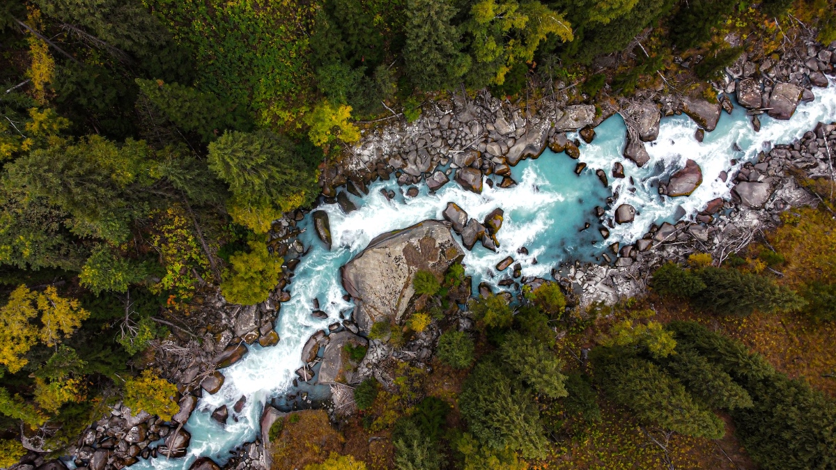
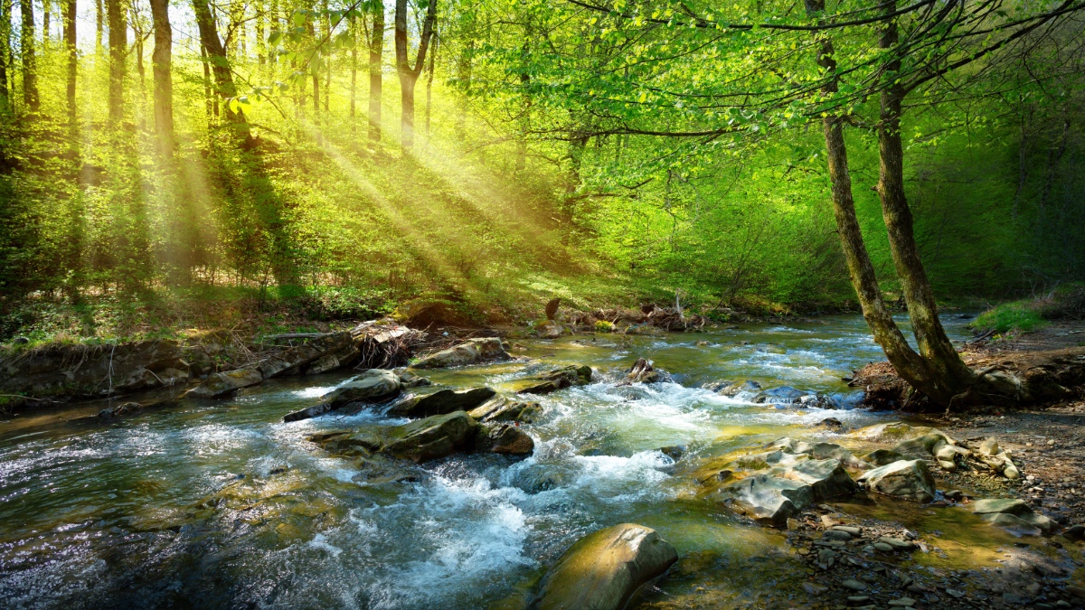
Seventy-five percent of the world’s accessible freshwater originates in forested watersheds. Half of all Americans drink water filtered through forests. There is a powerful connection between trees and water. But until December 2025, no one had built a tool that could show—at global scale, down to a 30-meter pixel—exactly where planting trees would deliver meaningful water benefit.
The Arbor Day Foundation changed that with the Forest-Water Impact Map. Built in partnership with 52impact, a Netherlands-based sustainability consultancy, the map lets corporations, conservation organizations, and reforestation partners calculate the water co-benefits of any planting site anywhere in the world. It’s the first tool to apply a globally accepted water-benefit accounting standard at this scale.
To build the Forest-Water Impact Map, the Arbor Day Foundation started with an act of radical imagination. “Some partners speak in trees planted, others in gallons of water or acres restored. This map gives everyone a shared language and lets us connect the conversations about forests and water in a way that guides action,” said Ben Wilinsky, Arbor Day Foundation director of Partnerships and Innovation.
To understand why this map matters, it helps to have a deeper understanding of tree planting and its roots.
Arbor Day, the tree planting holiday, was first celebrated in Nebraska in 1872. Early settlers hoped trees could help ease the burdens of life on the Great Plains. A century later, the need for trees was gaining widespread recognition. In 1972, Arbor Day became a national holiday in the United States, and the Arbor Day Foundation was formed. The Foundation was created with a mission to inspire people to plant, nurture, and celebrate trees.
Today, the Foundation and other tree champions across the world are applying data and technology to tree planting to make trees measurable instruments of improvement. Corporations now track the water, biodiversity, and carbon implications of reforestation projects, similar to how they track operating costs. Nature-based solutions have moved from the margins of sustainability strategy to their center. The question is no longer whether forests matter to water, but precisely where they matter, and by exactly how much.
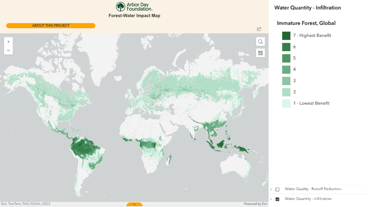
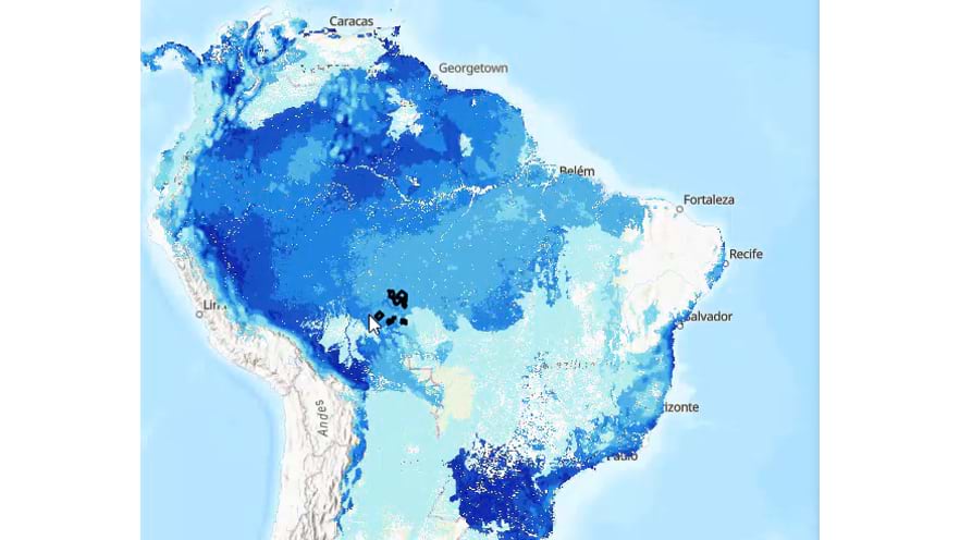
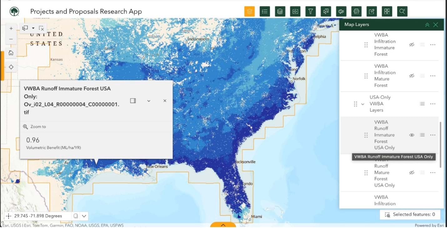
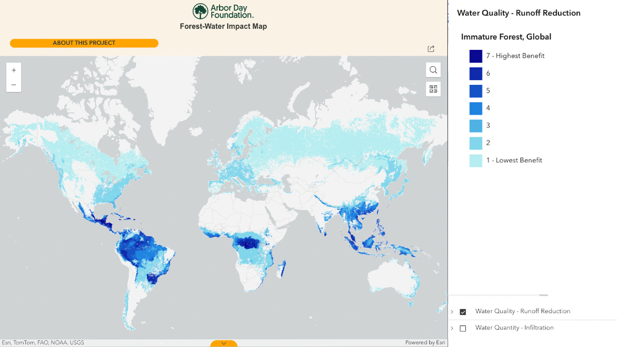
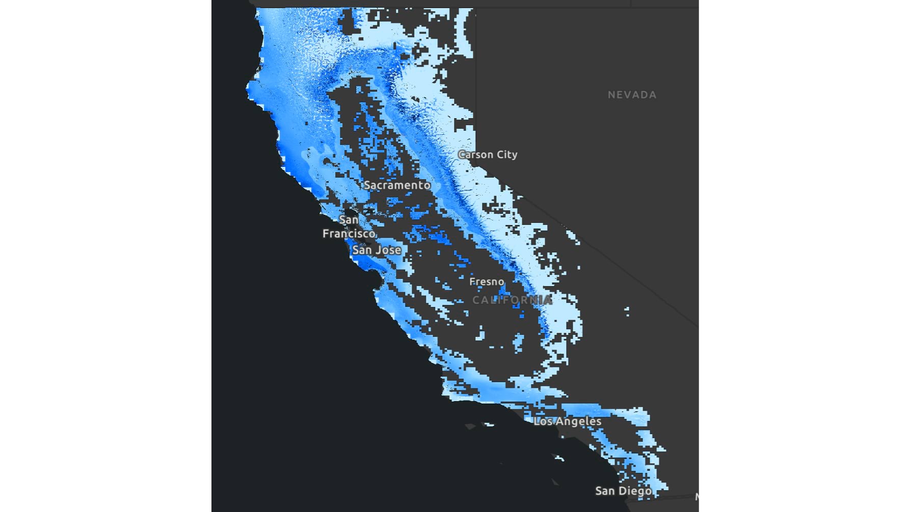
The Arbor Day Foundation’s Forest-Water Impact Map (FWIM) is a global dataset at 30-meter-per-pixel resolution covering every part of Earth where reforestation makes ecological sense. It answers the question, if trees were planted here, what volumetric water benefit would result?
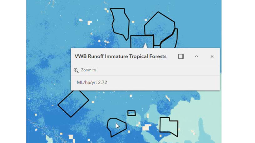
The result draws on the World Resources Institute’s Volumetric Water Benefit Accounting framework, a methodology that defines more than 1,100 nature-based interventions for improving water health, from wetland restoration to leak detection. For the FWIM, the Arbor Day Foundation focused solely on reforestation.
The inputs span high-resolution climate data, digital elevation models, soil hydrology classifications, and biome datasets across fourteen terrestrial ecosystem types. The map is separately rendered for tropical, temperate, boreal, and Mediterranean forest ecoregions—a design choice that preserves the nuance a single global view would flatten. At global scale, the water gains in tropical forests are so large they would obscure meaningful variation everywhere else.
Snow accumulation and melt are factored in, ensuring that high-elevation and seasonal landscapes are calculated as accurately as tropical ones. The outputs track two indicators. Avoided runoff measures rainfall that trees stabilize in soil rather than letting it rush downhill, carrying sediment and pollutants toward waterways. Increased infiltration measures water that percolates through root systems to replenish groundwater.
Developing the FWIM required a uniform pre-project baseline. Rather than map constantly shifting land conditions, the team modeled the entire world as sparse shrubland—a deforested Earth, then calculated what a young forest, roughly ten years old, returns to the water cycle. Processing that calculation across every qualifying pixel took weeks. “For every 30-by-30-meter pixel in the entire world, we can now quantify in megaliters per hectare per year what that volumetric water benefit is,” said Derrick Frese, Arbor Day Foundation director of GIS.
The publicly available version of FWIM expresses results as a gradient from highest to lowest potential. Precise figures require local validation before anyone stakes a commitment on them, so the tool withholds raw numbers by design, giving partners direction without inviting misuse. The Arbor Day Foundation’s internal version of the model goes further, delivering the actual megaliter-per-hectare figures that power the Foundation’s own project evaluation and corporate proposals. “We give corporations a scale, which is directional enough that they can make sense of the results,” Wilinsky said.
Before the FWIM, evaluating the volumetric potential of 30 priority locations required hours of manual data input and running calculations site by site. Now the same work takes minutes. The equation that was once solved project by project has been scaled across the entire world, making it faster for companies to identify where forest investment will deliver the most meaningful return on their water stewardship commitments. “You can’t talk about trees without talking about water. This helps us do that in a way that’s clear and understandable,” Wilinsky said.
Salesforce put the tool’s reach on display. In a public request for proposal focused on water stewardship, the company directed prospective restoration partners to the FWIM to quantify water benefits. Now, that model now being followed by corporations that rely on water for everything from food and beverage production to data center operations. The FWIM gives them all a common language connecting forest restoration to business risk, sustainability reporting, and long-term investment.
The map also corrects a costly assumption. The benefits of trees are directly tied to where they’re planted. For example, in some degraded aquifer systems, trees draw down water tables rather than replenish them. A global picture of both positive and negative potential guides partners toward projects where the work is warranted, and away from projects where it isn’t.
The Arbor Day Foundation’s FWIM was built on five years of historical climate data, which means its assumptions reflect the weather patterns of a recent but already-receding past. The team acknowledges that it will need updating. It provides a baseline, a scientifically grounded starting point the field had entirely lacked before December 2025.
That baseline gives corporations, NGOs, local implementers, and foundations a shared reference frame for decisions that play out over decades. The Arbor Day Foundation operates across more than 60 countries and 100 basins worldwide—and every one of those projects benefits from a shared map that shows where forest restoration and water health intersect. Trees planted today in high-impact watersheds will be doing water work 40 to 100 years from now. The FWIM makes it possible to know, before the first seedling goes in, where trees might be most meaningful.
What comes after is already taking shape. Sensor networks are generating denser ground-truth data. Satellite imagery is sharper and more frequent. AI is aggregating disparate environmental datasets and cutting the manual effort that made a project like this so expensive. Data scientists are developing better methods to validate and recalibrate models against observed outcomes. The FWIM is a landmark—and a floor. The next generation of tools will build from it, and the picture of where forests sustain our water will only get clearer.
Since that first Arbor Day in 1872, greater science has given greater insight into how trees can strengthen our world’s ecosystems and shape a better future for people and the planet.
Learn how GIS is powering conservation work around the world.