For multinational companies, dealing with political and economic uncertainty is an everyday reality. Executives must regularly adjust plans to contend with global and regional events that affect customer behavior, the stability of markets, the safety of employees, and the productivity of operations.
A recent Harvard Business Review (HBR) article details several strategies companies have deployed to deal with uncertainty, including social unrest in Venezuela, Yellow Vest protests in France, Brexit, and US-China tariffs.
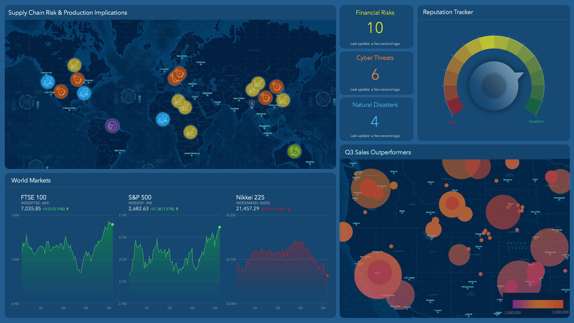
As those and other events roil local and global markets and threaten business resilience, innovative companies are turning to the geospatial cloud for a common view of operations—in essence, a digital map of their global business risk.
Avoiding Short-Term Risk
Large multinational companies have long maintained teams to manage currency risks and regulatory compliance. Many also monitor weather hazards and other factors as they seek to reduce risk, ensure smooth operations, and reduce costs.
Increasingly, these organizations also track a broad range of current events and conduct scenario planning to weigh the implications of social and political shifts. The geospatial cloud is a central source of information for them, providing risk-related data about locations around the world. Viewed through a geographic information system (GIS), that data can create a common operating picture that guides executives to smarter short- and long-term business decisions.
In one example of short-term planning, the risk management team at a Fortune 50 financial institution tracks its executives on a GIS-powered map—all by way of their IoT-powered smart devices. If analysts see disruptive events—demonstrations, active shooters—near a planned venue, they can adjust the executive’s schedule accordingly.
[To read more about enhancing corporate security and resilience, visit this e-book.]
Planning for the Long Term
Data from the geospatial cloud also helps companies track longer-horizon events. Executives can evaluate the implications of upcoming policy changes or world events, and see the effects that demographic shifts could have on supply chains and patterns of customer demand.
The HBR article outlines the hedging strategy that Jaguar-Land Rover is using to deal with Brexit risk—shutting down four UK plants in April to cope with anticipated disruptions to its value chain. The automaker has chosen to act decisively in the location where it anticipates the greatest disruption, while maintaining business as usual at plants in Brazil, China, and India.
That example echoes the scenario planning that takes place at General Motors. The automaker’s strategic risk management team uses GIS to create a common operating picture of the global supply chain, including the web of relationships that connects thousands of GM suppliers.
The company uses GIS to respond quickly to disruptions in its supply chain. If a worker strike shuts down a plant or a typhoon disrupts supplier production, analysts use map-based analytics to see which vehicle parts are affected, then activate contingency plans to mitigate any slowdowns. With that common operating picture, GM can respond to disruptions in hours or days instead of weeks. That minimizes risk for a company that produces 10 million vehicles per year in more than 100 countries.
[For a short video on how GM manages this global risk, click here.]
The Decision to Shift, and the Location Intelligence to Do It Well
In the case of Brexit, the HBR article also notes that banks have shifted a significant share of activities away from London to locations in Paris and Frankfurt. Meanwhile, Dyson recently decided to move its UK headquarters to Singapore, where it sees the greatest opportunity for growth. (Dyson maintains that the move was not related to Brexit.)
Much of the data needed to see and anticipate global conditions is available in the geospatial cloud. And when geopolitical or economic conditions prompt changes in a company’s operations, that cloud-based data can be plotted on GIS smart maps to help executives examine what-if scenarios.
Whether a business risk stems from geopolitical disruption, weather events, or demographic changes, companies with a reliable map of global operations are acting quickly and decisively to mitigate the adverse impacts.
The Esri Brief
Trending insights from WhereNext and other leading publicationsTrending articles

December 5, 2024 |

March 3, 2026 |

June 23, 2026 |

March 17, 2026 |

April 7, 2026 |

June 9, 2026 |