As 2020 continues full steam ahead, we are here to introduce a new release of ArcGIS Enterprise!
10.8 is now available with updates and enhancements throughout the product, from administration to data, maps, and apps.
This blog will cover the highlights. Keep an eye out on the blog site for deeper dives into topics like ArcGIS Enterprise sites, read only mode, updates to documentation, and much more.
Support note: ArcGIS Enterprise 10.8 is a short term support release. For more information on support lifecycles for ArcGIS Enterprise, visit the blog Update to ArcGIS Enterprise Product Lifecycle.
Let’s look at what’s new!
Administrative
Read only mode
Read only mode “freezes” your ArcGIS Enterprise environment so that administrators can perform system maintenance, install patches, and upgrade without experiencing downtime or data loss. Read only mode has previously existed for individual components in ArcGIS Enterprise like ArcGIS Server and ArcGIS Data Store (and continues to). However, putting these components into read only mode did not prevent some operations like editing data in the Enterprise portal and didn’t apply to specific servers like your hosting server.
With 10.8, you can put all of ArcGIS Enterprise into read only mode. In read only, users will be able to log into and view content in ArcGIS Enterprise, but they will not be able to make changes to data, create or save items like web maps, or update administrative settings. For a full list of operations allowed and blocked see the help topic Read-only mode in ArcGIS Enterprise.
As an administrator, you can set ArcGIS Enterprise as read only within the Portal Administrator Directory (shown below). There, you can customize the message displayed to users after an action is prevented because of read only mode.
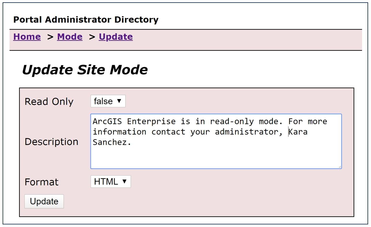
Note that since read only is new as of 10.8, you’ll be able to reap the upgrading benefits when upgrading from 10.8+ to higher versions.
Information banner
Many administrators have asked for a custom banner within ArcGIS Enterprise and ArcGIS Online that displays information like the status of the environment, important notices, and even classification levels.
With the new information banner, you can customize a static message that appears for every user at the top and bottom of each page in the Enterprise portal. Your banner can notify users of upcoming system maintenance, direct users to new resources or information, or even be used to distinguish your ArcGIS Enterprise environment from your ArcGIS Online organization.
You can see the information banner in action here in blue:
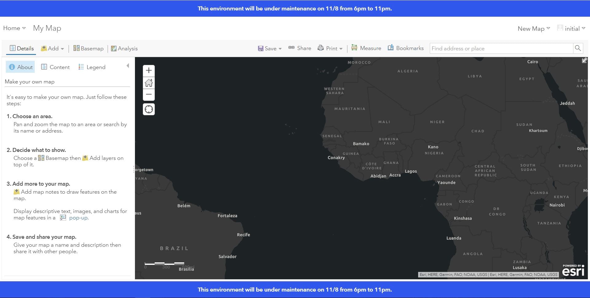
For more information, see the Configure security settings > information banner help topic.
Access notice
It has also been a common request to provide a pop-up notice that must be accepted before accessing ArcGIS Enterprise and ArcGIS Online.
The new access notice appears as a dialog whenever someone visits ArcGIS Enterprise and/or any URL leading to it. Before granting further access, the user must accept the notice. If the notice is declined, the user is denied from accessing the environment.
Here is an example where I am visiting an ArcGIS Enterprise environment with an access notice (note you can fully customize the text here):
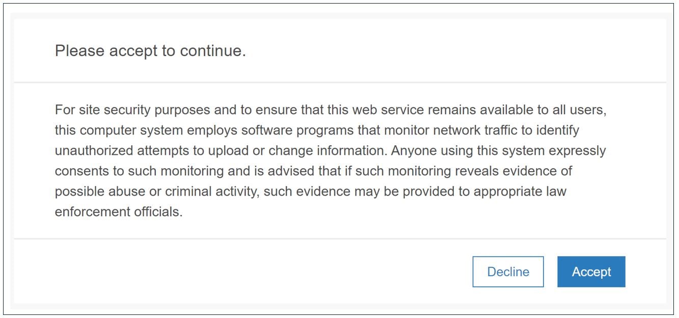
You can use the access notice in any way that suits your organization. A common use case is to require acceptance of terms and conditions before granting access to the environment.
We’d love your feedback on how you are using or planning to use the information banner and access notice.
For more information, see the Configure security settings > access notice topic.
New webhook events
Webhooks watch for certain events in the ArcGIS Enterprise portal and send emails, SMS messages, and other notifications to users and apps when they happen. An example would be when a new item is added to a group, notifying group managers via email so they are aware of the update.
At 10.8, new webhooks triggers are available for creating, updating, or deleting user roles. This is helpful when you have multiple administrators creating new custom roles for users who need different privileges in ArcGIS Enterprise and want to be sure all administrators know of these new roles.
Another webhooks enhancement at 10.8 is the ability to subscribe to specific events across all items, groups, or users.
Say I want to know whenever any group is deleted. Before 10.8, I could create a webhook that would send an alert whenever a specific group was deleted or whenever any update was made to any group, which can be noisy. 10.8 is the perfect middle ground; you can create a webhook that sends an alert whenever any group is deleted:
/groups/delete
For more information, see the what’s new topic under Organization administration > new webhook trigger events.
Server Manager updates
Some small but mighty updates in Server Manager make it easier to search and find services. Updates include the ability to search your services by instance type – shared or dedicated – and by authoring client.
This makes it easy to answer questions like “how many services are using dedicated instances?” and “which services were published from ArcGIS Pro?”
Enable these searches in Server Manager by navigating to the Services tab > the settings cog in the upper right of your screen > and check instance type and authoring application. Now your searches will use these parameters.
Data, publishing, and services
There were so many exciting data related updates at 10.8, they warranted their own blog. Check back on the blog site soon for information on hosted map image layers, field descriptions, new options for creating data store items, and additional updates regarding data publishing and management.
Maps and apps
Vector tile enhancements
ArcGIS Enterprise 10.8 brings in two new updates for vector tile layers. First is an update to the workflow for replacing vector tile layers. The Replace Layer operation (shown below from the item overview page) allows you to replace the content of a current hosted vector tile layer with the content from a replacement layer while keeping the same item URL.

During this workflow, you can choose if and how to archive the current content. You can also preview the layer’s styles. You will also be alerted when the current and replacement layer don’t match, so you can correct problems before your content is replaced. For more information on these enhancements, see Garima’s blog Update hosted vector tile layers using Replace Layer.
Updates to vector tile layers don’t stop here! Starting at this release, you can customize vector tile layers in the Map Viewer using the new ArcGIS Vector Tile Style Editor app.
The Vector Tile Style Editor enables you to style vector layers and basemaps to best suit your map’s cartography needs – from the outline, to the fill, to the transparency and beyond. Change colors, patterns, icons, and labels to your liking.
To get started, select Change Style on the layer from within your web map. Then, you can edit your vector tile layer to perfection.
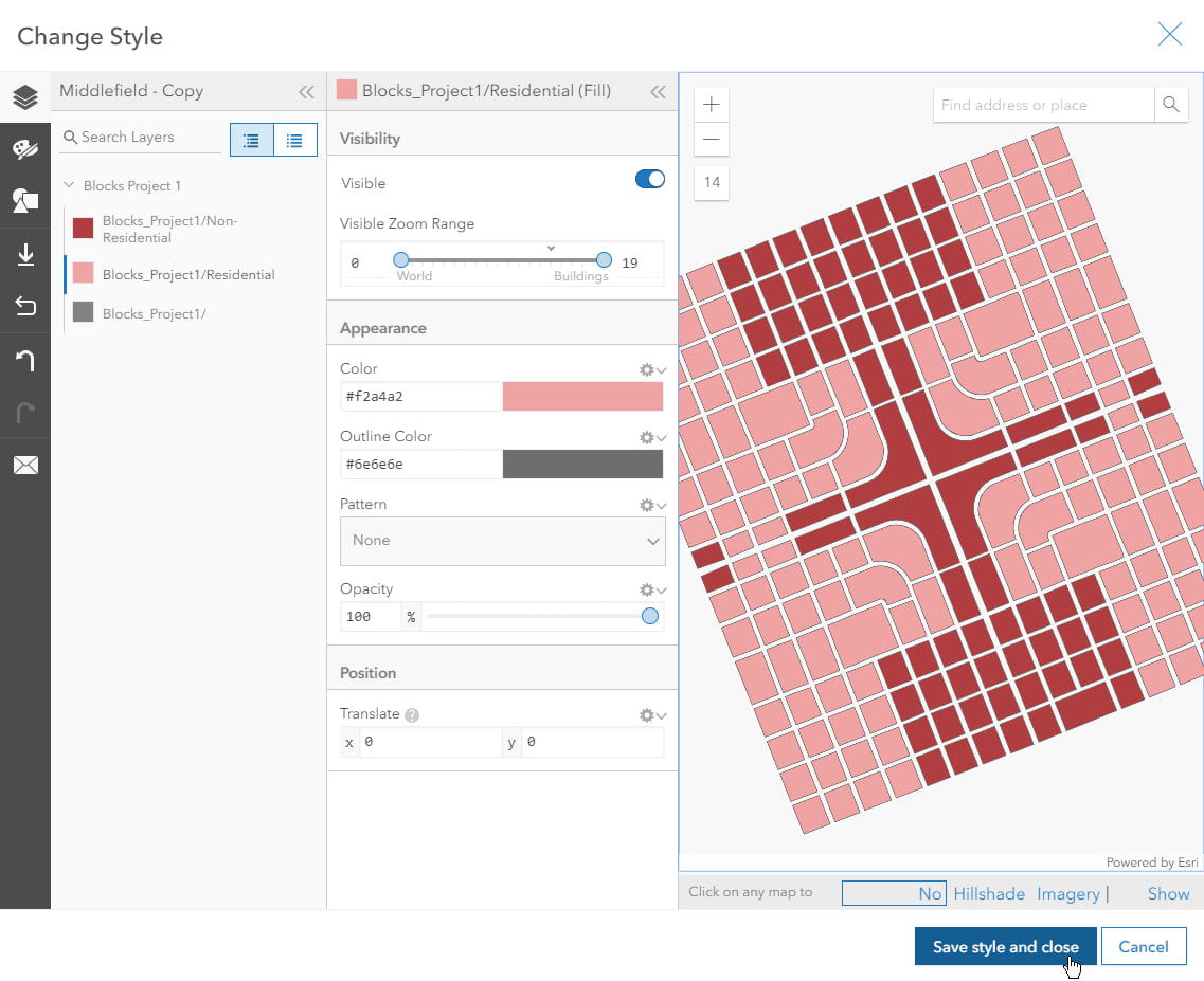
For more information about the Vector Tile Style Editor, including steps on how to customize your layers, take a look at Zara Matheson’s blog Edit Vector Tiles in Style from Map Viewer.
3D enhancements
In 10.8, scene layer performance continues to improve. The Scene Viewer within your Enterprise portal loads integrated mesh, 3D objects, and buildings up to four times faster. In addition, vector tiles have better rendering performance when navigating through a scene.
In Scene Viewer, there are new smart mapping styles so you can style your lines and polygons in new ways. You can create attribute-driven 3D extrusions from building footprints and color them by an attribute, such as property type. You can now display pop-ups on point cloud scene layers and even select individual points to inspect their properties to see attributes, such as elevation.
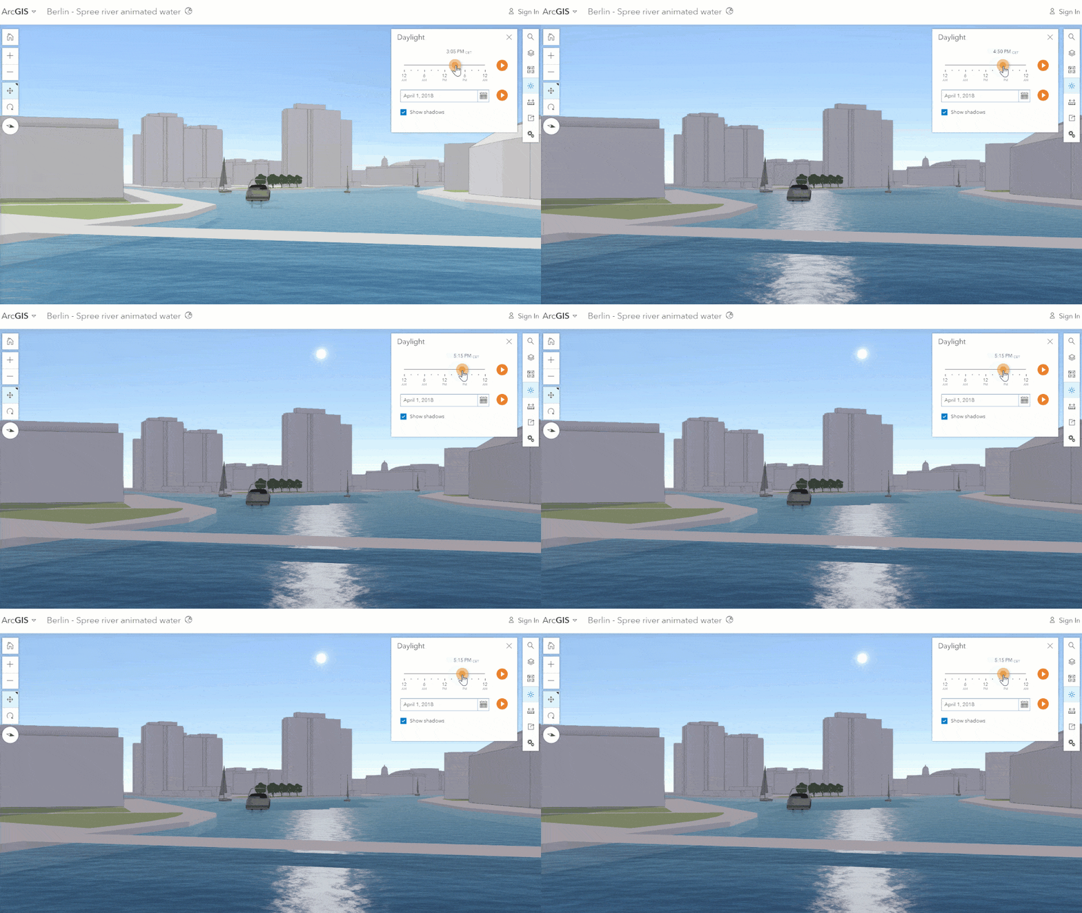
In your scenes, you can animate water (shown below) and take advantage of the new 3D models such as bicycles and fire hydrants to bring your scenes to life.
New configurable app templates
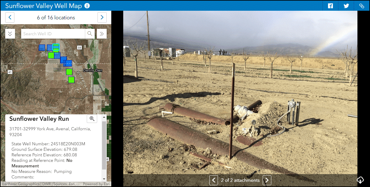
Three new configurable application templates are available in 10.8: Attachment Viewer, Nearby, and Zone Lookup. App templates make it easy to build your own app that focuses on a key workflow or theme. You may be familiar with these apps if you’ve seen or used them in ArcGIS Online.
Attachment Viewer highlights your data’s attachments right in your map, whether attachments are photos, videos, or PDFs. With an intuitive feature-by-feature browsing experience, it is a fast way to view all of the attachments related to your features. For example, click through all of the photos of a fire hydrant over the last 5 years to see if the paint has aged.
For more information about the Attachment Viewer, including steps on how to build an application, take a look at Kelly Gerrow-Wilcox’s blog, Introducing Attachment Viewer.
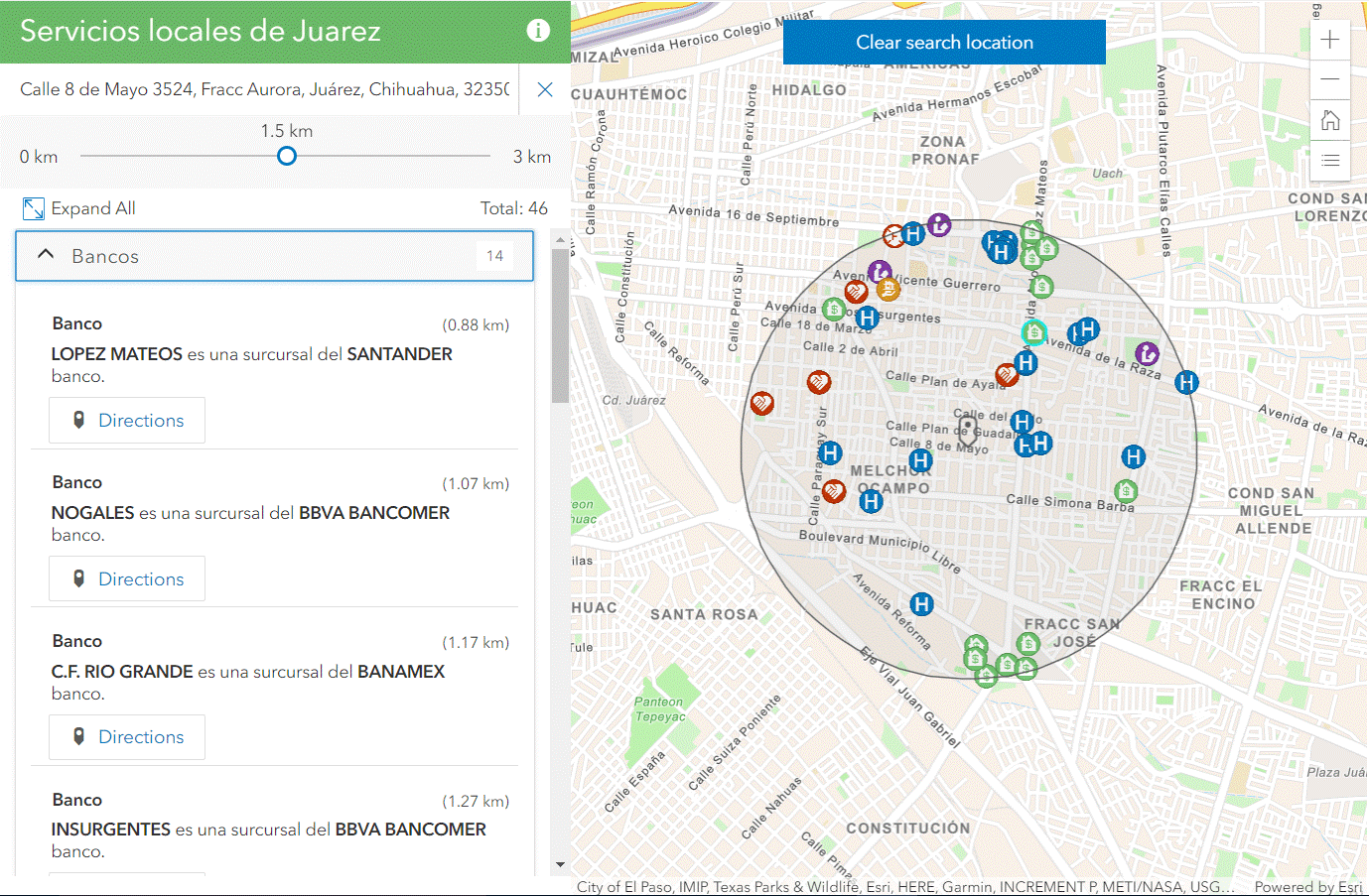
Nearby is also new at 10.8. This app helps discover what is nearby and how to get there. You can look up community resources, such as the closest bank, and even specify the distance you are willing to travel (it may vary depending on if you rode your bike or drove your car that day!)
For more information about Nearby, including steps on how to build an application, take a look at Beth Romero’s blog, Introducing Nearby, a new Configurable App.
The Zone Lookup template helps users determine whether the location selected falls within a predefined area, or zone, such a voting precinct. It also returns information about that particular zone to them, such as information about their zone’s polling station.
For more information about Nearby, including steps on how to build an application, take a look at Beth Romero’s blog, Introducing Zone Lookup.
New Web AppBuilder widgets
Enhancements to ArcGIS Web AppBuilder in 10.8 include new widgets, as well as widget and theme enhancements.
The highlights include the new Business Analyst widget, Query and Filter widget, and Public Notification. The Business Analyst widget generates infographics, in addition to classic reports. The Query and Filter widget allows for you to perform a query on a combination of date and time fields. You can even configure the Public Notification widget to add field names in the CSV download.
ArcGIS Enterprise Sites
ArcGIS Enterprise sites are a great way to showcase your maps, data, and apps to a wide audience using tailored websites and pages. The first update you may notice in ArcGIS Enterprise Sites at 10.8 is the updated user interface. There is now a streamlined display for creating and managing all of your sites. In this update, you will find that it is much simpler to create a new site, which now takes mere seconds.
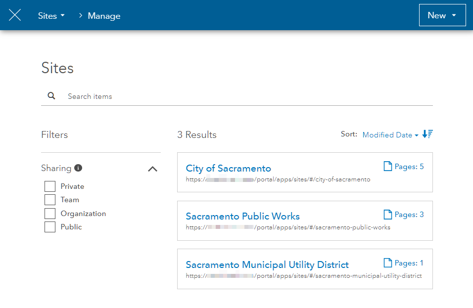
Also at 10.8, you can quickly see how many sites have been created, including their URL and how many pages are part of each site:
We are so excited about another new feature in ArcGIS Enterprise Sites: the ability to clone a site within your environment. This is great feature if you are looking to have a consistent design and layout across your sites. It also saves time; once you’ve created a fantastic site, you don’t have to start from scratch to create another just like it.
You can clone a site with a click of the button (below). This creates an entirely new site that looks exactly the same. You can then adjust your data, names, colors, move a few things around, or otherwise adjust in whatever way needed.

Lastly for sites, you can now assign site administrators on a per-site basis. When creating a site at 10.8 and up, two groups will be created behind the scenes. The Content group is for the items shown within the site. The Core Team group is to designate administrators of the site. Members of the Core Team group can edit and update the associated site.
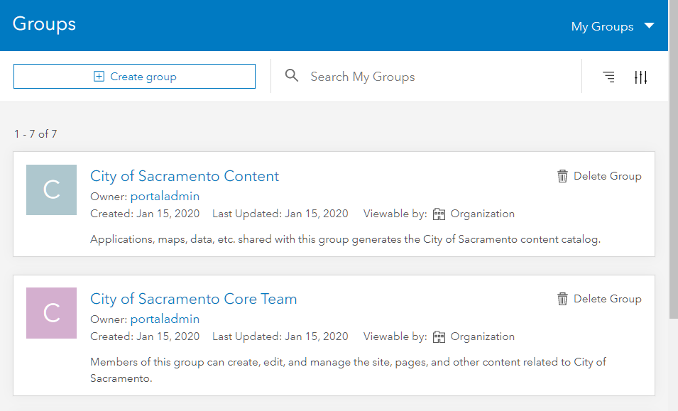
All of this provides more fine-grained control over who can edit which site. For example, Jill could be an admin of the Sacramento Public Works site but not the City of Sacramento site or Sacramento Municipal Utility District site.
Group enhancements
New options are available for groups within your Enterprise portal. As a group owner and/or manager, you can choose to hide the list of the group members on the Members tab of the group page when creating a new group.

This new functionality could be useful for a city that has multiple contractors from different companies in a group. Contractors can all have access to the same data within the group but don’t need to know contacts at other organizations. This option allows the city to protect the privacy of their contractors (group members).
In addition, administrative groups are now available, which ensures that members remain in the group unless they are removed by the group owner or a group manager.

Administrative groups are helpful when managing members, roles, and licenses. You can use administrative groups to filter members (example: assign Tracker for ArcGIS to all members in the northeast region).
There is an improved experience for inviting members to your group. You can now search members by name, user type, role, and group (which could be especially useful if you name your administrative groups after departments, offices, regions, or locations). This new experience is particularly helpful when adding many members to group at once.
Previously, when you were on the group page, you couldn’t add an item to the group. This meant you had to go out of the group and share from the item, content page, or other method. Now you can share directly into the group…from the group!

Server roles
There are exciting new features and updates for server roles at 10.8:
- ArcGIS GeoAnalytics Server (big data processing) now includes the new tool Find Dwell Locations, which identifies areas of idling with no movement. Find Point Clusters now includes time. For analysts who need to write their big data analysis back to their own storage, you can write to Azure blob storage in addition to other data stores supported in past releases. For a list of what’s new, check out What’s new in ArcGIS GeoAnalytics Server.
- For those getting started with ArcGIS GeoEvent Server (real time tracking), there is a new quick start guide available. When using GeoEvent, you will see enhancements to GeoEvent Manager’s service designer. Inputs and outputs are now stopped by default once created. Here’s more on what’s new in GeoEvent Server.
- ArcGIS Image Server (image and raster analysis) includes new multidimensional raster analysis tools and tasks as well as enhancements to OrthoMaker. For more, see What’s new in ArcGIS Image Server.
- In ArcGIS Notebook Server (Python data science and administration), there is a new Notebook Manager interface to manage your notebooks. You can also collapse sections within your notebook and schedule notebooks. For more information on what’s new in ArcGIS Notebook Server, be sure to check out What’s new in ArcGIS Notebook Server.
Documentation updates
There have been many fantastic updates to ArcGIS Enterprise documentation and resources. One example is the new applications landing page, which highlights the different types of apps that can be used with ArcGIS Enterprise. Other welcome additions include introductory topics like Services in ArcGIS Enterprise and Services and portal items. These and other topics are all included on the new Essentials tab.
Resources
Before we close out this blog, don’t forget about the wealth of additional information out there on ArcGIS Enterprise! Here are some links to top resources, including some recently updated favorites:
- ArcGIS Enterprise Quick Start Guide – new!
- ArcGIS Enterprise video – new!
- ArcGIS Enterprise: Architecting Your Deployment – updated
- ArcGIS Enterprise product page – updated
- ArcGIS Enterprise 10.8 Functionality Matrix – updated
- ArcGIS Enterprise documentation – updated
- Sign up for the ArcGIS Enterprise newsletter
- This Week’s Picks (check GeoNet for past and present picks!)
Ready to get started? Head over to the My Esri website for your licenses and software. Enjoy!


Article Discussion: