The December 2020 release of the ArcGIS Business Analyst Mobile App streamlines your workflows like never before, incorporating enhanced data and security features. The most recent release expands on capabilities built into the Mobile App’s DNA.
The ArcGIS Business Analyst Mobile App is designed to extend the power of Business Analyst Web Application when you’re on the move. Once you’re in the field, anything can happen. We’ve all been there, so we’ve focused on helping you address the unexpected.
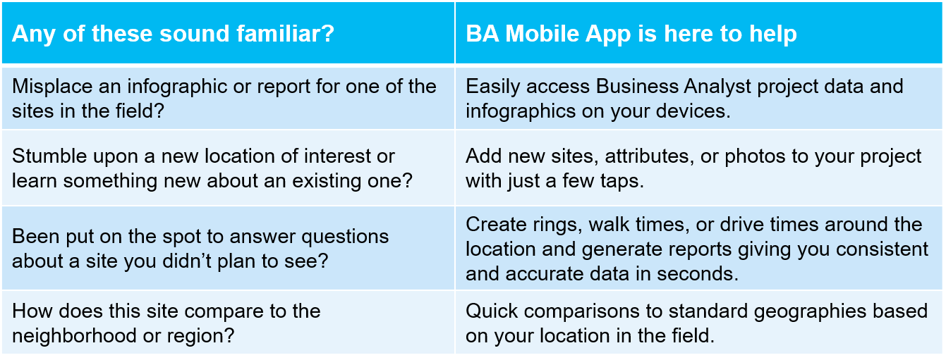
Easily access Business Analyst project data and infographics on your devices.
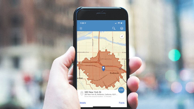
You can use the Business Analyst Mobile App to access projects you or your team have set up in the ArcGIS Business Analyst Web App, putting the power of BA in your pocket. Save some paper on printing infographics for each location and pull the data up on your phone or tablet. The best part: you’ve got access to all Esri and custom infographics to address questions that come up in the field.

As an example, you’ve planned a visit to seven potential locations for your new store or service center. You ran the drive time areas and printed infographics from the BA Web App before you hit the road. However, you misplaced the report for the fifth stop on the trip. You can pull the infographic up on your device to ensure all locations are viewed with accurate and consistent data.
Add new locations, attributes, or photos to your project with just a few taps.
Unplanned stops happen. You may stumble upon a newly available site or a brand-new grassroots community organization offering a service you’re interested in funding. With BA Mobile, you can create a new site and add it to a project. You’re immediately able to start evaluating the new site. In addition, you can update attributes or photos for locations in your project to capture new information you learn in the market.

Continuing our example, after the fifth stop you pass a newly available location near your sixth. You decide to make a pit stop. You’re able to add the site to your existing project so that you can begin evaluating the location in the same context as the rest of your locations. In addition, when you arrive at your sixth stop, you realize the photo you have is outdated. You can take a photo and add it to the site for use in reports.
Create rings, walk times, or drive time areas around locations and generate consistent reports in seconds.
Once you’re in the field, you gain a stronger sense of neighborhoods. Maybe you defaulted all locations to 5-, 10-, and 15-minute drive times in the BA Web App. You realize some of those locations may be in more walkable neighborhoods. You can generate walk times in the app and review the updated data based on your on-the-ground assessment of the neighborhood around that site. In addition, this functionality allows you to analyze your newly added locations with the same process as your pre-planned locations. This results in consistent evaluation of locations in seconds instead of needing to follow up later from your computer.

The new site you’ve added is in a highly walkable area, so you generate 5-, 10-, and 15-minute walk times around the site. A few seconds later, you select the infographic you’ve been reviewing for the previous locations to remain consistent in your assessment. At the sixth stop, you realize it’s not as walkable as you thought. Maybe it’s right next to a highway ramp and a railroad track. You update the areas to be drive time areas to better reflect how people will get there.
Understand neighborhood context using quick comparisons in the field.

Lastly, it’s often helpful to understand how a specific location or area compares to a reference area such as a County, City, or Core-based Statistical Area (CBSA). With BA Mobile App, you can run site comparisons against any standard geography included with Business Analyst, empowering you to put field location visits in a broader market context.
In our example, you want to know how much of the broader area is within reach of each location. In addition, you want to understand income levels or certain behavioral statistics about the local population to the larger area. You understand which location gives you the optimal access to population your new location will serve.
Download the app from Google Play or App Store today!
These are just a few ways you can unlock additional value of your ArcGIS Business Analyst license. Interested in speaking with us about how you or your organization are using the ArcGIS Business Analyst Mobile App? Reach out to us in the Esri Community for Business Analyst!


Article Discussion: