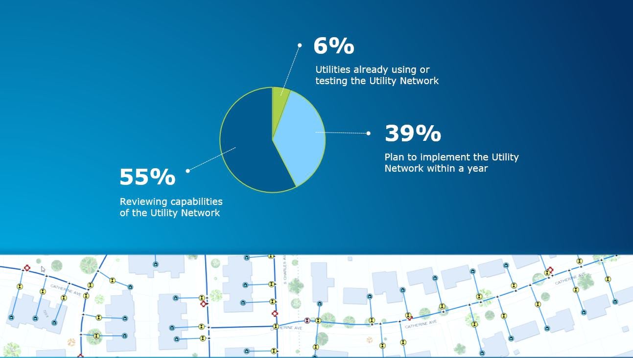
There’s been a lot of talk about the utility network over the last year. I’m sure you probably starting hearing about it several years ago, but within the last year there has been an increase in interest. This is because water utilities are starting to understand what the utility network is and why they would want to use it.
In response to this interest, the Esri water team recently hosted two webinars focused on the utility network. These webinars resulted in a lot of questions! In response to these questions, I have identified a few hot topics and provided some answers below.
Topic One—Licensing
ArcGIS Enterprise is required to implement the utility network. The utility network is enabled with an extension to ArcGIS Enterprise: ArcGIS Utility Network Management. This extension is available with ArcGIS Enterprise 10.6 through 10.7.1. You will also need a Standard license of ArcGIS Pro.
Topic Two—Data
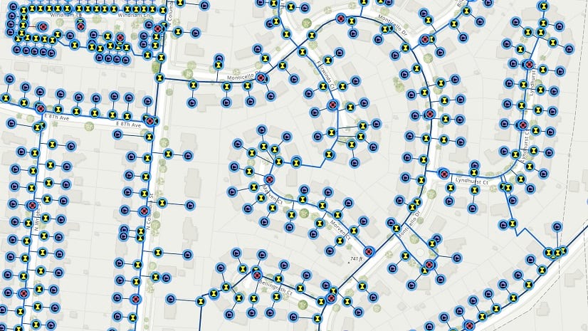
The utility network implemented with the ArcGIS Utility Network Management extension creates a new data type in ArcGIS. This data type provides a robust foundation for scalable modeling of all utility assets. It has been designed to handle a large volume of data. However, careful consideration should be done to appropriately scale resources.
The utility network is services based, but data still resides in a relational database. Databases that support the utility network include SQL Server, Oracle, PostgreSQL, and SAP HANA. For more information, please reference the system requirements.
Topic Three—Migration
There are several things to consider prior to implementing the utility network.
First, you need to have a good understanding of your current data: feature classes, domains, subtypes, attributes, annotation classes, and relationship classes.
Second, you should be familiar with Water Distribution Utility Network Foundation templates and asset packages. Esri provides templates and configurations as a starting place for water distribution, sewer, and stormwater utility networks. These include data models, common assets, and rules to define connectivity and behavior in the form of an asset package.
Assets packages offer a quick way to configure a utility network. They use a file geodatabase to model the schema, properties, related layers and tables, and data of a utility network. You can further modify the provided asset packages to better reflect your operations and the way your system is constructed. You can also use the asset packages to load existing data into a utility network.
Esri recently released the Water Distribution Utility Network Data Loading template, which streamlines the workflow for loading existing geographic information system (GIS) data into a Water Distribution Utility Network Foundation template. Templates for wastewater and stormwater specific data loading workflows are still being developed.
For the best results, prepare your data for the utility network. Do an inventory of your data. Perform attribute and geometry checks to ensure that you have clean data—no missing assets, duplicate or disconnected lines, features outside your service area, etc. Esri’s ArcGIS Data Reviewer can help with this.
Third, it is strongly recommended that you establish a staging environment for fully testing the utility network.
Not Ready for the Utility Network?
Some organizations may not be ready for the advanced capabilities of the utility network. As an alternative, there is an ArcGIS template called Water Distribution System Foundation. It configures ArcGIS Online to act like a cloud-based GIS for water distribution but does not include any network capabilities. It deploys a data model that is aligned with the Water Distribution Utility Network Foundation data model, making it easier to transition to the utility network in the future.
If you missed the utility network webinars or just want to see them again, click the links below:
- Introduction to the Utility Network for Water Utilities
- Water Utility Workflows Using the Utility Network
By Christa Campbell
Water Specialist, Industry Solutions


Commenting is not enabled for this article.