The Aircraft Parking app gives airport operations teams a shared, real-time, map-based parking plan they can update in the field using true-to-scale aircraft shapes, configurable attributes, and audit-friendly history to manage diversions, seasonal surges, and special events.
When an unplanned wave of commercial flights diverts into your airport due to bad weather, or when a major event fills the GA ramp with private business jets, the operations team makes decisions fast – Right now, where can the aircraft park? How long will it be here, and how does that impact the rest of today’s plan?
Across airside ramps, one operational challenge appears repeatedly: parking space changes faster than spreadsheets. Plus, paper and radio coordination tend to break down precisely when pressure is highest. Esri’s Aircraft Parking App addresses these gaps by giving airport teams a shared, map-based parking plan; a living digital twin of activity they can update in the field and view across the organization in real-time and throughout time.
Ramp Space Changes Faster Than Spreadsheets
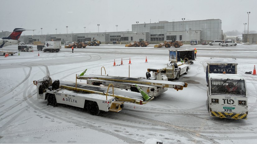
In addition to regular, scheduled flight operations, surges in aircraft activity caused by weather, congestion, special events, maintenance disruptions, and other unexpected conditions play havoc. When aircraft arrive without warning, teams must quickly identify appropriate gates and, when needed, overnight or extended parking locations. Anytime aircraft demand exceeds available gates and parking spaces, planners must use creative parking solutions, including designated remote stands, taxiway closures, or other approved paved areas.
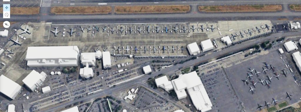
The challenge is not simply knowing aircraft are coming, but maintaining a real-time view of ramp activity, occupancy, available space, and the best alternative when plans change. The need is more than simply knowing that aircraft are coming; it is maintaining a live picture of what is already on the ramps, what space remains available, and what the next best option is when the original plans change.
Traditionally, most operations teams rely on verbal communication, whiteboards, spreadsheets, and paper – tools that lack a map-centric view. Because location is central to airside operations, after learning how these activities are managed now, I questioned why Geographic Information Systems (GIS) technology was not being used to create and visualize parking plans, show where aircraft were parked, or track parking history.
I decided there was a better way to build and maintain dynamic parking plans and boost situational awareness than on a napkin. So here is what I did.
How the Parking App Grew Wings
As a kid, I loved flying and building model airplanes. After I grew up, I was fortunate to put my love of aviation to work; I started flying for the airlines. As with any profession, flying has its ups and downs. All too frequently, things did not go as planned; I experienced first-hand the disorder and delays that come along with irregular ground operations when things unravel. Thinking about my own experiences as a pilot and after listening to airports struggling to manage this, I had an idea.
I began by downloading digital 2D models of commercial and military aircraft commonly found at airports. In ArcGIS Pro, I converted the models into polygons, scaled them to their actual dimensions, combined them into a single layer, and published the layer as a georeferenced hosted feature service.
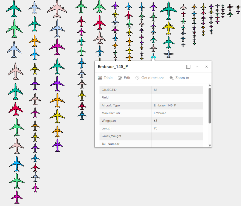
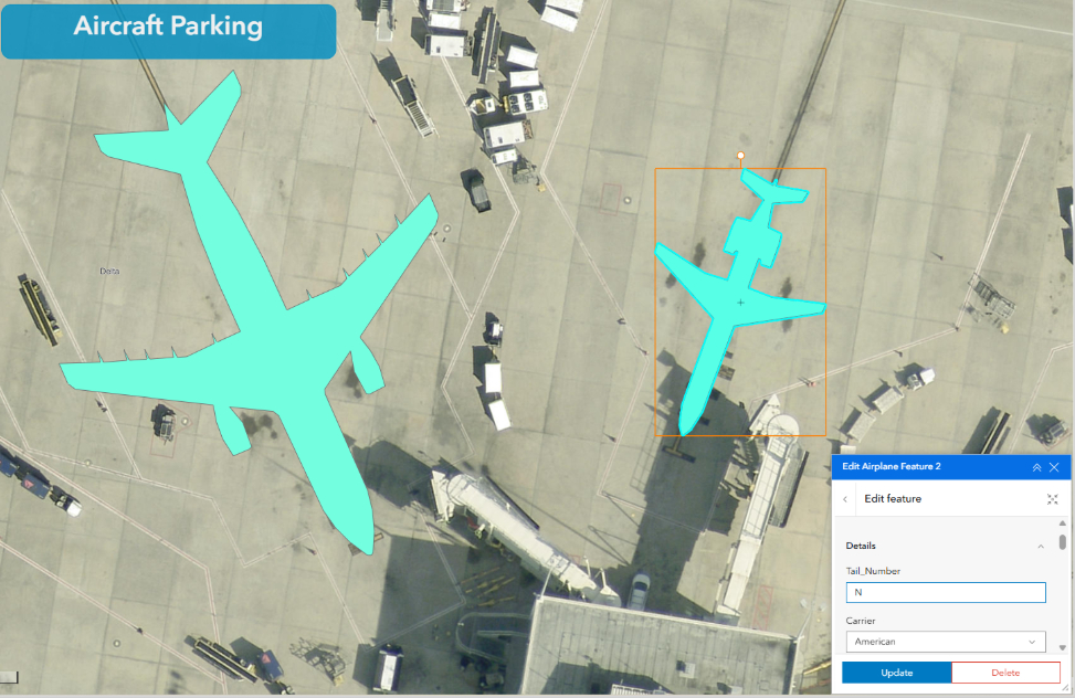
I added the aircraft feature service layer to a web map and used the Esri imagery basemap from the Living Atlas as a reference. In edit mode, I selected an aircraft from the list and placed it where it would fit. I then configured an Editor widget and workflow in ArcGIS Experience Builder that lets users add, move, and rotate aircraft alongside other planes—much like assembling a puzzle. To preserve each aircraft’s true dimensions, I disabled scaling and shape modifications.
I also configured a responsive app that lets field operations teams place the true-to-scale aircraft silhouettes on a digital map using a web app or with their mobile device, add photographs, attributes to track arrival time, length of stay, and aircraft-based daily fees, color-code aircraft by airline, category, or operational status. This app fed an ArcGIS Dashboard that decision-makers would use to understand existing parking conditions and to explore how many different planes might fit within a defined area. This digital twin of parking activity supported advance planning and real-time decision-making during severe weather, diversions, special events, and other high-demand situations.
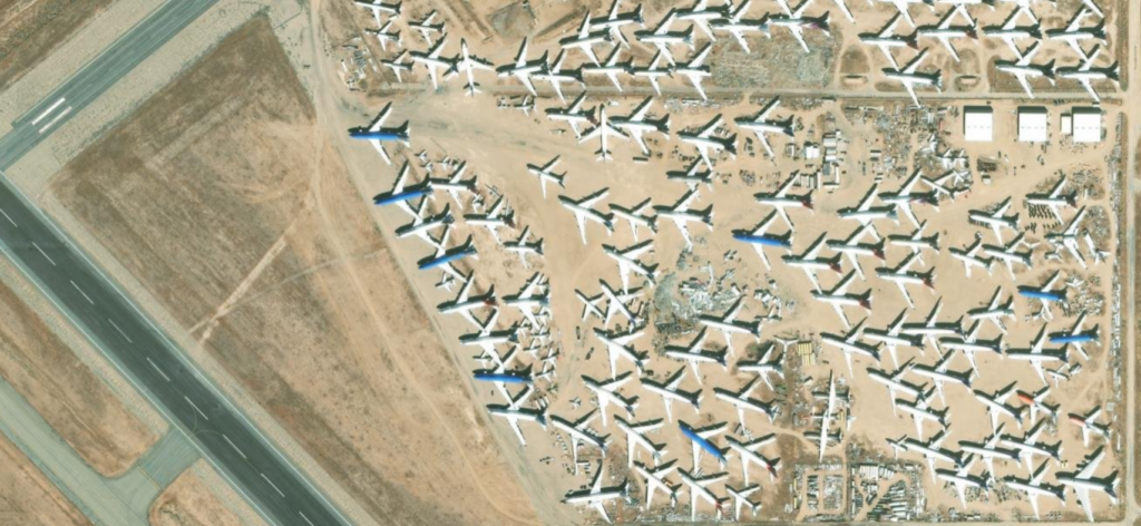
I did all this during covid, when air travel was severely restricted, when airports were scrambling to capture lost revenue where every they could, and when airlines were temporarily mothballing much of their fleet as the industry was being put on ice. I knew some airports were renting space on their airdromes, almost anywhere they could park airplanes while covid ran its course. Maybe they could use this tool to build and maintain their own optimized parking plans during the pandemic and afterwards. This became my proof of concept for a GIS-based Aircraft Parking App.
The Solution: a shared “Aircraft Parking Plan” on a map
The core idea is straightforward: treat aircraft parking as a living plan that the entire operation can see and update. Instead of relying on scattered notes or individual awareness, the app provides a shared map view showing where aircraft are actually parked, along with the operational context needed to manage them over time (short stays, overnight, extended periods). In other words, it’s not just a map of aircraft; it’s a location-based plan for how the airport is using its ramp space over time and as real-time conditions change.
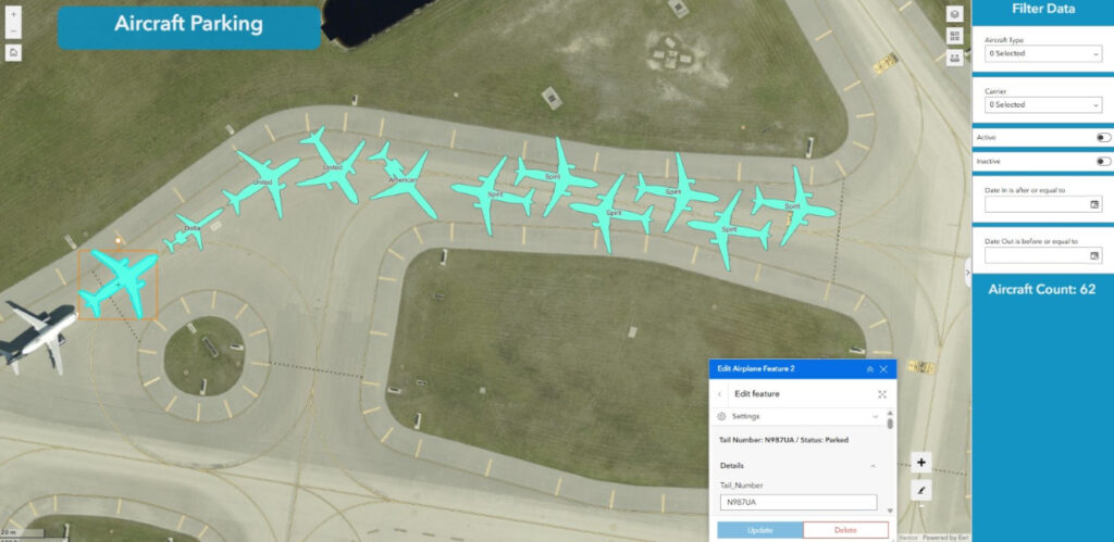
To maintain uninterrupted oversight of airside activity and keep continuous, vigilant situational awareness, Airfield operations personnel use the app to build parking plans, see, track, and understand where all aircraft are parked at all times.
Field Updates = Organization-wide Situational Awareness
The Aircraft Parking app’s workflow intentionally supports both ramp/field staff and office-based decision makers:
- Field/mobile placement: Staff in the field can pin precisely where an aircraft is parked right on the map while they’re directing aircraft to locations.
- Shared visibility: The Parking App provides situational awareness to the broader organization, so multiple stakeholders are looking at live digital twin, one authoritative “source of truth.”
- Operational attributes: The app supports both standard and customer defined fields including date in/date out, status, airline, and other fields that match local workflow.
- Attachments for context and auditing: Users can attach photos and documents (including PDFs such as incident reports) to a specific aircraft record.
- History over time: Rather than losing information when an aircraft departs, records can be retained through an active/inactive pattern, enabling historical review for auditing and billing.
Not just Map Symbols – True to-scale Aircraft Representations
Instead of generic pins, aircraft appear as true to-scale 2D shapes/polygons. That matters because parking isn’t only about “a spot” it’s about clearance, buffer distance, wingspan constraints, and whether moving one aircraft limits or blocks options for parking the next plane.
A growing aircraft reference library – To eliminate information gaps, the app uses a large reference layer that supports a vast array of aircraft types. With scripted workflows, that list can be expanded to include additional commercial, military, and business aircraft. If an Ops Agent encounters a non-indexed aircraft, the GIS Team can integrate the new aircraft shape (data) into the library, ensuring the tool remains a “living” resource that scales with the airports’ operational needs.
Configurable data fields – Different airports track different details. The app supports custom fields, so the data model can match how a specific operation runs without forcing everyone into a one size fits all form.
Attachments (photos + PDFs) – Operational reality often includes exceptions. Photos and documents attached to an aircraft record can support auditing, communication, and after-action reviews, especially when something unusual happens.
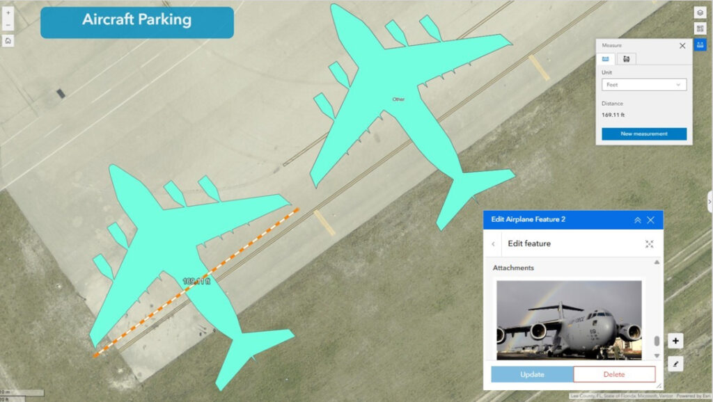
The Editor widget for faster editing and smoother workflow – This tool supports creating and updating the aircraft record (location/orientation and attributes) with a key constraint: users can place, move and rotate aircraft, but scaling is disabled. The value here is speed and consistency; where users don’t need to “draw” aircraft from scratch. That prevents accidental distortions and preserves the integrity of true to-scale visualization.
Does It Fit – Because aircraft are represented to-scale, one natural extension is using the app as a visualization tool for “gate fit” questions.
Deployment options: ArcGIS Enterprise or ArcGIS Online
The Aircraft Parking app can be deployed in either ArcGIS Enterprise or ArcGIS Online, but the packaging/hosting approach differs:
- ArcGIS Enterprise: widgets are deployed into the customer’s Enterprise environment and hosted on a customer-maintained web server, then referenced and used within ArcGIS Experience Builder.
- ArcGIS Online: the application is configured using ArcGIS Experience Builder Developer Edition, hosted on a customer web server, and referenced back into the customer’s ArcGIS Online organization.
In both deployment models, the technical configuration effort is manageable. A successful implementation depends on close coordination among airport IT, GIS, operations, and any hosting service providers, particularly when establishing and maintaining the required web server environment. Deployment timelines vary according to local infrastructure, security review, governance, data readiness, and stakeholder availability.
Additional Value: Diversions, Special Events, and More!
The Parking App’s value shows up in both unplanned and planned surges. Diversions require quick decisions: gate availability now, parking availability later, and the flexibility to adapt when the “expected short stop” becomes an overnight stay. Effective preparation is crucial for accommodating an influx of private business jets during major events, such as the Super Bowl, when parking becomes limited. The app allows ramp managers to organize a parking strategy ahead of time by allocating specific aircraft types to designated sections.
Beyond commercial and general aviation (GA) airports, the same approach can support military installations with large-scale parking needs, aircraft manufacturers managing aircraft staged on ramps for extended periods, maintenance organizations, and other operations that need to know where an aircraft is parked and how that location affects the broader plan.
ROI: Why You Should Care
As your own Aircraft Parking app moves from initial deployment into sustained operations, its return on investment (ROI) can be evaluated and documented. The value generally falls into three categories:
- Time: faster decisions and fewer coordination cycles when everyone can see the same picture
- Safety: better spatial awareness and planning around buffer/clearance constraints
- Money: potential to support parking fee and overnight fee workflows through date in/date out and location aware tracking
Conclusion
Esri’s GIS-based aircraft parking tool is more than a digital map; it is an innovative living digital twin of ramp activity that improves airside efficiency, safety, collaboration, and revenue. By providing a shared operational view and adaptable, location-aware workflows, the app helps airports optimize ramp planning, strengthen situational awareness and audit tracking, enabling staff to respond more effectively as conditions change.
“A mile of highway will take you a mile. A mile of runway will take you anywhere!“.