From Airport to Staging Yard: Using ArcGIS to Plan, Operate, and Manage a Construction Laydown Yard at an Active County Airfield
The United States is in the middle of a transmission infrastructure buildout unlike anything seen in decades. New high voltage lines are being routed across the US to move power from renewable generation sites to load centers, to supply the growing cluster of AI data centers, and electrification projects. The queue of proposed projects keeps getting longer. Projects of this scale demand more than engineering expertise. They also require secure, level, utility-served staging areas near construction corridors, with enough space to store large amounts of equipment and materials.
Finding that space is harder than it sounds. You need acres, not lots. You need security and access control. You need power, water, and telecom. You need proximity to construction corridors, line routes, and to highways. And you need it all on short notice.
That combination of requirements is exactly what an airport already provides, and a GIS based approach is what turns a leased section of tarmac or bare land into a fully managed, documented, and reusable operational site.
Why Airports Work as Construction Laydown
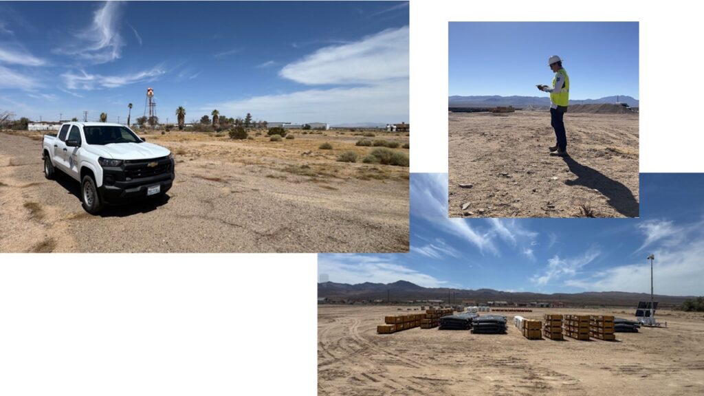
The staging yard for this project is located at an active county owned airport in the Mojave Desert, roughly midway along a high voltage transmission corridor. It is not an abandoned facility; it is an operational airport with existing fencing and gate systems, onsite power and telecom, and direct access to a state highway.

For a major 100-mile high voltage transmission project in the Mojave Desert, a trusted Esri Partner, GIS Surveyors worked with the project team to evaluate and ultimately lease approximately 40 acres of airport property as the primary staging yard.
The airport offered what generic industrial parcels cannot:
- Established perimeter security with existing fencing and controlled gate access
- Flat, paved, or compacted surfaces already suited for heavy equipment and material storage
- Existing overhead electric, telecom, water, and gas infrastructure documented on the site
- Highway connectivity for oversized loads and high frequency crew transport
- A county owner motivated by community benefit and project activity
That last bullet point matters for site selection economics, but it also matters for the airport’s balance sheet. A multi-year lease of 40 acres to a major infrastructure contractor represents meaningful non-aeronautical revenue from land that would otherwise sit idle. For airports operating on thin margins with deferred capital needs, that revenue is important. It is a genuine financial asset. Airport executives considering this model should note that non-aeronautical revenue generated on airport property is subject to FAA revenue use requirements under federal grant assurance obligations. Lease revenue must be used for airport purposes, and any agreement should be structured in coordination with legal counsel and, where applicable, the FAA regional office. This is not an obstacle; it is a standard part of doing business with airport land, but it is a step that requires early attention in the leasing process.
The governing agency that oversees the airport also holds permitting authority over many of the activities that happen at a laydown yard, a compounding advantage that should not be overlooked during site selection. For airport operators, one non-negotiable requirement is that any land use on airport property must be managed in a way that does not compromise safe, compliant flight operations. That means the GIS site plan must account for runway protection zones, approach and departure surfaces (OIS), taxiway object free areas, and wildlife attractant risks from open material storage.
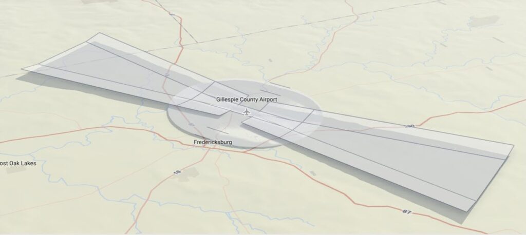
This project staging area was deliberately positioned on non-aeronautical land away from active movement areas. The GIS layer structure included operational boundary lines to keep the construction footprint clearly delineated and away from airside operations. That spatial documentation is not just a planning convenience; it is the record that demonstrates to governing authorities including the FAA, to the entity that manages the airport, and to the airport insurer that the activity was properly controlled.
What GIS Adds: From Land to Operating System
Leasing the land is the starting point. Managing it can be a challenge without Geographic Information Systems (GIS). A 40-acre laydown yard for a multi-year infrastructure project involves hundreds of features, dozens of contractors, continuous movement of materials and equipment, utility connections and modifications, access route designations, safety zones, and regulatory documentation requirements. Tracking all of that with spreadsheets and hand drawn plans creates gaps, conflicts, and delays.
GIS Surveyors built the primary staging yard using three core Esri tools working in combination. ArcGIS Field Maps was used to capture existing site conditions, walking the airport property to record utility points, fencing, structures, and hazards as georeferenced features with photos and attributes. ArcGIS Pro served as the desktop platform for all data management, site layout design, analysis, exhibit production, and publishing. Using ArcGIS Pro, the team published authoritative layers to ArcGIS Online, making the site data accessible to the project team directly through the internet.
ArcGIS Experience Builder was used to configure a stakeholder review portal, giving the airport, prime contractor, and project owner a common, shared web interface to view the site plans, explore map features, and submit feedback; without needing any GIS software of their own. Every element of the site from individual cable reels, guard shacks, to location of temporary utility poles was mapped, attributed, and managed as GIS layers that were accessible through ArcGIS Online.
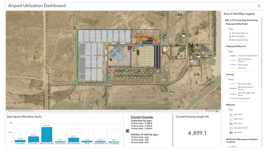
What Was Mapped
The primary staging yard contained key layers included:
- Warehouse Management System (WMS) named locations, laydown lots, receiving areas, kitting zones, staging zones, shipping containers, and temporary offices
- Materials, cable reels, dumpsters, and a generator, each placed as a georeferenced point
- Equipment parking and handicap accessible spaces
- Proposed utilities – new and temporary electric line segments, telecom lines, water lines, and gas connection, plus new temporary poles and water backflow preventer
- Existing utility points including power poles, telecom poles, transformers, hydrants, and assorted gas and water infrastructure
- One way and two-way internal traffic routes
- New, existing, and temporary perimeter and interior fencing
- Occupancy zones delineating which parts of the yard belong to the transmission owner, the prime contractor, and subconsultants
Each feature included attributes such as type, status, size, zone assignment, last editor, and timestamp. These details support accountability, conflict checks, and reporting without requiring staff to visit the site for routine information.
The Common Operating Picture
One of the core values of this approach is that GIS creates a single authoritative view of the site shared with the airport operator, the prime contractor, subconsultants, and the project owner. Regardless of technical background, the Experience Builder portal gave every stakeholder a live, authoritative window into the site. When a utility connection changed, a zone was reassigned, or a new temporary structure was added, updates were made once in ArcGIS Pro, published to ArcGIS Online, and immediately visible to everyone through the portal.
This saved time and reduced the coordination that typically compounds on large multi-party construction projects; fewer calls to confirm where something is, fewer conflicts between crews who didn’t know a zone had changed, and faster resolution when something needs to move.
A Second Yard, Mapped the Same Way
The project also required a second staging yard farther along the corridor, near the California-Nevada border. It was mapped using the same methodology. Built on the same GIS framework, the smaller secondary yard used a consistent schema, allowing data from both sites to be combined for project-level reporting.
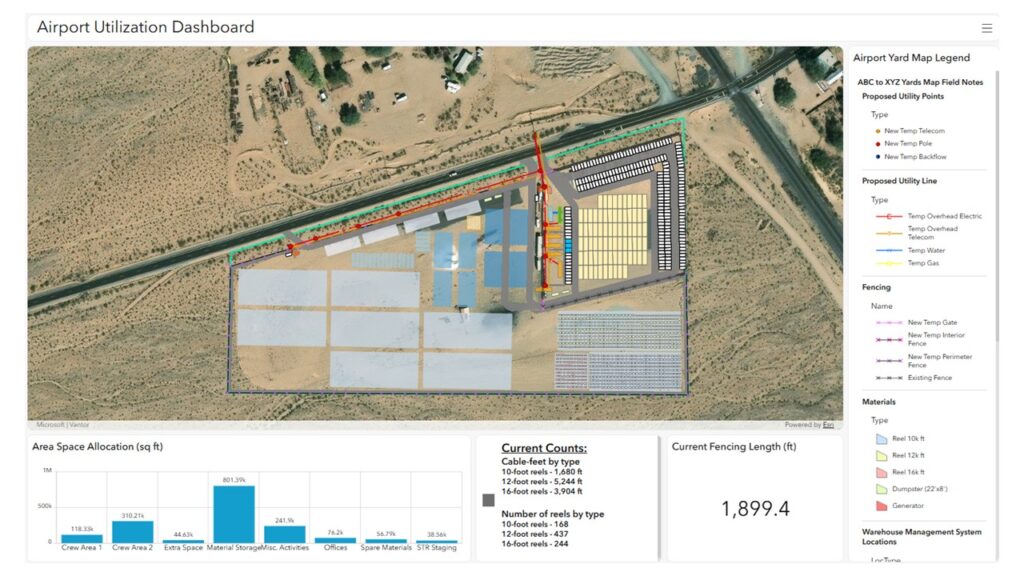
The template can be quickly adapted for other projects and sites with minimal effort. This cross-site consistency is a key advantage of developing laydown yards as reusable GIS products rather than one-off site drawings.
The Airport as a Repeatable Infrastructure Asset
A less obvious benefit of using airport property as a laydown yard emerges when the project ends. When a contractor completes a multiyear transmission project and demobilizes a temporary yard on leased industrial land, the site typically returns to its previous condition, and the contractor takes the operational documentation with it.
When that yard is on airport property and when the entire site has been built and documented with ArcGIS, the airport retains a spatially complete record of what was built, where utilities were connected, how traffic was managed, and what zones were used for what purposes. That is an asset that also helps minimize risk. Pre and post condition documentation in GIS gives the airport a defensible baseline if a contractor disputes damage claims at demobilization. It supports lease compliance enforcement. Without requiring airport staff to generate it themselves, the system satisfies documentation requirements that come with federally obligated airport land.
The airport can use it to:
- Lease the same footprint to the next contractor with a ready-made site plan and utility map
- Redeploy the infrastructure for its own capital projects without starting from a blank slate
- Offer a documented, GIS managed site as part of a proactive pitch to attract future infrastructure projects
- Preplan the site for emergency or disaster relief staging using the existing layer structure
Entities that own airports and hold regional permitting authority are well positioned to develop this capability proactively. The combination of available land, existing infrastructure, site control, and permitting leverage makes airports natural candidates for what amounts to a pre-qualified, ready to activate logistics hub for large infrastructure builds.
Airports that develop and document this capability now will be prepared to compete for the next wave of projects. Those that delay risk losing lease revenue, local jobs, and long-term site investment as contractors choose private land in other jurisdictions.
What This Looks Like in Practice
The primary staging yard was not just a site plan. It was a fielded GIS product. The layer structure reflects the kind of operational detail that only becomes manageable when it lives in a spatial data environment:
Every zone in the yard carries unique IDs for laydown lots, shipping containers, and so on across every feature type. Those IDs mean any location can be referenced unambiguously in a work order, a safety report, or a crew briefing without someone having to walk the site to explain what they mean. Proposed utility connections are tracked with status attributes and date/time stamps for edit tracking, so the project manager can see immediately what has been installed, what is still pending, and who made the last change.
Traffic routes are mapped as named features including the materials route, general traffic route, patrol route, and pit lanes rather than as painted lines that may be ignored or forgotten. Occupancy zone polygons assign each yard to the appropriate organization: the transmission owner, prime contractor, or subcontractor, allowing the data to support access control and coordination without requiring constant on-site oversight.
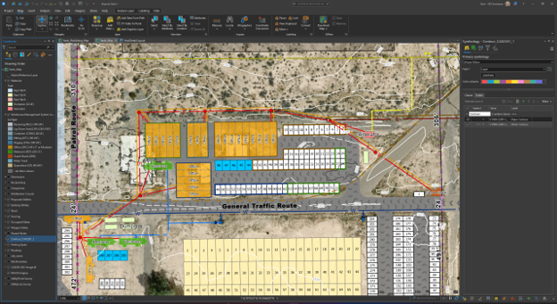
Every one of those details existed on the ground regardless of whether it was in GIS. The difference is that with ArcGIS, it was visible, searchable, updatable, and reportable from the field or from the office.
The Broader Opportunity
This project was associated with one transmission line. The buildout currently underway across the Unted States involves many comparable projects, each requiring similar logistics infrastructure; yet most project teams are solving the laydown problem from scratch each time. Airport property is an underused resource that already meets many contractor requirements, giving airport-owning jurisdictions strong reasons to make it available.
What has been lacking is an operational framework that makes these sites easy to assess, activate, and manage. GIS provides that framework. ArcGIS turns an airport lease into a spatially documented, operationally managed, and reusable infrastructure asset. It gives project teams the visibility they need to run a complex yard. It also gives airport operators something they can use long after the contractor leaves.
Unlock the Full Potential of Enterprise GIS
This project demonstrates that the real value of GIS extends well beyond mapping. It transforms airport property into a managed, documented, and reusable business asset that continues delivering value long after a project is complete. To get the guide, please visit How to Set the Foundation of Your Intelligent Airport and discover your flight path to enterprise GIS success.
Walk with your eyes turned skyward