Skip to Content

Transportation Equity

Oakland Department of Transportation map that shows disparities, in the foreground a street with a green painted bike lane

Building a more equitable transportation system

Targeting transportation investments for greater inclusion and accessibility

Reliable and affordable transportation is critical for accessing educational opportunities, jobs, housing, health care, and other services that enable economic prosperity, physical and emotional well-being, and social mobility. GIS provides powerful analytical and mapping tools to help you better understand community needs and mobility requirements, apply an equity lens to your project selection and prioritization process, and design and deliver equitable transportation resources to all.

Addressing equity in transportation

Discover how GIS can foster a better understanding of your community's transportation needs and help you design and build a more equitable transportation system.

Understand your community

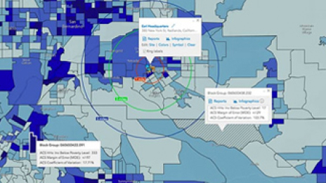
Understanding precedes action. Gaining deeper knowledge about your community is necessary to understanding transportation needs and advancing greater accessibility. Identifying where economic and mobility challenges occur is a first step in addressing equity. Esri's rich data sources include demographic and spatial data down to a granular level to help you analyze specific populations in your community and track changes over time. These GIS tools allow you to visualize factors such as where low-income seniors, residents in severely rent-burdened households, and people with disabilities live.

a map displays gradient shades of pink to indicate unknown disparities in an area

Operationalize equity

Programs that address equity will be unique to each community. GIS helps you understand the different mobility challenges faced by different groups within your community, helping tailor targeted programs to bring greater accessibility and invest in people and places according to their needs. Whether issues relate to lack of mobility options for getting to schools, jobs, health care or other services, GIS can help you create comprehensive measures designed to make transportation systems more inclusive and better meet the needs of everyone in the community.

Transit propensity map displays disparities in service areas

Target equitable investments

Armed with a comprehensive analysis of your community and the diverse transportation requirements of various groups and households in your community, you can better understand where to make infrastructure and service investments to make your transportation systems more inclusive and equitable. Achieve community equity goals to ensure that everyone has access to safe, dignified, frequent, and affordable transportation.

Transit propensity map identifies areas in the study area where there are populations with the greatest need for transit

Case Study

Increasing equity by improving community mobility

Centralina Regional Council and Charlotte Area Transit System use GIS to facilitate transportation and access to services in a diverse region.

Read the case study

Contact sales