ArcWatch: GIS News, Views, and Insights
June 2011
A Surge of Flood Map Apps
By Karen Richardson, Nick Miller, and Carla Wheeler
Esri
When disaster strikes, web mapping applications serve as a valuable online resource for sharing vital and timely information about the crisis. That was the case this year when the Star Tribune newspaper in Minneapolis, Minnesota, published an interactive online web map created using Esri technology to help inform readers about the spring flooding in western Minnesota and eastern North Dakota. Read the article.
Half a world away in Australia, Brisbane City Council (BCC) worked with ESRI Australia Pty. Ltd. to create two online web mapping applications to share information about the area's deadliest floods in more than 35 years. One app was geared toward government agencies and included data to help officials coordinate an emergency response; the other kept citizens updated with the information they needed, such as where flooding was expected to occur and the location of evacuation centers. Read the article.

This interactive web map with flood news and information was published at StarTribune.com.
Tip of the Month
Share a Common Map for Your Organization
Get step-by-step instructions on how to share a common map for your organization to use with desktop, web, and mobile applications. Read this tip.
Connect with ArcWatch
ArcWatch is published monthly by Esri and contains GIS news, practical advice, and updates about the company's software and events. To submit article ideas, e-mail editor Carla Wheeler at arcwatch_editor@esri.com.
Blog Spotlight
Heading to the 2011 Esri International User Conference? Get helpful tips about what to see and do there on the UC Blog. For example, read more about the GIS Managers' Open Summit.
One-Stop Mapping Center
 Do you need to know how to choose the right symbols for your map; select the appropriate geographic transformation; or decide which digital elevation model (DEM) dataset to use, given your map scale? Esri Mapping Center can help. In this article, Aileen Buckley, team lead for the center, offers a tour of this free online resource, which is dedicated to helping people make great maps with Esri's ArcGIS software.
GPS Live in ArcGIS Explorer
 You can now view GPS data in real time using the latest release of ArcGIS Explorer Desktop, Esri's free GIS viewer. By connecting your GPS-enabled device to ArcGIS Explorer Desktop, you can display your current location (whether on foot or in a vehicle) along with waypoints and tracks. Read the article.
Mapping Maryland's Future
In a recent speech to the US Green Building Council, Maryland Governor Martin O'Malley talked about the importance of using GIS "smart maps" to improve life in the state. He cited ways in which GIS was being used for crime analysis and tracking the cleanup of Chesapeake Bay. Watch the video or read a transcript of his talk.
Who's Who in GIS for Utilities?
Read the report MarketScope for Energy and Utility Geographic Information Systems from Gartner, Inc., the leading provider of research and analysis on the global IT industry. Find out which GIS companies are meeting the needs of the utility industry and learn why Gartner gave Esri a Strong Positive rating, the highest possible.
Newsroom
Mapping Severe Weather
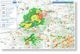 Dozens of tornados, hailstorms, and heavy rain have recently slammed the United States. In Joplin, Missouri, for example, a tornado devastated much of the city, killing more than 130 people. Esri's Severe Weather Map shows how feeds from the National Weather Service; data from Televent; and crowdsourcing information from Twitter, YouTube, and Flickr all combine to tell the story of these unfolding events. Learn more about this application.
GIS for Emergency Response
Wilson Fire/Rescue Services in Wilson, North Carolina, uses Esri's ArcGIS technology in multiple ways, including for analyzing traffic accidents and planning annual commercial building inspections. Read the article.
Managing Street Sweeping with Geospatial Technology
In Maricopa County, Arizona, GPS data from on-duty street sweepers is mapped using GIS. The mapped data includes the vehicles' location and speed, transmitted via GPS every 30 seconds. This helps the county better manage street sweeping operations and comply with regulations. Read the article.
County Unveils Multi-Hazard Risk Tool
The Buncombe County Multi-Hazard Risk Tool provides parcel-based risk information on wildfires, floods, landslides, and other hazards. Created for the Emergency Operations Center (EOC) staff in Buncombe County, North Carolina, the tool is available online for the public. Read the article.
How Healthy Is Your Water Utility Data?
You can find out at the Esri International User Conference (Esri UC). Using the ArcGIS Data Reviewer extension, Esri staff will run automated checks on your water, wastewater, and storm water data in file or personal geodatabase format. Read this article to learn more or perform your own check.
Esri UC Sessions: What's Next in ArcGIS 10.1?
Become Cloud-Ready at the Esri UC
Five Reasons to Go to Esri UC
 Technical insight and hands-on training is the number 3 reason to attend the 2011 Esri International User Conference, according to the article Five Reasons You Can't Afford to Miss Esri UC. Esri president Jack Dangermond and guest speakers also present an entertaining and informative overview of the power and potential of geospatial technology, inspiring audience members to embark on a new project or try a new tool. Read this article to learn about all the great reasons to attend the Esri UC.
 What's New in ArcPad 10.0.2 Released Business Analyst
The latest version of ArcPad makes collecting data and creating maps in the field faster and easier than ever. ArcPad 10.0.2 is simpler to customize; offers annotation capabilities; streamlines tasks; and increases access to the geographic data you need to work in the field such as basemaps, parcel data, and inspection information. Read the article and evaluate the software for free.
Statistical Analysis Book
Spatial Statistical Data Analysis for GIS Users, a new digital book from Esri Press, helps GIS users extract useful information
 from their data using spatial statistics. Author Konstantin Krivoruchko provides conceptual explanations, sketched solutions and exercises, and case studies. Available only in DVD-ROM format, the guide will benefit researchers, academics, college students, and others who are interested in a practical understanding of statistical models. Buy the DVD.
Technical Talk
GIS for Business Intel
 How do some of the country's top businesses such as Cisco Systems, Inc., and Starbucks Coffee Co. benefit from GIS? Find out at the upcoming Esri Business Summit, which draws business executives from all over the world to talk about how using location-based analysis improves the overall performance, effectiveness, and efficiency of organizations. Read the article and register today.
 Integration Project Saves a Million
Isolated databases typically don't provide data-rich business intelligence. Read this article to learn how San Antonio Water System (SAWS) in San Antonio, Texas, created an enterprise-wide GIS and asset management system and ended up saving $1 million.
ArcGIS 3D Analyst: Calculate Ground Shadow over Time
Preview the new Shadow Feature Volume tool in ArcGIS 10.1, which makes it easy to calculate shadow volumes. Analyzing shadow volumes in a city park can help landscape architects decide, for example, what kind of shrubs or flowers to plant in a certain section of the park. Read more about shadow maps on the 3D GIS Blog.
Register for the Esri UC Preconference Seminars
Get training from experts Carl Steinitz, Roger F. Tomlinson, Esri's Dave Peters, and others, on topics such as design, planning and managing your GIS, and making mapping apps mobile. Register for their Esri UC preconference seminars.
Take the Python Scripting Course
The web course Python Scripting for Map Automation in ArcGIS 10 will teach you how to automate map production and related data management tasks that would take a lot of time to perform manually.
Skills Review Courses Offered at the Esri UC
Skills review courses will help you prepare for taking the ArcGIS Desktop Associate or Professional Technical Certification exams. Esri instructors will teach these two courses July 9-10, 2011, at preconference seminars prior to the Esri International User Conference. Register today.
Spatial Roundtable
 Using Gov. 2.0 to Get Citizens Involved
Christopher Thomas, Esri government industry manager, leads a discussion about the six current trends in applying GIS-based Gov 2.0 to improve how citizens interact and get involved with government. He also poses the question, Are governments embracing these trends or is this a passing fad? Join Thomas at the Spatial Roundtable.Opportunities to Learn at the EdUC
 The Esri Education User Conference (EdUC) in San Diego, California, this summer will offer something for everyone who uses GIS in an educational setting. Technical sessions and hands-on workshops will provide unique learning and networking opportunities that will help you and your school, university, museum, library, or other educational organization put GIS to even greater use. Read the article.
Web Resources and More
The Geodesign Vision
 Based on concepts found in Ian McHarg's 1969 book Design With Nature, geodesign integrates geographic science with design, resulting in a systematic methodology for geographic planning and decision making. Read Changing Geography by Design: Selected Reading in GeoDesign to learn more about what geodesign is and what it can do.
Podcast: Getting to Know ArcGIS ModelBuilder
Listen as author David Allen explains what readers will learn by reading his Esri Press book Getting to Know ArcGIS ModelBuilder. Buy the book.
Take the New Surface Modeling Web Course
Register for the short web course Introduction to Surface Modeling Using ArcGIS 10. This course teaches epidemiologists, crime analysts, market analysts, meteorologists, and others, how to use ArcGIS to model and monitor changing conditions.
Learn Essential ArcGIS Desktop Skills
New to ArcGIS? These courses cover the most common GIS tasks and workflows.
Podcast: Integrating Imagery and GIS Software
Lori Thompson, vice president of marketing and support services for ITT VIS, talks about the integration of her company's ENVI software with Esri's ArcGIS technology. She explains the benefits of combining advanced image processing and analysis with GIS tools. Listen to the podcast.
Video: Community Map of Canada
In this video demonstration, ESRI Canada Limited president Alex Miller talks about why and how the Community Map of Canada was created. The project began with GeoBase, a topographic dataset from National Resources Canada.
Mapping Crises and Current Events
See the entire collection of Esri's web mapping applications created to support disaster response or provide insight into crises or other current events.
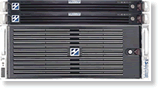 Hardware Offers
Esri offers US customers two versions of the popular Windows-based ArcGIS Data Appliance, which is now manufactured by Cutting Edge for Esri. You can choose ArcGIS Data Appliance for Windows or ArcGIS Data Appliance for Windows (Server Bundle). ArcGIS Data Appliance, based on the data collection package purchased, can provide terabytes of prerendered nationwide and worldwide data that includes street and transportation, place-name, administrative boundary, and raster imagery data. Learn more about all Esri and Cutting Edge offers.
Visit the Esri Store to find more software and extensions, upgrades, data, books, and hardware bundles.