Alabama: Advancing Public Safety with High-Tech Maps and Shared Awareness
By Carl Walter and Ken Stowell
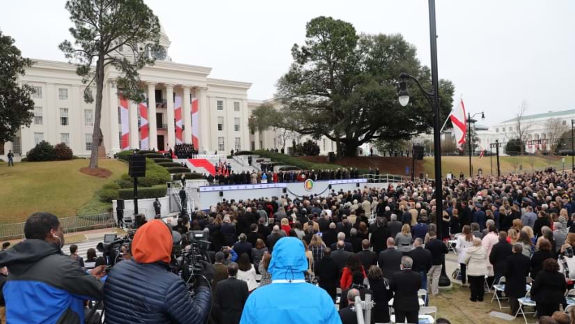
On a brisk day in January 2023, Governor Kay Ivey stood before the marble steps of the Alabama State Capitol in Montgomery, dressed in a crisp white suit to be sworn in for her second full term. As Governor Ivey gave her inaugural address, another initiation was quietly unfolding.
That same day, the Alabama Law Enforcement Agency (ALEA) deployed a new command and control system for security and tactical operations. While the governor declared her hopes for the future and acknowledged the contributions of first responders to recover from recent devastating tornadoes, a cadre of public safety personnel monitored one common operating picture powered by geographic information system (GIS) technology.
Jared Bostic, the deputy geographic information officer for the State of Alabama, oversees the use of GIS as a strategic resource for the state. His team provided support for ALEA during the inauguration ceremony and its related events.
“We were able to have that real-time awareness of where ALEA agents and troopers were [located] . . . and have visibility of downtown Montgomery, including all streets, barricades, and the parade route,” Bostic said.
When Governor Ivey visited the command center before being sworn in, ALEA’s digital twin gave her a better understanding of the law enforcement tactics being used to keep the event safe. She was impressed by the visualizations and thanked the ALEA team for its diligence.
Governor Ivey met with her security team prior to her inauguration. The screens around the room displayed the digital twin of the capitol.
ALEA relies on GIS to support workflows across all divisions, from the agency’s fusion center to its accounting department. Staff use ArcGIS Mission—software that combines situational awareness with command and control—to integrate authoritative maps, live data streams, and real-time field and command center updates. The team also deployed reality capture tools from drones and other sensors to create a realistic digital twin of the capitol. Already the innovations are helping improve decision-making and transparency during critical situations.
Staying Ahead of Potential Threats
The Alabama Fusion Center, a division of ALEA, was responsible for intelligence collection and threat assessment for the inauguration. Serving as a bridge between federal, state, local, and private agencies, the fusion center promotes collaboration to uphold public safety. On the day of the event, a joint operations center was set up, including mobile command buses from three separate agencies: ALEA, the Montgomery County Sheriff’s Office, and Montgomery Fire Rescue.
Jay Moseley, director of the Alabama Fusion Center and homeland security adviser, focused on the accurate, rapid exchange of intelligence.
“My role is information sharing back and forth,” Moseley said. “And this was a big joint operation. I knew that if I had to collect intel, I’d need to know where those assets were that could do the collection for me.” Using Mission, command center staff could track the activity and location of field agents, who used a mobile app to discreetly text updates and photos, protecting their anonymity within the crowd.
Fusion center staff initiated their threat assessment and operational planning well in advance of inauguration day, then shared the analysis and plan to ensure agency-wide preparedness. The digital twin, accurate down to floor plans and providing a direct line of sight to the governor’s podium, was used by tactical agents who monitored the governor and inauguration guests and dignitaries.
On the day of the event, two analysts tracked activity and social media to update threat assessments and inform all stakeholders.
“If things changed quickly from a steady state to a crisis state, we were prepared for that,” Moseley said.
Joint Operations and Peace of Mind
Stephen Tidwell, now the director of the ALEA Administrative Bureau, led protective services for the inauguration event. His focus was on preserving order, preventing crime, and protecting people and property at the capitol. Tidwell’s and Bostic’s teams began collaborating early in the planning process, using maps and data from previous events as a starting point.
“We put all of our site assessments together with the mapping tools,” Tidwell said. “This really allowed us that 30,000-foot view to make sure we were taking into account all potential choke points and vulnerable areas.”
Reality capture technology was used to create the digital twin of the capitol that allowed agents to explore and familiarize themselves with the area, before, during, and after the inauguration event. Image courtesy of ALEA.
ALEA teams streamlined collaboration by sharing access to the digital twin and having stakeholders indicate where they would place their assets. For example, the Alabama Department of Transportation used the twin to guide and share barricade positioning. Indoors, ALEA developed detailed emergency plan maps showing the location of tactical assets such as safe rooms, alarms, and hazardous materials.
A common refrain from those who saw the digital twin for the first time was that it lends peace of mind.
“You’re able to look at this common operating picture and see that everybody’s where they’re supposed to be,” Tidwell said. If the situation turned critical, ALEA leaders could quickly review resources and move people to priority places.
In addition to a joint operations center, Tidwell’s team had a mobile command post that was used for field staff support. Field agents visited the post to check in, pick up equipment, and receive operations plans and guidance. Conveying detailed plans through Mission meant that assignments were tightly tied to maps. The platform allowed both field and office teams to operate from the same source for real-time situational awareness.
“Having that story told in one place allowed everybody to monitor and go along with what was unfolding out in the field during the event,” Tidwell said, “whether that was fire, EMS [emergency medical services], or the SWAT team.” Individuals who were not familiar with downtown Montgomery could easily assess the situation by referring to the digital twin, using it to visualize intersections, identify buildings, and guide decisions.
Deployment Relied on a Robust GIS Foundation
Successful deployment of the command and control system on inauguration day can be attributed to years of hard work across ALEA. The seasoned GIS team has used GIS capabilities for years. Mission takes these capabilities to address the tactical operations needs of special events and packages them into one common operating picture.
As Bostic looks ahead, he envisions potential uses of Mission that are well beyond the governor’s inauguration. He is confident in the platform’s potential for future events. “It worked out tremendously well for us throughout the inauguration,” Bostic said. “And we look forward to using it in future projects.”
ALEA refined its approach for upcoming operations by using data recorded during the governor’s inauguration event. Tidwell led the analysis, using Mission as the system of record to review the sequence and details of every decision and action made that day.
“We used GIS as a tool to prepare our after-action report,” Tidwell said. His team uncovered insights such as where more resources were needed and where communication could be improved. “It’s the little things we learned along the way that guide our discussions.” These lessons will direct future strategies and strengthen coordination among Alabama’s first responders.
I believe it is imperative to invest wisely in technology that maximizes our resources and enhances our ability to promote public safety. After careful consideration, the decision was made to use a platform that met the agency’s needs, while simultaneously allowing us to grow and improve efficiency. We needed a GIS that could be configured to support just about any operational requirement, whether it be tracking investigative assets, troopers on our roadways, or specialized tactical teams such as the one we used at the Alabama State Capitol during inauguration day 2023. ArcGIS Mission was our solution of choice, and it is another excellent example of how we operationalize information through GIS.
Hal Taylor
Secretary of the Alabama Law Enforcement Agency
Share this article:
Alabamaeventslaw enforcementpublic safetysecurity
Carl Walter
Carl Walter, Esri’s Director of Homeland Security Solutions, joined Esri in 2010, after 20 years of increasing responsibility in law enforcement and intelligence operations. Shortly after 9/11, Mr. Walter was appointed Director of the Boston Regional Intelligence Center, a US Department of Homeland Security designated intelligence fusion center. He embraced the new paradigm of intelligence sharing and established a decentralized security node in the Boston metropolitan AoR responsible for meeting regional intelligence needs, while providing real-time information to help understand the national landscape of terrorist threats and criminal activity. On special assignment, Mr. Walter represented the Boston Police as the planning section chief for the Democratic National Convention in Boston in 2004. He also served as the Director, Bureau of Intelligence and Analysis for the Boston Police Department. Currently, he is responsible for directing Esri’s outreach strategies as they relate to the use of analytical solutions within the homeland and national security markets globally. Mr. Walter holds an M.S. in Criminal Justice (Concentration: Management) from the University of North Carolina at Charlotte, and a B.S. in Criminal Justice (Concentration: Law Enforcement) from East Carolina University in Greenville, North Carolina.
Ken Stowell
Ken Stowell, Esri's account executive for Field Operations, joined the company in 2022, after 20 years of increasing responsibility in defense and law enforcement intelligence operations. He is a veteran of the US Army and worked in multiple federal agencies. His last role was as a supervisory intelligence analyst in the Federal Bureau of Investigation. Currently, he assists public safety entities leverage the power of ArcGIS to overcome field mobility challenges. Stowell holds an MBA (concentration: management) from Rockhurst University in Kansas City, Missouri, and a BSBA from the University of Maryland GC.