
February 18, 2025 |
David Gadsden | Conservation
Emilie Brignall can now see everything Wessex Water has done for nature in one place—hundreds of sites, dozens of active projects, thirty-year projections, assembled into a single spatial picture. “We can very quickly measure how many units of biodiversity we have already created and how many units we will have created in a decades’ time,” she said. “That number means something to our regulators and to our customers, who want to see biodiversity supported.”
That picture exists because of a law, a dataset, and a tool that aligned within the past two years.
Ordnance Survey (OS), Great Britain’s national mapping service, provides the ecological data foundation that Linckia—an environmental technology company specializing in biodiversity net gain—turns into practical tools. Tools that Wessex Water, serving 2.9 million customers across the southwest of England, puts to work on the ground.
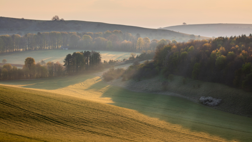
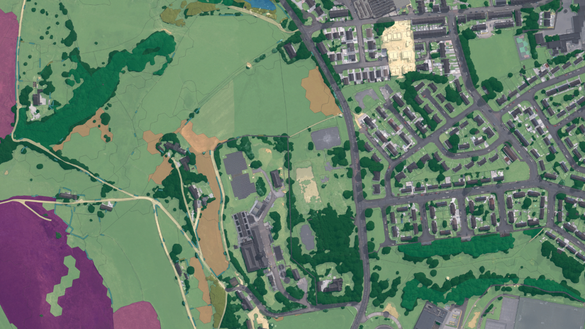
England is one of the most nature-depleted landscapes in the developed world. Centuries of Roman land management, Norman deforestation, agricultural intensification, and urban growth have stripped away habitat layer by layer. The countryside looks green. But it functions poorly as a connected, living system. The UK has recognized the problem. For the first time, it now has the data to act on it.
Biodiversity Net Gain—the law that requires most new development to leave nature measurably better off—is the policy mechanism. Behind it, a new generation of mapping data and field tools is making restoration possible—parcel by parcel, site by site, across the length of England.
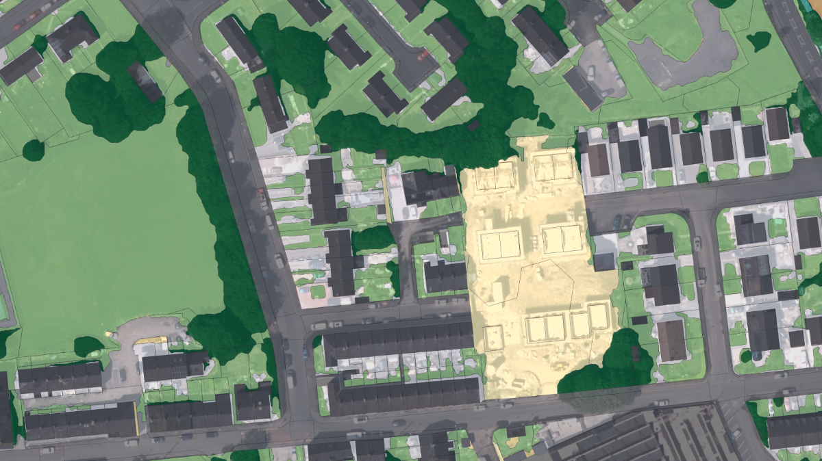
In February 2024, Biodiversity Net Gain—BNG—became mandatory for most new development in England. The principle is simple and radical: any development that affects nature must leave it at least 10 percent better off. Developers and landowners are now required to measure ecological value before breaking ground and demonstrate a measurable gain when the project is done.
Three organizations are showing how it works with geographic information system (GIS) technology.
Ordnance Survey (OS) has been mapping Britain for over two centuries and pioneered the digital transformation of that work. Surveyors keep the national map updated with 30,000 daily changes to the digital master map of Britain using precision technology and field apps, piloted aircraft and unpiloted aerial vehicles (UAVs) that capture high-resolution imagery, and automated workflows that detect and deliver only what has changed. BNG demanded something more: what the land was worth to nature.
When BNG became law, OS recognized an opportunity to extend the map to meet the new requirements. Partners across the ecology sector were looking for countrywide data, and it became clear that OS was uniquely placed to fill the need. Dr. Jack Parkin, product manager for OS’s Built and Natural Environment portfolio, describes what they built as a foundation for decisions. “It’s like getting the chessboard out and putting all the pieces on, ready for the partners to play,” he said. “Whereas before, they had to build the board themselves.”
The OS Enhanced Land Cover Beta dataset combines aerial imagery, topographic polygons, and third-party data from organizations such as Natural England into a single view of land from a nature perspective. What OS designed is a base layer partners could build upon: climate risk calculation, agricultural assessment, and biodiversity measurement. The habitat classifications within the data are defined by UKHab, an independent habitat classification system with detailed taxonomy of habitat types now written into BNG legislation as the field standard. The OS Enhanced Land Cover dataset incorporates this ecological classification alongside one of the most precise and up-to-date basemaps in the world. OS is extending its contract with UKHab, gathering user feedback, and refining the product before the dataset’s full release. For an authority whose reputation rests on data you can trust, that carefulness is the point.
The OS Enhanced Land Cover dataset provides a cartographic bedrock for the BNG data ecosystem. Translating it into something field ready became Linckia’s work.
Luke Chittock, cofounder of Linckia, spent two decades in GIS before BNG created the opportunity he’d been positioned to see. “Net gain is about positive nature outcomes,” he said, “but it’s a data story.” The legislation existed. Making it work in practice—connecting nature data to tools that professionals could act on—was the challenge.
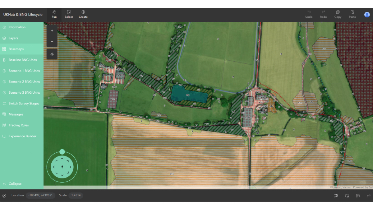
Linckia designed Habitat Fabric to be technology agnostic but built it specifically on Sweet for ArcGIS, Esri UK’s data collection platform designed for accurate field data capture with built-in quality checks. Sweet enforces valid data entry at the point of observation. Linckia extended it for habitat survey and biodiversity measurement, building BNG compliance directly into a field app for ecologists.
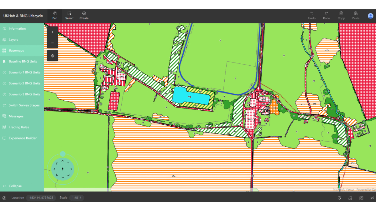
Turning the OS Enhanced Land Cover data into field-ready form required roughly 100 steps in Esri’s Model Builder, flattening thousands of overlapping polygons from OS Enhanced Land Cover into a single habitat layer. Linckia enriched the output with third-party data, tested across a year of live projects. The result is Habitat Fabric.
An ecologist arrives at a site with the landscape already classified and the habitats already mapped. The ecologist’s job is to verification, refinement, and judgment. They record habitat type, condition, and species indicators in the app. The BNG metric calculates automatically—no spreadsheet, no export, no manual reconciliation. Surveying, classification, calculation, scenario planning, and reporting happen in one workflow. Survey times are typically cut by 60 to 70 percent.
On-screen, each habitat type appears in coded color. Baseline conditions sit alongside post development scenarios, monitoring data and project management layers—and every edit updates the picture in real time.
This efficiency matters because ecologists are scarce. By law, BNG surveys must be carried out by qualified professionals, and there are currently not enough of them to meet the demand the legislation created. But salaries are finally rising to reflect the skills it made essential. Every hour saved through better tools lets them apply judgment, read nuance, and make calls that algorithms cannot. “We want to encourage ecologists to apply their professional judgment and not have their role superseded by AI,” Chittock said. The platform is designed to extend expert capability, with data quality, transparency, and decision traceability built into every step.
For the first time, Wessex Water can see everything it has done for nature in one place. Hundreds of sites, dozens of active projects, and 30-year projections are assembled into a single spatial picture that previously existed only in fragments across spreadsheets, project maps, and manual records.
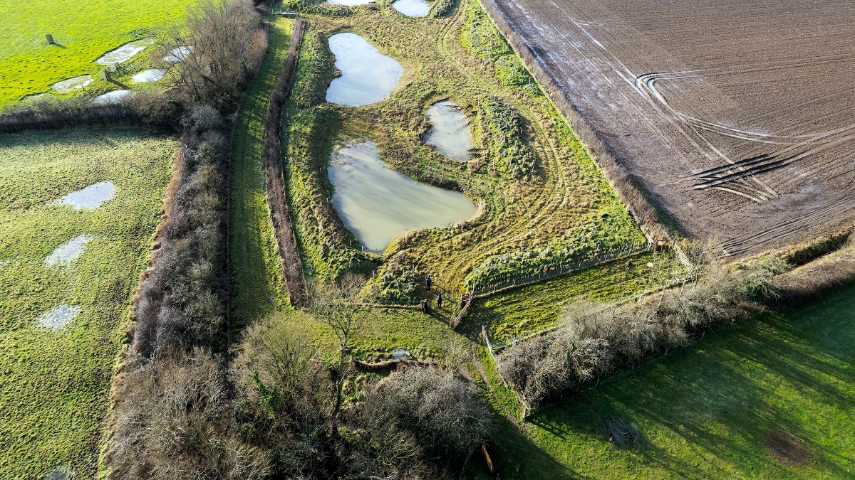
Emilie Brignall leads conservation and recreation programs for Wessex Water, managing a team of ecologists to increase biodiversity across roughly 3,000 hectares of company-owned land in Wiltshire, Dorset, and Somerset. The utility’s five-year mandate, agreed upon with regulators, was to improve the biodiversity of the landholding. That means woodland creation, priority habitat restoration, wetland construction, habitat management for birds, and early-stage investigation of peatland restoration. Linckia underpins all of it—estimating impact, tracking progress, and reporting outcomes.
Wessex Water already had strong GIS capability. Spatial data is core to how a water utility manages its assets—pipe networks, treatment works, catchment areas, source protection zones, and so on. Linckia extended that infrastructure data into ecological measurement, bringing the BNG metric out of a stand alone spreadsheet and into the GIS environment where the rest of the work lives.
Now sites are tagged to projects and the data rolls up to reports. A woodland creation program spanning dozens of parcels becomes a single legible account of habitat established, its condition, and biodiversity value generated. And for programs measured in decades, the forward projection capability changes what’s possible. Plant saplings today, and the tool calculates what that woodland will be worth in biodiversity units in 30 years—before a single tree qualifies as measurable habitat.
The team operates across four local nature recovery strategies—regional frameworks that set conservation priorities for their areas. Those strategies shape site-level decisions: plant trees or clear scrub, manage grassland or water-dependent species, connect a local site to a wider ecological corridor. GIS is the language through which regional priorities and on-the-ground decisions are held together.
For a water utility, healthy land and reliable water are the same investment. Restored wetlands slow runoff. Woodland filters what reaches the chalk aquifers that supply the taps. Managed grasslands reduce pollution caused by farming. When extreme weather puts pressure on drainage and catchments—as it increasingly does—the ecological condition of the land is the first line of response. Nature-based solutions and biodiversity net gain are two names for the same logic.
Ordnance Survey provides the data. Linckia refines it and builds the tools. Large landholders like Wessex Water put both to work across thousands of hectares of living land.
Water utilities, farmers, rural estates, and local authorities across England are now working to quantify and improve the biodiversity value of their holdings. BNG gives organizations a measurable framework to demonstrate what good stewardship of the land actually looks like—translating ecological commitment into units that regulators, investors, and the public can understand and hold them to.
For many, BNG has opened an entirely new land economy, with habitat restoration generating long-term revenue alongside ecological value. The BNG credits market is estimated to be worth as much as £274 million annually, and the framework is gaining traction globally as countries align around shared commitments to halt biodiversity loss. A year on from mandatory biodiversity net gain, the picture is one of genuine momentum and a growing recognition that the tools and data infrastructure to make restoration measurable now exist.
Centuries of intensive land management stripped England of native habitat. BNG makes reversal a legal requirement—through measurement, mandate, and market mechanisms. Landholders are showing what the mandate looks like when it extends beyond planning into everyday land management.
The tools exist. The data exists. Restoration is underway, one parcel at a time.
Learn more about how GIS protects biodiversity and puts nature on a path to recovery.