


August 16, 2022 |
Sydney Rich | Infrastructure
March 30, 2023
Maryland’s most densely populated and wealthiest county updates maps and models of planned development—creating a planning digital twin—to shape housing and sustainability goals. The result: This dynamic digital twin gives developers an accurate picture of potential opportunities. It also helps the public understand what their community—down to a single block—will look like in the future.
Many of Montgomery County’s 1.06 million residents live in Bethesda and Silver Spring, urban enclaves just outside the nation’s capital. Like urban areas across the US, planners there contend with balancing affordable housing and an interest in preserving forests and farms.
Montgomery County officials have pioneered new ways to manage these issues for decades. To address affordable housing in 1974, the county implemented the nation’s first successful moderately priced dwelling unit program. In 1980, the county established the Agricultural Reserve by preserving 93,000 acres—almost a third of its land resources. A few years later, density placement was transformed by the Optional Method of Development, which allowed higher densities in urban areas in exchange for added public amenities or increased land preservation in rural areas.
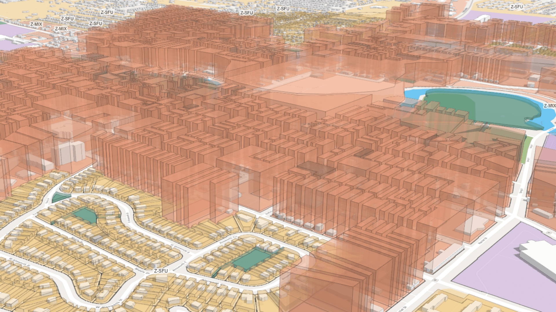
To keep pace with changing demographics and housing demand, Montgomery Planning staff have embraced geographic information system (GIS) technology. The county uses GIS to increase transparency, keeping developers and the public informed about projects while speeding regulatory processes. They are digitizing 2D plans, integrating them with 3D modeling software, and sharing them online. The dynamic digital twin that keeps pace with plans gives developers an accurate picture of potential areas of opportunity.
Montgomery County’s Thrive 2050 plan prioritizes dense, sustainable housing. It concentrates growth in downtown areas, emphasizes transit-oriented development, and insists on racial equity and climate resilience. Passed with a unanimous planning board vote, the award-winning plan has officials optimistic that it will address housing needs far into the future.
“We know we need to satisfy more residential development to keep housing affordable,” said Chris McGovern, manager of the Information Systems/Geographic Inventory System at Montgomery Parks and Planning. “By focusing growth along certain transit corridors near metro stations, we’re giving developers an incentive to build a missing middle housing solution where duplexes, triplexes, and infill development can grow.”
The department has used digital tools to inform the public for years. The Development Activity Information Center (DAIC) indexes project descriptions, maps, drawings, and other information. The MCATLAS map viewer displays related data—county and election boundaries, priority funding areas, and opportunity zones. An interactive Development Activity map outlines developments by type and tracks progress.
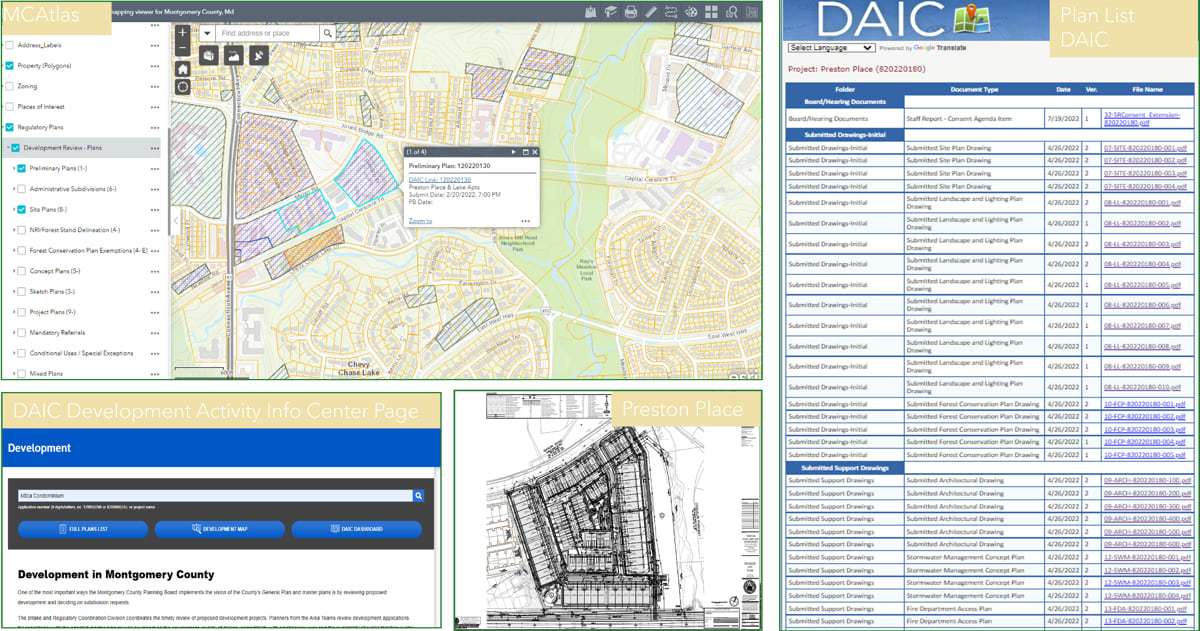
Even with this robust set of resources, the county’s city planners and GIS specialists knew they could offer a more intuitive view of planned growth. “The DAIC is where we convey our regulatory information to the public so that they have visibility on the process and take part in our meetings,” McGovern said. “But we wanted to 3D render those projects, so they’d be able to understand what we’re talking about without having to look at two-dimensional architectural drawings.”
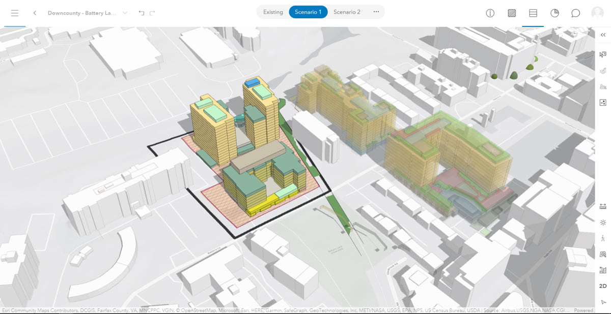
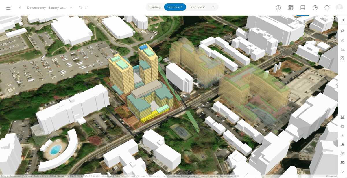
This, McGovern said, is where smart city planning software came in to create a countywide planning digital twin. Specialists combine 2D drawings and documents to generate a 3D model in ArcGIS Urban. Layers such as building footprints and property lines add context to the model to give anyone a quick visual of what is proposed. Architects, planners, and developers can access ArcGIS Urban to see the project’s spatial aspects—something that once required looking through dozens of documents.
“I used to struggle to try to publish 3D things,” said Jay Mukherjee, the planning department’s principal GIS specialist. “The ability to create these amazing models that you can fly around and see in relation and in context to the surrounding built and natural environment is incredible.”
The planning digital twin also makes it easier for planners and city officials to check the impact of land-use changes.
“The models distill the required elements of the proposal—green space, open space, pedestrian and vehicular circulation, parking, number of units, densities, and building height—and display the essential elements approved by the planning board,” said Mary Beth O’Quinn, a Montgomery County architect and urban planner.
The ability to quickly check that proposals meet all statutes, zoning, and building regulations, O’Quinn said, transforms her work.
By pairing Thrive 2050 goals with powerful digital twin technology, Montgomery County has modeled additional ambitious projects for future growth.
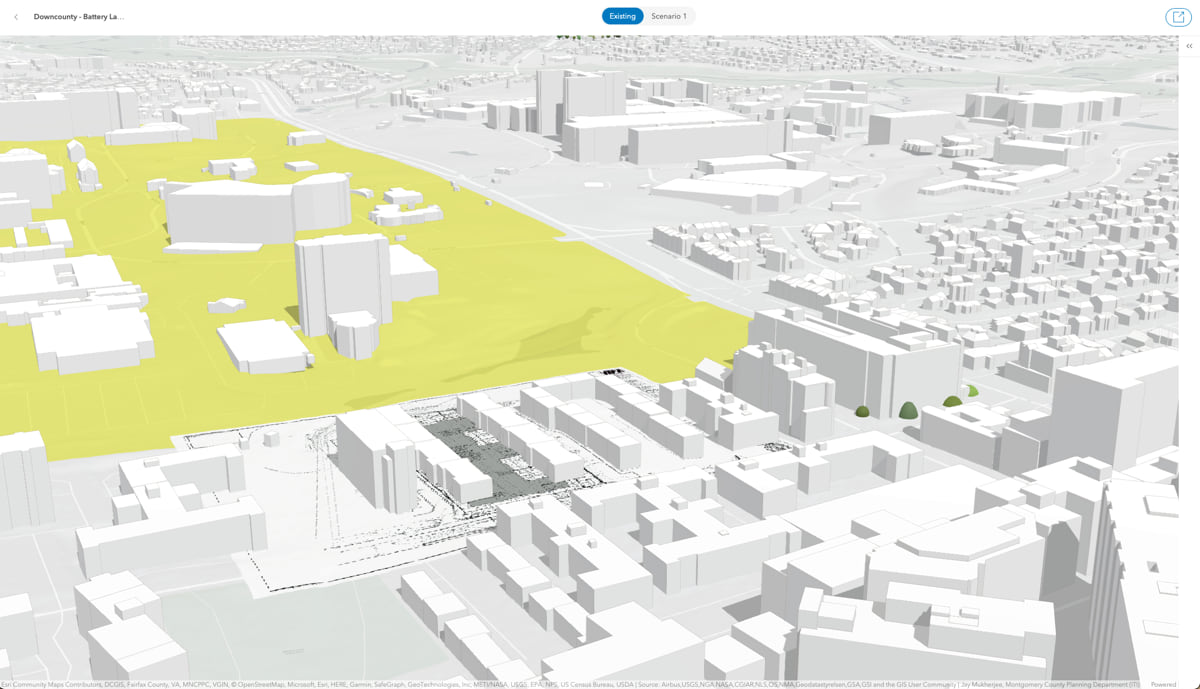
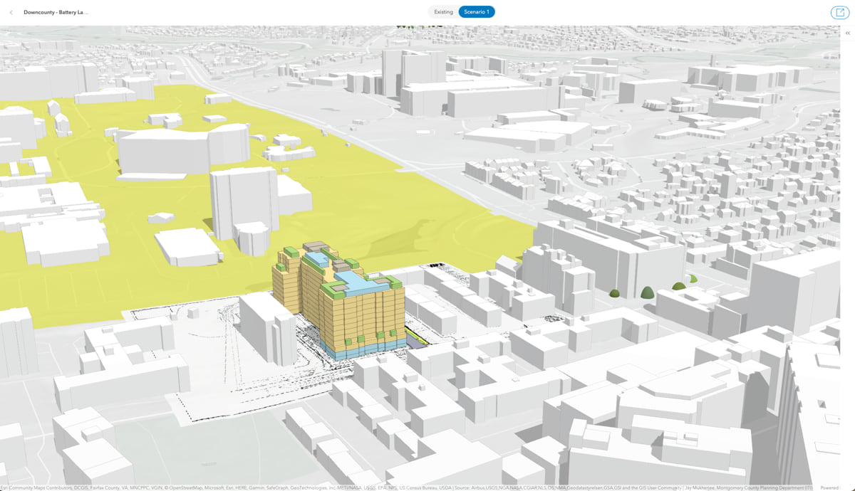
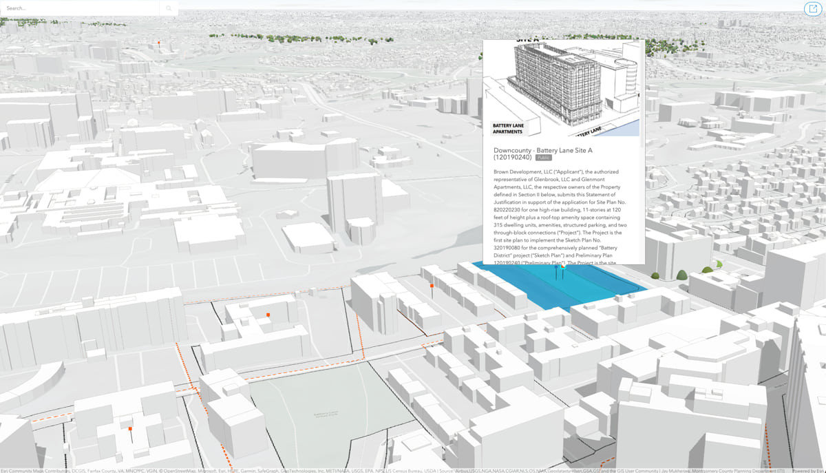
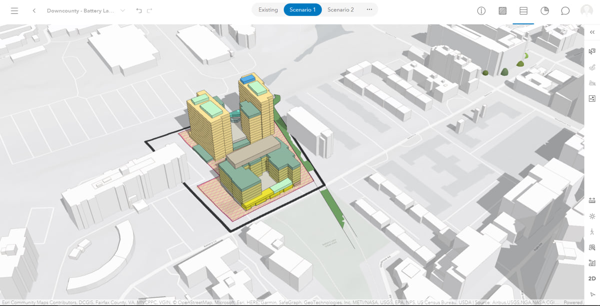
Mukherjee and O’Quinn used ArcGIS Urban to build a model of a proposed high-density housing development on Battery Lane, just south of the National Institutes of Health’s (NIH) 300-acre campus in Bethesda. The new 10-story luxury apartment building will offer far more housing than the postwar three-story apartment buildings it will replace. O’Quinn and her colleagues posit that some of NIH’s 18,000 employees will want to live there.
Development that creates more walkable communities is one of the county’s priorities. Restaurants, a park, many bus and metro stops, and small businesses are within a 10-minute walk from the new project. On Sundays, residents can walk less than a mile to the Bethesda Central Farm Market for goods and fresh produce—including those grown on the county’s agricultural reserve.
As projects are added to ArcGIS Urban, they will soon be shared on the planning department’s ArcGIS Hub site. The new site will sort projects based on their timeline: under review, approved, under construction, and completed.
Even though a new building takes years to complete, the benefits of the models on the county’s digital twin are immediate. “It’s our responsibility,” McGovern said, “to convey the work we’re doing in a digestible way to the engineering and architectural communities and the residents who are getting these things built next to them.”
Learn more about how planners use GIS for urban and community planning initiatives and economic development.
Montgomery County now includes a link to the urban model from the Development Activity Information (DAIC) site. The model makes use of the “shadow buildings” technique to create visually impactful and informative plans that represent planned development in the county. View this update in the video below.