
October 9, 2019 | Multiple Authors |
August 17, 2021
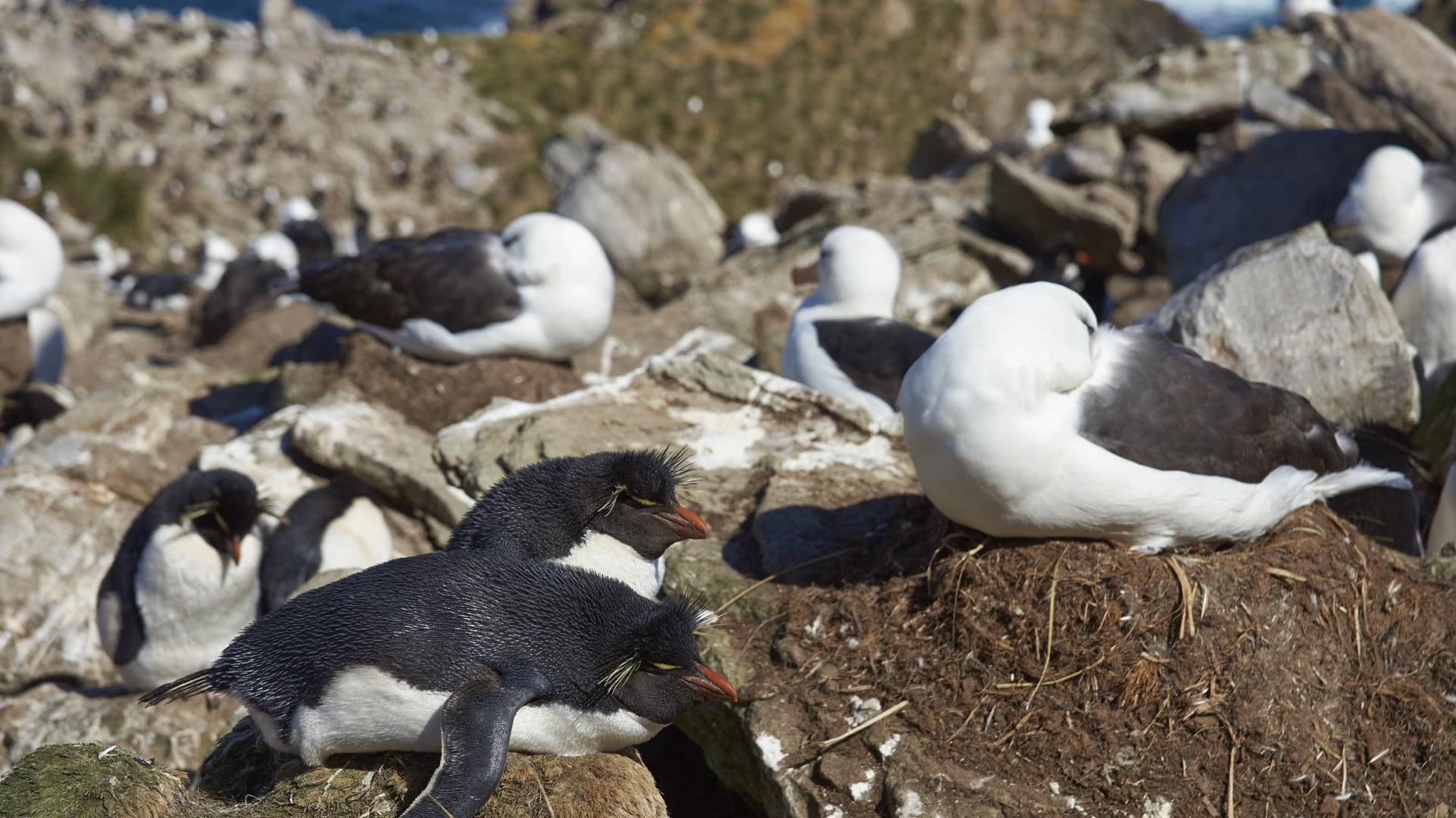
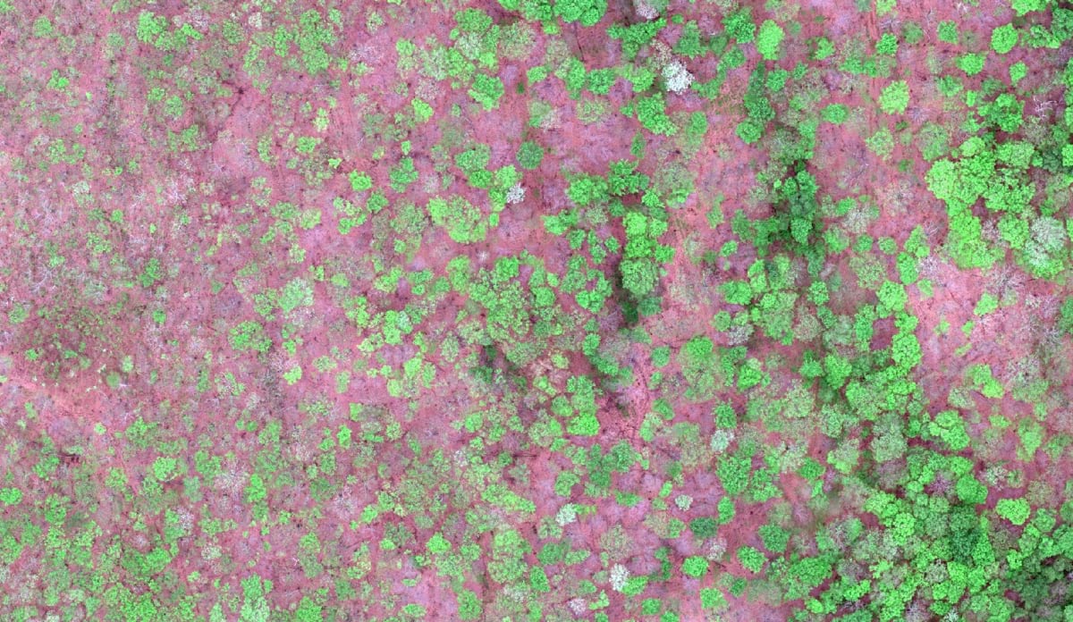
The Falkland Islands contain some of the world’s largest seabird breeding grounds. Here, thousands of black-browed albatrosses and southern rockhopper penguins coexist with around 230 other bird species. For scientists committed to counting the bird population—essential for measuring the health of the populations and the effects of environmental changes—manual counts can be tedious, time-consuming, and prone to errors.
Wildlife biologists recently employed a novel application of remote sensing, a broad term that refers to gathering data on an area or object without physically interacting with it. Instead of inspecting the area on foot, they sent drones flying overhead to capture around 10,000 images that were organized within a geographic information system (GIS).
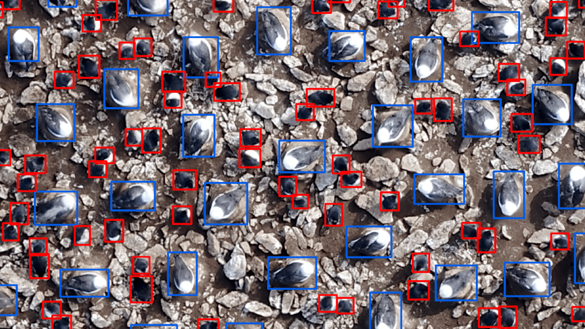
Madeline Hayes, a remote sensing analyst at Duke University’s Marine Lab, used these images to teach a deep learning program to distinguish an albatross from a penguin. Armed with the knowledge, artificial intelligence (AI) was able to perform a quick and accurate count. The newly classified data was imported into the GIS to generate a color-coded map of species distribution over the study region.

Hayes studied remote sensing at the University of Vermont’s Spatial Analysis Lab, where Jarlath O’Neil-Dunne, the program’s director, trains students in using remote sensing to tackle environmental problems.
“One of the reasons I love our lab is we’re in UVM’s School of Natural Resources, not the Geospatial Studies program,” he said. “Geospatial technology is just a tool we use to solve environmental problems.”
He points to Hayes’ work as an example of how important domain knowledge is in relation to technological know-how. “She came to us with no drone experience, but what really made her successful is she wasn’t enamored with the technology,” he said. “We need technology experts, but we also really need folks who can couple subject matter expertise with the technology. How many drone experts understand how to apply drones to the problem of mapping penguins in the Falklands?”
Drones and GIS share a natural symbiosis. For millennia, maps have provided a bird’s-eye-view perspective that helps people contextualize large areas. Drone imagery makes this bird’s-eye-view literal, while GIS syncs the images to a map where they can be analyzed along with other data. By locking the images to precise physical locations, GIS allows people to examine the same areas over time.
Until recently, remote sensing required access to expensive technologies, such as satellites or piloted aircraft using lidar to create 3D images. Drones, which have become both less expensive and more popular in recent years, can now facilitate many of the same functions. “Drones have really democratized remote sensing,” O’Neil-Dunne said.
The danger, as with so many accessible technologies, is that this ease can obscure the need for a strong foundation. It’s not enough to simply fly a drone and let the technology work its magic. O’Neil-Dunne emphasizes a strong grounding in the fundamentals of remote sensing with his students. But what are those fundamentals?
At the most basic level, remote sensing is the same, no matter what technology is used. Some kind of electromagnetic radiation, such as sunlight or a laser collecting lidar data, illuminates a target. This energy bounces off the target, to be recorded by a sensor and sent to a processor to build an image. From this output, objects can be detected, counted, quantified, and a number of relevant conclusions can be drawn.
Within these simple steps lies an enormous amount of variation, requiring the operator to know something about methodologies and the benefits and limitations of different tools and approaches. Some terrain, such as wetlands, requires very careful application and a diverse knowledge base for remote sensing to yield decent results. Operator decisions encompass everything from sensor calibration to resolution rates to segmentation algorithms.

O’Neil-Dunne’s idea of remote sensing fundamentals includes a keen understanding of the most recent findings on human cognition. The goal is not only to understand how machines deal with data, but also how people process information derived from data. The ability to synthesize information and apply it to domain expertise produces what O’Neil-Dunne calls optimal remote sensing tradecraft.
“Remote sensing has always been both an art and a science,” he said. “My concern is that in today’s world we’ve focused too much on the science side—specifically, the data science side. We’ve run the risk in the last decade of creating a new batch of professionals that are very proficient at processing large amounts of data using fancy algorithms but may lack the domain expertise and qualitative skills necessary to solve the pressing problems of the future.”
For O’Neil-Dunne, an effective remote sensing project is about telling a compelling story with visuals. Just as an author can bring a lifetime of diverse experiences to bear when crafting a novel, a knowledge set that includes—but isn’t limited to—technical considerations can strengthen a story told through remote sensing.
O’Neill-Dunne returned to the topic of Hayes’ Falklands project. “She’s talked about the challenges she had in developing a deep learning training set of 10,000 penguin reference points, all so she could count hundreds of thousands of birds,” he said. “You can imagine all the different skills that she needed, that she developed and accumulated along the way, to pull that off.”
Learn about the latest advancements to host, stream and analyze imagery in the cloud.

October 9, 2019 | Multiple Authors |
January 27, 2020 |
May 6, 2021 |