

July 19, 2022 | Multiple Authors |
May 16, 2023
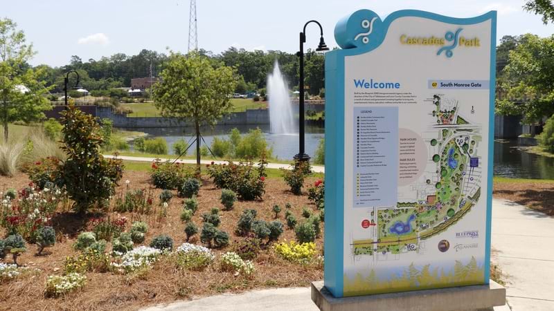
At the heart of Cascades Park in Tallahassee, Florida sits the Prime Meridian Marker. Originally placed in 1824, the marker serves as the starting point for all Florida land surveys, making it a symbol for new beginnings and a fitting cornerstone of a recently redeveloped recreational haven.
The park is a 24-acre expanse named for the cascading waterfall on its grounds. It features trails, playgrounds, and an amphitheater for outdoor concerts. It also serves as a stormwater retention basin to provide flood relief during storms. Once home to a gas plant and landfill, the area underwent a series of cleanup activities, including the removal of polluted soil and construction of a clay liner to improve groundwater conditions.
The US Environmental Protection Agency (EPA) has been making this type of redevelopment easier by providing maps that share reuse success stories and identify sites that can support future reuse. Since the Superfund program was enacted by Congress in 1980, more than 1,000 sites like Cascade Park Gasification Plant have been cleaned up and repurposed. Remediated lands have found new life as shopping centers, business parks, residential subdivisions, farmland, parks, and recreational facilities. EPA launched the Superfund Redevelopment Program (SRP) in 1999 to create and share tools and resources to support safe and equitable reuse. In this way, SRP is supporting communities, property owners, and other stakeholders to transform blighted areas into valuable assets.
Alexis Rourk Reyes, the manager of the SRP program, has a background in land-use planning and is continuing the program’s longstanding practice of using geographic information system (GIS) technology to show what’s possible.
The Superfund Redevelopment Mapper highlights details about all Superfund site locations, providing key information that will lead to their renewal.
“Maps give everybody the opportunity to view all the respective assets in a community or area of risk,” Rourk Reyes said. “It helps document what the community’s experiences have been, what their interests are, and what their vision may be. Maps are a fundamental piece of what we do.”
Once EPA determines that a site is safe for reuse, the next challenge is making that land an asset once again.
Anyone can search the Superfund Redevelopment Mapper for sites based on factors such as proximity to highways, solar potential, or access to essential services. The tool also provides demographics of the people and communities nearby.
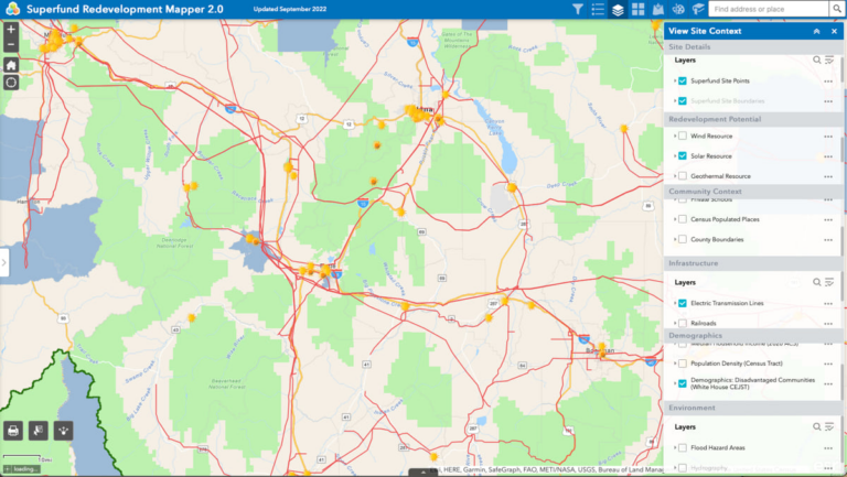
Interested parties can quickly identify areas where their project would be successful. A solar farm developer, for instance, can narrow their scope to flat, rural locations with high solar potential and access to high-voltage power lines. Local governments could identify communities in need of basic services, such as those in food deserts, to craft a redevelopment pitch to grocery store developers.
“One of the things I’ve focused on since I started in this role is meeting unmet community needs, whether it be education, housing, jobs, or recreation,” Rourk Reyes said.
A key consideration for developers is how quickly they can move from investment to construction to occupancy. The reuse of Superfund sites can be done safely because EPA has a deep understanding of the land and its opportunities and limitations. Because many Superfund sites are located near underserved populations, the reuse of sites can help communities tackle deep-rooted challenges, such as equitable development and clean energy production.
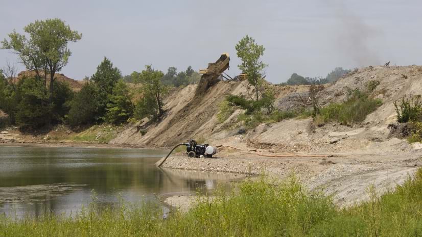
On the Conroe Creosoting Company site in southeast Texas, for example, a wood-treating facility marred the landscape and contaminated soil and groundwater for half a century. After years of cleanup, a developer acquired the property and made improvements to prepare the area for use as an industrial park. In 2021, a $51 million Home Depot distribution center began operating there, bringing job opportunities and tax revenue to the community. With the increase in traffic to the area, the city of Conroe was able to prioritize funding for a long-anticipated road extension project. EPA successfully partnered with the Texas Commission on Environmental Quality to collaborate with site purchasers, local government, and stakeholders to support the reuse project and bring added benefits to the community.
“EPA doesn’t own any of the sites, and we don’t decide what happens on the site, and I think that’s a good thing,” Rourk Reyes said. “The process of reuse and redevelopment is grounded in local needs and local opportunities.”
All stakeholders, from potential developers to community planners, can see what land might fit for a return to manufacturing, clean energy development, or repurposing for parks.
Local EPA site teams answer questions about safety, liability, and ownership. Local governments determine the zoning and how land can be used. And then individual actors create the opportunity.
Partnerships play an important role in finding creative, beneficial uses for Superfund sites. As program manager, Rourk Reyes appreciates how alignment with partners such as Rails-to-Trails Conservancy, the US Soccer Foundation, and the Trust for Public Land, forges repeatable patterns and mutually beneficial outcomes on remediated land across the nation.
“We even have a partnership with the Academy of Model Aeronautics to turn some of the more remote sites into flying fields,” Rourk Reyes said, referring to a nonprofit community of model plane enthusiasts. “It works out for the owner of the site because the group mows and maintains the site and keeps an eye on the land. They also have training programs for students, providing engineering and aeronautics experiences.”
Rourk Reyes hopes the SRP maps will help others see the advantages of redeveloping and reinvesting in rural locations.
“Maps are such a natural way to manage complex information and tell the series of stories about revitalization,” she said.
Learn more about how GIS helps guide urban and community planning and revitalization.


July 19, 2022 | Multiple Authors |
April 6, 2020 |

May 24, 2022 |