ArcGIS GeoBIM delivers a connected data environment that seamlessly links architecture, engineering, and construction (AEC) information in Autodesk Construction Cloud with geospatial data and services in ArcGIS. Easily build and share apps, field maps, and issue dashboards to simplify communication, mitigate risk, and keep teams coordinated with the latest information at their fingertips.
The June 2025 release of ArcGIS GeoBIM streamlines GIS and BIM integration with simplified 3D models, expanded flexibility for building custom web apps, and support for more file formats.

Release Highlights
Discover the latest capabilities available in ArcGIS GeoBIM and try them out for yourself. Have questions or product feedback for our product team? Share them by making a post in Esri Community.
Simplified 3D models streamline the integration of GIS and BIM
The new Add Document Models tool in ArcGIS GeoBIM makes working with frequent changes to large infrastructure and building models more efficient. It creates simplified, performant 3D models from Revit and Industry Foundation Classes (IFC) documents with links to the sources in Autodesk Construction Cloud.

Currently available in beta, this tool reduces BIM file sizes by up to 95%, automates georeferencing, and generates ready-to-use 3D web scenes.
It’s optimized for fast updates—making it ideal for teams that need to visualize spatially accurate BIM content without the overhead of full model complexity.

Simplified 3D models are optimized for performance and collaboration. They maintain direct links to the original Revit or IFC documents in Autodesk, ensuring access to the latest full model detail when needed. This makes them well-suited for use in construction monitoring, stakeholder engagement, and mobile workflows in the field.
By simplifying updates and ensuring spatial precision, teams can save time, access critical design data faster, and improve decision-making with responsive, geolocated BIM content that’s easy to keep up-to-date.
Read this article to learn more about the benefits of using simplified 3D models and building layers across ArcGIS.
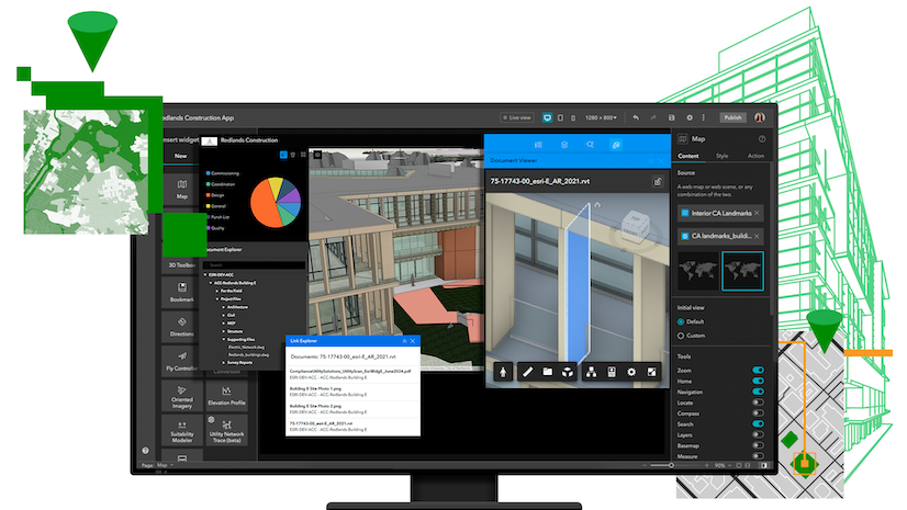
New ArcGIS Experience Builder widgets to build custom web apps
Three new widgets in ArcGIS Experience Builder give teams more ways to build more powerful, customized web apps that connect GIS and AEC data. Designed to enhance integration with Autodesk Construction Cloud, these widgets extend the ArcGIS GeoBIM experience for improving collaboration and project insights:
- Document Viewer: View and interact with linked 3D models and 2D documents.
- Link Explorer: Explore all project data linked to features in web maps or scenes.
- Document Explorer: Easily explore a folder tree of all project documents and data.

With new ways to connect GIS and AEC data in customized ArcGIS Experience Builder web apps, teams can improve information sharing, project collaboration, and decision-making.
Whether you’re a user of ArcGIS GeoBIM looking to customize project apps—or a user of ArcGIS Experience Builder looking to work with building information modeling (BIM) data—these new widgets offer expanded possibilities for building web apps your way.
Read this article to learn more about the widgets, what you can build, and how to get started.

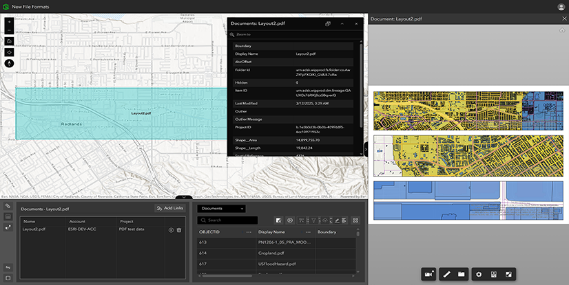
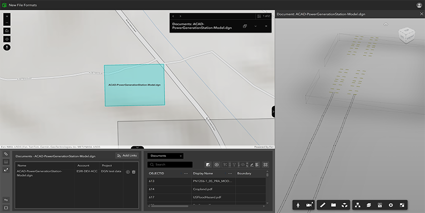
Support for JPG, PDF, and DGN files
By integrating commonly used formats, including PDFs and DGNs often used in transportation infrastructure workflows, ArcGIS GeoBIM transforms static files into strategic, collaborative assets. With a unified platform for accessing CAD drawings, field images, and engineering documents, project teams can reduce delays, improve coordination, and focus more time on execution instead of file management.
-
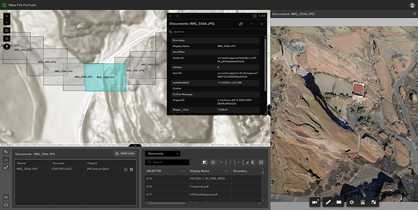
ArcGIS GeoBIM now supports bringing JPG project photos, PDF documents, and DGN files into geospatial context.
Discover more
ArcGIS GeoBIM supports project to revitalize Wrexham stadium
Ramboll piloted GIS and BIM integration on the historic Wrexham A.F.C. stadium—a project with the backing of Hollywood stars Ryan Reynolds and Rob McElhenney. The team brought together siloed workflows between design and environmental teams, allowing them to better collaborate, visualize designs in geographic context, and track issues before construction began.

Esri and Autodesk customers integrating GIS and BIM
Watch AEC firms like Ramboll and infrastructure owners share the benefits of using GIS and BIM together to break down silos and make better decisions in geospatial context. Hear from leaders at Arup, Arcadis, HDR, Parsons, and more.
GIS and BIM/CAD at the 2025 Esri User Conference
The world’s largest geographic information system (GIS) conference is taking place July 14-18 in San Diego, California. This year’s theme is: GIS—Integrating Everything, Everywhere. If you’re attending in-person, discover the ways BIM and CAD integrate with GIS workflows. Find sessions to add to your schedule and where to connect with experts in the Esri Showcase.

Access resources, documentation, and more
Learn more about the integration capabilities of ArcGIS GeoBIM with resources like tutorials, recommended training classes, videos, and articles on GIS and BIM workflows. You can also find links to connect with other users in Esri Community and share product ideas.
Get started
With a Contributor user type or above, you can access ArcGIS GeoBIM as an included app in ArcGIS Online or ArcGIS Enterprise 11.4 and higher. To create ArcGIS GeoBIM projects, you’ll need a Creator user type or above along with Autodesk licensing.
Don’t have an ArcGIS user type? Explore pricing or start a 21-day trial of ArcGIS Online today.
New to Esri and ArcGIS? Get started with ArcGIS for BIM and CAD.


Article Discussion: