No two projects are exactly the same—and the apps that support them shouldn’t be either. As architecture, engineering, and construction (AEC) projects grow in complexity, teams need tools that adapt to their unique needs and workflows.
The June 2025 update of ArcGIS Online introduces a new way to connect architecture, engineering, and construction (AEC) data—drag-and-drop widgets in ArcGIS Experience Builder that integrate with Autodesk Construction Cloud.
These widgets extend the integration capabilities of ArcGIS GeoBIM, enabling teams to build powerful, highly customized apps that enhance collaboration, streamline data exploration, and support timely decision-making.
Whether you’re a user of ArcGIS Experience Builder looking to work with building information modeling (BIM) data—or a user of ArcGIS GeoBIM looking to customize project apps—these new tools offer even more possibilities for building web apps your way.
Extending ArcGIS GeoBIM for customization
ArcGIS GeoBIM was designed to serve as a connected data environment, linking ArcGIS to AEC information in Autodesk Construction Cloud. By integrating these enterprise platforms, teams can improve collaboration from initial design through operations—empowering better decisions and outcomes.
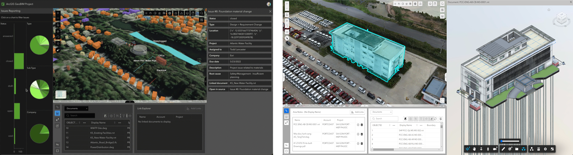
Until now, ArcGIS GeoBIM has followed a configuration-first approach. Using built-in settings, teams could create project web apps and dashboards from templates, link to Autodesk Construction Cloud data, and configure immersive, map-based views of models, documents, and issues.
This approach is ideal for locating AEC project information on a map, managing issues between the field, and delivering consistent experiences across teams.
Now, with the new widgets in ArcGIS Experience Builder, users can go beyond ArcGIS GeoBIM app configuration and fully customize apps to meet unique project, client, or operational needs. This expanded flexibility empowers teams to:
- Tailor the app interface to specific workflows or stakeholder needs
- Combine GIS and AEC data with dashboards, charts, and other widgets
- Create branded, innovative web app experiences
With these new capabilities, ArcGIS now supports both configuration and customization-based approaches for deploying web apps that integrate AEC data in Autodesk Construction Cloud.

Meet the new widgets
Designed to enhance integration with Autodesk Construction Cloud, these widgets extend the ArcGIS GeoBIM experience to build custom web apps for improving collaboration and project insight. This gives teams more control over how they present and interact with project data.
You can choose to create apps where all three widgets work together, while staying in sync with user interactions in connected web maps or 3D web scenes. You decide how your apps responds to meet your needs.

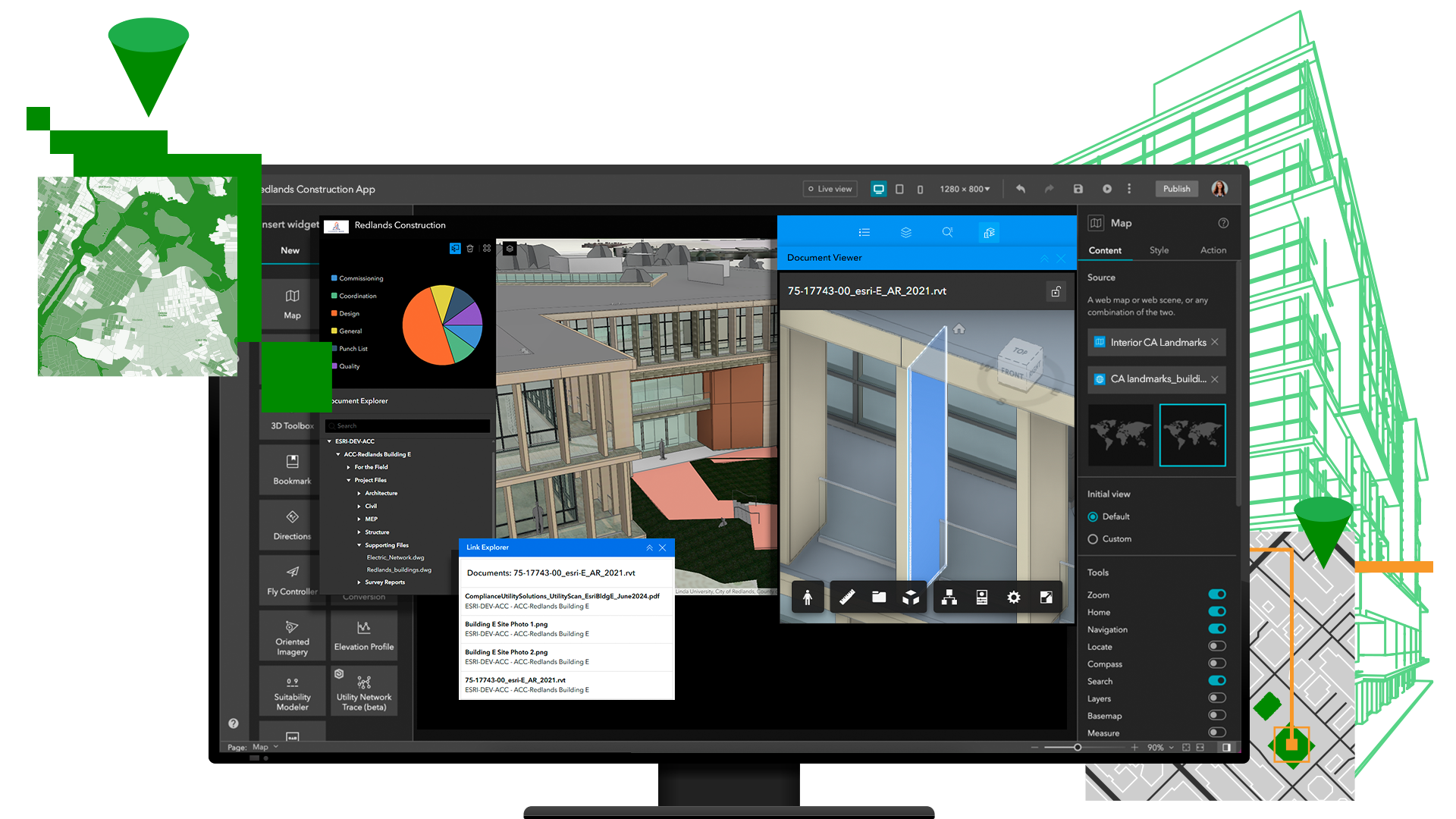
Document Explorer
Browse an index of all project documents and data stored in Autodesk Construction Cloud. This widget simplifies access to critical project files, improving transparency, and reducing time spent searching for information.
Document Viewer
View and interact with linked 3D models and 2D documents directly in your app. Whether it’s a Revit model or a computer-aided design (CAD) floor plan, users can explore design data in context—without leaving the app.
Link Explorer
Navigate through all your project data linked to features in 2D maps or 3D scenes. This widget connects spatial features and associated AEC documentation, making it easier to understand the full picture of a project.
What can you build?
The new widgets unlock a wide range of custom applications. Here are just a few possibilities:
- Client project dashboards: Branded, client-facing apps that provide stakeholders with real-time access to project progress, documents, and spatial data.
- Project information dashboards: Internal apps where users can explore portfolios of project information on a map, view associated BIM models, and access linked documents.
- Design review portals: Apps that allow teams and project stakeholders to view 3D models, share feedback, and track design changes.
- Field coordination apps: Mobile apps that help field teams access the latest drawings, models, and site photos in geographic context.
These use cases demonstrate how the new widgets can help teams move beyond paper-based documentation, static reports, and siloed tools—toward dynamic, integrated web experiences. If you can envision it, you can build it.

Get started building custom web apps
Ready to try out the new widgets? Here’s how to get started:
1. Open ArcGIS Experience Builder in ArcGIS Online, create a new app, and select a template to start. You’ll need a Creator user type or above to create apps.
2. Add widgets like Document Explorer, Document Viewer, and Link Explorer found in the map centric category. Drag and drop them from the sidebar onto the canvas, adjusting their size and placement as needed. Be sure to also add a map widget so you can connect AEC data from Autodesk to GIS features.
3. Add data to your app by selecting a web map or 3D web scene for use within the map widget. Depending on how many widgets you choose to include in your app, you can continue adding data before moving to the next step.
4. Fine-tune your app experience to display the maps, models, and linked documents relevant to your project or needs. There are two common scenarios you may want to consider for your custom app which we cover in this detailed tutorial.
5. Publish and share your app once finished and after saving. You can choose to share the app with members of your ArcGIS organization or publicly. To view the Autodesk connected widgets in published web apps, users will need a Contributor user type or above and an active Autodesk license.

Build Autodesk connected apps—your way
The June 2025 update of ArcGIS Online marks another major step forward in bridging the gap between GIS and AEC workflows. With new widgets in ArcGIS Experience Builder, teams can now build custom web apps that bring together maps, models, and documents in powerful new ways.
This enables organizations to connect data across platforms for improved information sharing, project collaboration, and decision-making. Whether you’re delivering tailored experiences to meet clients’ requirements or streamlining internal operations, these tools help you bring BIM to the browser—on your terms.
Get started with ArcGIS Experience Builder and try out the new widgets today. Coming July 13 to the developer edition of ArcGIS Experience Builder.
Don’t have an ArcGIS user type? Explore pricing or start a 21-day trial of ArcGIS Online today.
New to Esri and ArcGIS? Get started with ArcGIS for BIM and CAD.


This is a fantastic update that bridges a critical gap between GIS and AEC workflows. The new widgets in ArcGIS Experience Builder provide the flexibility we’ve been looking for—especially for visualizing BIM models and linked documentation in a fully customized web environment. Excited to begin integrating these tools into our asset management workflows!