Tech Time
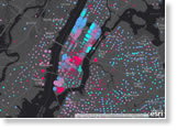
This Esri Story Map highlights a variety of predominance maps, such as election, household income, and education level maps, and shows you how to start making your own using smart mapping in ArcGIS. Explore the predominance maps.
-
Smart mapping capabilities in ArcGIS Online and Portal for ArcGIS can be used in the custom web apps that you develop. Esri's Kristian Ekenes shows you how. Read the blog.
-
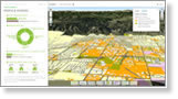
Learn how to create a dynamic 3D local scene of your city's buildings by using the new releases of ArcGIS Pro and Portal for ArcGIS. Read the blog.
-
Esri will host two webinars on how to use video and still imagery from drones, unmanned aerial systems, and unmanned aerial vehicles in ArcGIS. Sign up for the webinars.
Maps & More
-
Credentialed members of the American Institute of Certified Planners can now earn certification maintenance credits for continuing their GIS education. Read the article.
-
Get your creative mapping juices flowing. Submit up to three story maps in the Esri Storytelling with Maps contest by May 23, 2016. The grand prize: a free trip to the Esri User Conference. Enter today.

-
Data Appliance for ArcGIS plugs right into your internal, secure network to deliver preloaded imagery, basemaps, and reference layers. Order today.
The Last Word
-
Esri cartographic product engineer Lisa Berry offers a quick overview of the benefits of contributing data to the Living Atlas of the World. To learn how to furnish your information, stop by the Living Atlas of the World booth at the 2016 Esri User Conference.
Watch the video.
-
Esri's chief technology evangelist Bern Szukalski is interviewed in an episode of Geogeeks in Cars Going for Coffee. He discusses the GeoHub concept, Esri Story Map, and Drone2Map for ArcGIS. Watch the video.