
November 6, 2018 |
June 23, 2020
The UK just released a geospatial strategy report acknowledging that location data and technology make everyday lives easier. It also catalogs a great deal more potential to boost economic, social, and environmental outcomes. The document puts great weight on location intelligence to “unite and level up the country by connecting people, organisations and services.”
That quote quickly sums the importance and power of location data and geographic information system (GIS) technology to make sense of place. It also puts faith in location intelligence to guide us out of crises—including the current global pandemic and the growing specter of climate change—and to improve the economy while working to better understand ourselves.
The UK, like most countries, uses location intelligence at all levels of government to help manage all that they do. The tools underpin effective policy by quantifying constituents and monitoring the equitable distribution of resources. Infrastructure projects run on a foundation of geospatial technology, including detailed digital twins that bring a new level of efficiency to the architecture, engineering and construction industry. Disaster and pandemic responses are guided by geospatial communication from the top of the world’s largest health organizations all the way down to the boots on the ground of our first responders. Businesses rely on location intelligence to improve operations and guide strategy, and today’s uncertainties make the tools even more integral by providing a means to monitor and analyze much-changed geographies and guide strategies for reopening.
The UK believes geospatial tools and the industry can help drive the UK’s future economic recovery and growth. As a long-standing innovator in all things geospatial, the world is listening. The country’s mapmaker, Ordnance Survey, epitomizes what’s possible by leading the world in a transformation powered by automation. If the UK asserts that the time is right to unlock more potential in the geospatial industry, it’s a declaration that marks a sounding shot for a race of continued geospatial innovation.
The global COVID-19 pandemic provides yet a new level of validation about the importance of location intelligence. Immediately, the value of a map-based visualization showed the dimensions of the crisis, with the Johns Hopkins University dashboard continually showing how the virus is spreading. Every day billions of people turn to this map-based dashboard to understand trends, epicenters, spread, proximity, vulnerability, and more.
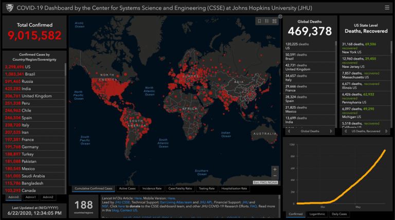
The pandemic has helped the world gain a new appreciation about the importance of geography and the value of a map for powerful communication. From the early days of the outbreak, the dashboard told the world that the virus was something new and deadly. While we all watched it spread, a map helped us all prepare, and it crystallized how the world has become so interconnected.
During this crisis, GIS users have applied their knowledge and creativity to respond and support their organizations and communities. Communities, states, and whole nations have used GIS to model forecasts and compare them against hospital capacity, to add more hospital beds where needed. We have also seen the effectiveness of ongoing geospatial monitoring to gauge the benefits of social distancing as the key intervention to avoid worst-case scenarios of spread and impacts.
Worldwide, GIS users have rallied to map the supply chain of personal protective equipment, understand the locations of our most vulnerable populations, collect food resources and convey where those most vulnerable and disrupted can get food, target new locations for testing and care facilities, and rally around essential workers and businesses.
Location intelligence has been central to the response–and will be key in the recovery.
Today, GIS is being applied to so many domains in the commercial, nonprofit and government sectors, spanning capabilities from quick data capture to monitoring operations and guiding strategy. The key functions of the toolset remain rooted in mapmaking and spatial analytics, but leaps in flexibility and ease of use have enabled whole new workflows. The flow of location information has never been more fluid.

Esri appreciates the uniqueness of this moment. Past crises have spotlighted the importance of the tools, but today’s geospatial technology has reached a much wider audience. New patterns have emerged to collect data from a distributed workforce and quickly share to provide situational awareness. Enterprises are creating new levels of linkages, using shared understanding to bring teams closer even as we social distance.
GIS is central in every Emergency Operation Center in governments and businesses, which are operating around the clock and around the world. Now as things reopen, GIS is used to understand impacts on individuals and organizations. GIS-based surveys assess all manner of disruptions and the intelligence gathered is being used to shore up vulnerable businesses and communities. With inequity top of mind, the tools are fundamental to an examination of fairness.
Advancements in data gathering, data science, and business intelligence have helped fuel the creation of the location intelligence market as a distinct subsector of the geospatial industry. This newer offshoot provides unique abilities to understand people and place. Businesses apply location intelligence to discern the proclivities of customers and to get an edge by improving the efficiency of operations.
Forrester Research is famed for its analysis of the impacts of technology on business. The firm was prescient when it made the bold call in 2011 that we’re entering a new age of the customer, with technology empowering consumers to demand more from businesses. Forrester just released a report “The Forrester Wave™: Location Intelligence Platforms, Q2 2020” that digs deeply into the players and practices used to derive customer insight. The report exclaims that now is the golden age of location intelligence.

Businesses use location intelligence to tailor and optimize the customer experience and to guide strategy and actions. The modern GIS platform’s ability to support different user types helps adapt the tool to fit many business functions. This feeds data from the whole of operations, marketing and other divisions to provide a more holistic corporate understanding. Given the pressures businesses currently face, location intelligence is more important than ever, and the tools are up to the task.
According to a blog post by James McCormick of Forrester, the evolution of location intelligence provides a key capability to bring about digital transformation. Esri echoes the feeling that the time is ripe and is proud to be named by Forrester as a leader among location intelligence platform providers.
The geospatial mindset spans science, technology, business, and governance. The new flexibility of the tools and data make cross-sector integration possible, and new levels of collaboration have emerged. During this era of increased corporate social responsibility, accelerated socio-environmental change around the world, and the need to remain vigilant during this crisis, location intelligence unites stakeholders around common causes.
As we navigate and rebound from the COVID-19 pandemic, location intelligence will help guide data-driven decisions that make sense of every place and include a greater knowledge of who we are.
Learn more about the new Forrester report and the power and value of location intelligence.

November 6, 2018 |
February 14, 2018 | Multiple Authors |

October 16, 2019 |