A few weeks ago, we published the “What’s new in geospatial AI” blog, highlighting the latest AI capabilities we’re integrating across ArcGIS, built to be secure, trustworthy, and useful. Right now, that means AI assistants, agentic AI, and AI tools and models, which include new AI premium services… But what does this mean for ArcGIS Enterprise users specifically?
ArcGIS Enterprise 12.2 is the first release of ArcGIS Enterprise to include all three, plus support for external AI applications. If enabled by your ArcGIS Enterprise administrator, assistants will help you with tasks like creating Arcade code, improving item metadata, translating your apps from one language to another, and much more. Agents will help you in orchestrating complex tasks within ArcGIS Enterprise. AI premium services will allow you to translate your content to different languages and analyze images into text. This blog covers each of these areas, outlining their basic functions, access points, and requirements for use.
Accessing AI in ArcGIS Enterprise 12.2
ArcGIS Enterprise administrators remain in full control of which AI-enabled features are available to users in the organization. New AI settings in the ArcGIS Enterprise organization settings let administrators enable AI and then choose which AI-enabled features they need. Additionally, manage external AI client access to ArcGIS Enterprise through the Model Context Protocol (MCP) for ArcGIS Enterprise.
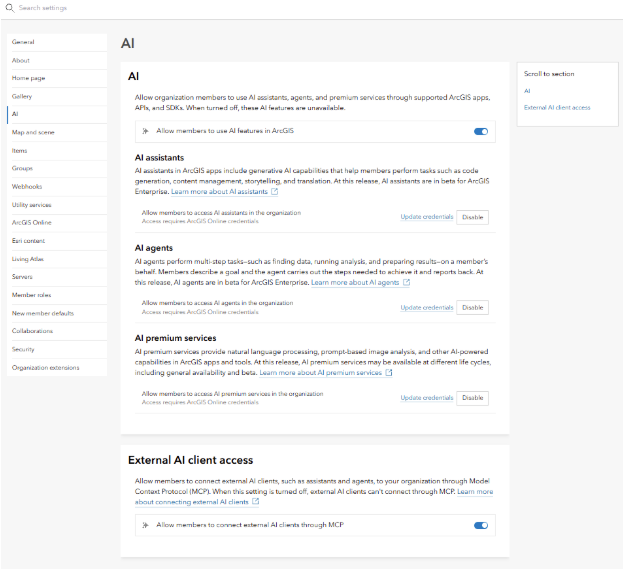
At the ArcGIS Enterprise 12.2 release, most AI features are beta features. Beta features provide an opportunity for testing and feedback while functionality is still being finalized. Using these beta features and providing feedback allows you to provide direction for the future of the feature. Beta features do have different promises of support than generally available functionality so they should be used for testing purposes only. For AI features that are in beta, Esri development teams will be able to see your prompts and data because the intention of a beta is to gather feedback to make improvements. If you’re working with sensitive data, you have the option to turn beta features off, giving you full autonomy over what’s shared and what isn’t.”
Documentation and feedback will be provided and collected in the ArcGIS Enterprise 12.2 beta feature Early Adopter Community, which is open to all users. We encourage you to join in!
Many AI features require access to ArcGIS Online and active credentials and may involve usage and credit consumption considerations. We cover these nuances later in the blog.
Trust and security are the cornerstone of ArcGIS development, and AI features are no exception. AI features rely on human-in-the-loop design and have been tested thoroughly to minimize risks while ensuring inclusivity and user control. The ArcGIS Trust Center speaks to these guiding points in more detail on the Trusted AI in ArcGIS page. Besides laying out Esri’s approach to responsible AI development, it includes a set of Transparency cards. These cards provide key details that allow customers to incorporate and use AI features responsibly.
Please note that at the 12.2 release, some transparency cards are still being constructed. These cards are completed for the assistants and agentic experiences to enter General Availability (GA).
AI assistants
ArcGIS Enterprise 12.2 includes AI assistants in many different applications. AI assistants are embedded directly into ArcGIS apps and experiences, and their sole focus is to make ArcGIS easier to use, learn, and interact with. Some assistants use natural language to turn your thoughts into actions within ArcGIS Enterprise. Others translate your work into different languages or write descriptions of images. Some even work through spoken words like the XR Viewer assistant (beta)! How you interact with an assistant depends on the context of the application where it appears.
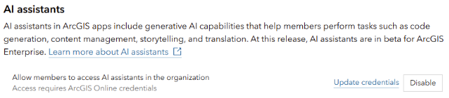
All AI assistants in ArcGIS Enterprise 12.2 are beta features. Documentation, feedback, and technical support for these assistants will be provided through the ArcGIS Enterprise 12.2 Early Access Community (EAC). For more information on beta features in ArcGIS Enterprise, see the Beta features documentation page.
To enable AI assistants in ArcGIS Enterprise 12.2, your organization must be able to connect to an ArcGIS Online organization with active credentials. Once this connection is established, an administrator must enable AI for the organization on the AI organization settings page and then turn on the AI assistants toggle. To do so, you must provide credentials for an ArcGIS Online organization that has allowed AI features, and the account must be assigned the Use AI privilege. To learn more, read the Configure AI ArcGIS Online documentation.
What you can do with AI assistants
There are 12 AI assistants in ArcGIS Enterprise 12.2. We can’t cover each in depth in this blog, but the chart below describes each assistant, where it can be found, and its basic functions.
| AI Assistant | Where it appears in 12.2 | What it does | |
| 1 | ArcGIS Arcade assistant | ArcGIS Experience Builder, Field Maps Designer, Map Viewer, Portal Home, QuickCapture, Scene Viewer, Web Editor (7) | Writes Arcade expressions from plain-language requests, for pop-ups, labels, visualizations and field calculations. |
| 2 | Translation assistant | Experience Builder, Instant Apps, Survey123 (3) | Drafts translations of survey and app text into multiple languages, so you don’t have to translate every question, label and interface element by hand. |
| 3 | Item details assistant | ArcGIS Enterprise portal | Suggests titles, summaries, descriptions, tags and field details on the item page, making content easier to find and better prepared for AI. |
| 4 | ArcGIS Business Analyst assistant | ArcGIS Business Analyst | Turns a business question into a recommended workflow, such as building drive-time areas, comparing sites or analyzing demographics. |
| 5 | ArcGIS Drone2Map assistant | ArcGIS Drone2Map | Simplifies common Drone2Map tasks and setup, helping users get from drone imagery to results faster. |
| 6 | ArcGIS Excalibur assistant | ArcGIS Excalibur | Answers plain-language questions about the feature layers in an Excalibur project and points out relevant features and insights. |
| 7 | ArcGIS Knowledge Studio assistant | ArcGIS Knowledge Studio | Helps users explore and query knowledge graphs in plain language. |
| 8 | ArcGIS Notebooks assistant | ArcGIS Notebooks | Explains, writes and troubleshoots Python code using the ArcGIS API for Python or ArcPy. |
| 9 | ArcGIS Pro assistant | ArcGIS Pro | Runs common ArcGIS Pro actions, answers documentation questions and writes ArcPy scripts, SQL and openCypher queries from plain-language requests. |
| 10 | ArcGIS Solutions assistant | ArcGIS Solutions | Matches an organization’s needs to the most suitable ArcGIS Solutions and helps with deploying and using them. This assistant can also help build solutions from scratch based on user need. |
| 11 | ArcGIS StoryMaps assistant | ArcGIS StoryMaps | Helps authors polish writing, check readability, suggest image alt text and generate color and font themes. |
| 12 | XR Viewer assistant | XR Viewer | Helps navigate through a scene, change the weather, and go to different routes with vocal commands. |
These 12 AI assistants represent how AI is leveraged within existing applications. Some appear inside ArcGIS Enterprise itself, such as the item details assistant in the ArcGIS Enterprise portal and the assistants in Map Viewer and ArcGIS Experience Builder. Others work in client applications, such as ArcGIS Pro, and use your ArcGIS Enterprise organization as the connection to ArcGIS Online. AI assistants are particularly good at taking specific tasks or needs and reasoning about the immediate next steps. But what if you need an AI function that is capable of some additional reasoning? That is where AI agents come in.
AI agents
An AI agent in ArcGIS is a goal-driven AI system that can plan and carry out multi-step geospatial work by choosing and using ArcGIS tools, services and content on the user’s behalf. It runs within the user’s permissions and the organization’s AI controls.
The key difference between an assistant and an agent is scope. An assistant is embedded in one application and helps with one task at a time, such as writing an Arcade expression. An agent works toward a goal: it plans several steps, chooses which ArcGIS tools, services and content to use, and carries the work out within your permissions and your organization’s AI controls.
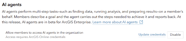
Like AI assistants, AI agents are beta features in ArcGIS Enterprise 12.2, with documentation, feedback, and support provided in the ArcGIS Enterprise 12.2 EAC. AI agents are enabled through the AI agent toggle on the AI organization settings page. To turn it on, you must provide credentials for an ArcGIS Online account in an AI-enabled organization, and as with AI assistants, the account must be granted the Use AI privilege.
There are two AI agents in ArcGIS Enterprise 12.2. First, let’s talk about the ArcGIS Instant Apps Data Explorer template. The Data Explorer template lets you interact with a map through natural language via AI-powered Natural Language GIS (NLGIS). With it, you can explore data within a map, find locations, and get guidance about the map, the app, and its capabilities. Unlike the AI assistants discussed earlier, the Data Explorer can hold a back-and-forth conversation with the user and create an app as a result of that conversation. To learn more, read the blog ArcGIS Instant Apps: Introducing Data Explorer (beta).
The other agent in ArcGIS Enterprise 12.2 is Manage AI vector embeddings. Before we dig into what this agent does, let’s define vector embeddings in the context of ArcGIS Enterprise. A vector embedding is a representation of layer titles and field metadata for all feature layers in a web map. AI agents in ArcGIS Enterprise use these embeddings to work out which layers and fields best match a user’s natural language request. The quality of layer names, field aliases, and field descriptions directly affects the quality of the generated embeddings.
The Manage AI vector embeddings agent generates these embeddings for the feature layers in your web maps so that other AI agents, such as the Data Explorer, can match a user’s natural language request to the right layers and fields. Because the embeddings are built from layer titles, field aliases and field descriptions, reviewing that metadata before generating embeddings will improve the results your users see.
AI tools and models enabled through AI premium services
The next AI feature we will discuss is AI premium services. These are hosted services, such as text analysis, image analysis and translation, that other ArcGIS products and the ArcGIS API for Python can call to do a specific job. They fall under the AI tools and models category, which has been part of ArcGIS technology for a long time: raster processing based on machine learning and end-to-end deep learning workflows through Deep Learning Studio are familiar examples. At ArcGIS Enterprise 12.2, several sets of AI premium services are being introduced. Unlike AI assistants and AI agents, which are all in beta, AI premium services are available at different lifecycle stages: some are generally available, and others are in beta.
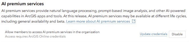
To enable them, turn on the AI premium services toggle on the organization AI settings page, using an ArcGIS Online account with either the Use AI or Use AI premium services privilege. Use of these services may consume credits in that ArcGIS Online organization.
At the time of writing, ArcGIS Enterprise 12.2 includes the following AI premium services:
| Premium service | Products besides the Python API | Status | Description |
| Text analysis | Instant Apps (Reporter template); Survey123 analysis calculations (beta) | Generally available | Uses a prompt to analyze text, for example to summarize, classify or pull key details from survey answers or report submissions. |
| Image analysis | Survey123 analysis calculations (beta) | Generally available | Uses a prompt to describe photos or extract details from them, such as text, objects or conditions. |
| Text translation | ArcGIS Arcade | Generally available | Translates text between languages, such as attribute values or labels in Arcade expressions. |
| Audio transcription (speech to text) | Survey123 analysis calculations (beta) | Beta, free until GA | Turns recorded speech, such as a field worker’s audio note, into written text. |
| File analysis | Python API only | Beta, free until GA | Analyzes the contents of files, such as documents, to summarize them or pull out information. |
| Audio generation (text to speech) | Python API only | Beta, free until GA | Creates spoken audio from text. |
AI premium services may be used either through the ArcGIS API for Python’s arcgis.ai module or as features in apps like Survey123, Instant Apps, and wherever Arcade is available.
External AI client access
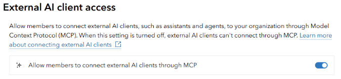
The last AI feature in ArcGIS Enterprise 12.2 is the ability to connect to external AI clients via the Model Context Protocol (MCP) for ArcGIS Enterprise, now generally available. MCP is an open standard that lets AI applications connect to external tools and data sources in a consistent way. With MCP for ArcGIS Enterprise, an external AI application can use the authoritative data and tools in your organization while respecting the permissions your administrator has set. To enable it, an administrator must configure MCP for ArcGIS Enterprise and turn on External AI client access in the organization settings.
To keep this blog focused on the features coming in ArcGIS Enterprise 12.2, we’ve written a separate blog on MCP for ArcGIS Enterprise. Be sure to read it next! And to learn more about other new features in ArcGIS Enterprise 12.2, check out this blog.
Conclusion
ArcGIS Enterprise 12.2 contains many useful AI features for your users. Whether it is an assistant, an agent, or an AI-backed premium service, we are excited to offer these tools to the ArcGIS Enterprise user community, while continuing to develop ways to curate your exact experience so that you remain fully in control. Because most of these features are beta features in this release, we are especially interested in your feedback. Please join the ArcGIS Enterprise 12.2 Early Access Community to share your experience and help shape future development.


Commenting is not enabled for this article.