Explore what’s new in the latest ArcGIS release.

ArcGIS Pro
ArcGIS Pro 2.6 is now live, and you can enjoy the all new features and improvements today. Update to ArcGIS Pro 2.6 and find rich new content and tools such as voxel layers, trace networks, Interactive suitability analysis, graphic layers, and so much more.
Prior to every release of ArcGIS Pro, the team behind the product listens and engages with community members to hear their needs. The ArcGIS Pro team is proud to say that there are over 150 enhancements and ideas from our users made within this release of ArcGIS Pro, Esri’s most powerful desktop application.
ArcGIS Pro continues its mission of bringing you the new tools, workflows, and capabilities requested by the user community and optimized for the modern GIS professional.
View video highlights, new functionality updates, and start MAPPING LIKE A PRO with 2.6 today.
Geodatabase
New additions to Geodatabase in the latest ArcGIS Pro release includes the following:
- Topology web feature layer
- Branch versioning – Reconcile by Attribute and Field Conflict Filter
- Attribute Rules view – Release columns
- OLE DB and ODBC support
- GeoPackage editing
Learn more in this blog.
ArcGIS Image Analyst
ArcGIS Image Analyst just got better! Detect categorical, relative and absolute change using time series data and image cubes. Explore new deep learning models that help simplify your work such as SuperResolution, FasterRCNN, and more. Also, if you work with motion imagery, this release has you covered.
Read all about it.
ArcGIS Aviation
This release of the Aviation Airports increases obstacle analysis capabilities with the new Light Signal and PAPI Obstacle Clearance Surfaces. More control over surface creation has been added with the ability to generate FAA18B, FAA FAR 77, and ICAO Annex 14 surfaces with displaced thresholds. The new release of the Aviation Charting further enhances your ability to produce standard aviation charts with tools for managing your aviation area of interest, applying cartographic exceptions and queries, and generating cartographic features. Creating aviation annotation has also been made easier with the new ability to generate aviation specific callouts. All these capabilities are available at 2.6 release from the Aviation ribbon or toolbox.
ArcGIS Production Mapping / ArcGIS Defense Mapping
This release introduces new production workflows for field editing, data ingest and automated cartography. A new Geoprocessing tool allows users to generate product layouts for map templates released with the product files. Generalization tools have been enhanced, including adding new generalization rule files for MGCP. A new tool for replacing colors in your maps, styles, and layouts has been added. Additionally, all layout templates for ArcGIS Defense Mapping users now have SPOT color PDF export capabilities.
Learn More about Production Mapping
Learn More about Defense Mapping
ArcGIS Data Reviewer
This release brings new and enhanced capabilities for automating quality control workflows implemented using Attribute rules. These include new checks that identify nonlinear segments (such as arcs and curves) in polyline and polygon features (Nonlinear Segment) and validate relationships between linear-referenced events (Event on Event). Enhancements to the Feature on Feature check now enables the validation of both spatial and attribute relationships between features. An example use case is in water utilities, the check is used to detect valves that contain a different diameter value than that of the connected line. Leveraging validation services available in ArcGIS Enterprise 10.8.1, features which fail validation can be reviewed and corrected using ArcGIS Pro or through custom web applications.
ArcGIS Pipeline Referencing
This current release includes new tools and capabilities to support intersections and the ability to view the LRS dataset and configuration.
Intersections:
- You can now configure intersection feature classes as well as generate and update intersections in ArcGIS Pro. Unlike earlier intersection support in ArcMap, ArcGIS Pro generates only one intersection point at each location.
- Performance has been improved when generating intersections.
- You can distinguish intersections at grade (or not at grade) with the option to z-enable your intersection feature class as well as to define z-tolerance.
Viewing LRS hierarchy/configuration has been added:
- You can view the hierarchy in your LRS dataset using the Catalog pane to determine which types of networks exist in your LRS and which events are associated with each network.
- You can view the LRS hierarchy from the Contents pane when adding any LRS items (minimum schema, network, event, or intersection) to the map.
Additionally, these new capabilities within ArcGIS Pro provide full equivalency with the Pipeline Referencing capabilities within ArcMap. The ArcMap extension for Pipeline Referencing has now been deprecated; Pipeline Referencing users only need ArcGIS Pro moving forward.
ArcGIS Roads and Highways
The current release of Roads and Highways includes tools and capabilities to support routes with physical gaps and generation and maintenance of intersections as well as the ability to view LRS dataset and configuration.
Physically gapped routes:
- This feature provides the ability to configure a gap calibration method based on your business rules as well as support for the configured method throughout network editing activities such as create and realign.
Intersections:
- You can now configure intersection feature classes as well as generate and update intersections in ArcGIS Pro. Unlike earlier intersection support in ArcMap, ArcGIS Pro generates only one intersection point at each location.
- Performance has been improved when generating intersections.
- You can distinguish intersections at grade (or not at grade) with the option to z-enable your intersection feature class as well as to define z-tolerance.
Viewing LRS hierarchy has been added:
- You can view the hierarchy in your LRS dataset using the Catalog pane to determine which types of networks exist in your LRS and which events are associated with each network.
- You can view LRS hierarchy from the Contents pane when adding any LRS items (minimum schema, network, event, or intersection) to the map.

ArcGIS Enterprise
ArcGIS Enterprise 10.8.1 is a long-term support release that builds upon ArcGIS Enterprise 10.8 and introduces new features, apps, and improved functionality in the product. Here are some highlights:
- Updated ArcGIS Enterprise portal user interface including item creation dropdown, updates to organization settings, updated user profile, and more.
- Map Viewer beta, the next-generation Map Viewer built on ArcGIS API for JavaScript 4.x, offers faster, more flexible and immediate symbology and filter changes as well as new options for smart mapping and popups.
- Email support allowing organizations to set up their SMTP server for automatic email notifications for certain events like license expirations.
- Streamlined content migration between ArcGIS Enterprise deployments via the REST API and the ArcGIS API for Python.
- Next-generation ArcGIS StoryMaps and the Storyteller user type is now available in ArcGIS Enterprise.
- ArcGIS Experience Builder is a new app users can leverage to create web experiences that combine tools, text, media, 2D and 3D data on any device.
- New features in ArcGIS Enterprise SDK, such as support for utility network datasets in SOEs and SOIs, building image service SOIs, using shared instances for services with SOIs and SOIs, and integration with Maven for Java SOE and SOI development.
See what’s new in ArcGIS Enterprise 10.8.1.

ArcGIS Mission
ArcGIS Mission is a situational awareness and mission-management software solution that provides organizations with a comprehensive understanding of the operating environment. Mission delivers dynamic, real-time information to team members in the field, and allows field personnel to easily relay messages and observations to each other and to the command center.
The ArcGIS Mission 10.8.1 release enhances mission management and mission response capabilities. Here’s what’s new:
- iOS is here: ArcGIS Mission released in iOS, providing another platform to use.
- One-click dashboards: The new ArcGIS Mission Manager experience provides a new experience to enable executives to monitor the mission activities they care about most in the familiar view of ArcGIS Dashboards.
- Assign tasks: Mission managers can now assign tasks to mission members to perform a focused job function based on a set of instructions during active missions.
- Report observations with new tactical summary reports: Responders can provide quick, tactical, in-the-field summary reports at any time to everyone in the mission.
ArcGIS GeoEvent Server
ArcGIS GeoEvent Server 10.8.1 updates include usability improvements in GeoEvent Manager such as a new monitoring page and enhanced input and output creation workflows, geofence insight improvements, and expanded documentation that has new topics and information on deploying and configuring GeoEvent Server.
Learn more in this blog.
ArcGIS GeoAnalytics Server
New at 10.8.1, Geographically Weighted Regression finds a home in ArcGIS GeoAnalytics Server’s Analyze Patterns toolset. Use linear regression to model spatially varying relationships within variables in your big data by leveraging the distributed computing capability of ArcGIS GeoAnalytics Server.
See documentation.

ArcGIS Notebooks
In ArcGIS Notebook Server within ArcGIS Enterprise 10.8.1, you can easily set up tasks and have them scheduled to run on a specific day or at a specific time, using the new and intuitive Tasks feature. This easy-to-use scheduling interface enables you select a specific time/day slot to automate and execute workflows within ArcGIS Notebook Server, without needing user interaction. Want to see this in action? Watch the video.
ArcGIS Image Server
ArcGIS Image Server, the ArcGIS Enterprise server role that provides a fast, efficient way to process, analyze, and share massive collections of imagery and rasters, has many new updates and enhancements this release. In 10.8.1, you will experience improvements to creating imagery content, new offline functionality for ortho maker (a capability within ArcGIS Enterprise that supports map production from imagery), and an assortment of new raster analysis functions and tools accessible from the Map Viewer, ArcGIS Pro, and in the ArcGIS REST API.
Read what’s new.
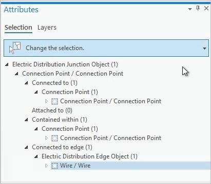
ArcGIS Utility Network
Updates and improvements to the utility network in this latest release include new capabilities that support non spatial objects, changes to error management, the trace framework, and new options to improve subnetwork management.
Learn more in this blog.
ArcGIS for INSPIRE
This release adds geodatabase templates and operational capabilities to support ‘Environmental Management Facilities’ and ‘Administrative and Social Government Services’ schema of Utilities and Governmental Services (US) data theme and the ‘Hydrogeology’ application schema of the Geology (GE) data theme. Geoportal Server Catalog now includes support for the CSW 2.0.2 end point and INSPIRE Metadata (v2.0.1) for creating and updating metadata following the INSPIRE metadata technical guidance TG 2.0.
ArcGIS Workflow Manager
At 10.8.1, ArcGIS Workflow Manager introduces a new service-driven architecture focused on web-based workflows such as digital submissions and approvals, and web-based data editing and QC. This deployment is in addition to the existing geodatabase version which continues to assist organizations with multi-user data editing and management challenges.
ArcGIS Maritime
At 10.8.1, several enhancements have been made to Maritime Chart Service and Products on Demand (PoD) capabilities in ArcGIS Maritime. These include added support for custom symbology and for creating Zones of Confidence Diagram. The PoD web app for Custom Product and Fixed Product are separated into two user interfaces. Additionally, geoprocessing tools for importing, exporting, validating and distributing S-57 Electronic Navigational Charts was included in ArcGIS Pro 2.6.

ArcGIS Online
Map Viewer Beta, the new Map Viewer in ArcGIS Online, was updated with some highly requested features including layer groups and cluster labeling. For a complete list of the new features, check out this article.
The June update of ArcGIS Online brought a new home page editor, instant app configuration experience, bulk item transfer, additional reports for administrators, and many more capabilities. This article introduces you to all the latest features in ArcGIS Online.
ArcGIS Apps

ArcGIS Earth
ArcGIS Earth is an interactive 3D experience for users to plan, visualize, and evaluate events on the globe. ArcGIS Earth provides situational awareness of an environment on desktop and mobile for improved decision-making. Ingest data in different formats, including 3D models, KML, TXT, and open services from ArcGIS or with a URL, to explore areas of interest in 3D. Manipulate KML in its entirety to understand changing circumstances. ArcGIS Earth is a free and easy-to-use tool to quickly fuse, manipulate, and collaborate with 3D data for research, planning, supporting time sensitive briefings, and graphic presentation. ArcGIS Earth 1.10.1 released with protected services.

ArcGIS Excalibur
ArcGIS Excalibur is a web-based imagery application that allows users to search, discover, and work with imagery. Imagery and geospatial workflows that have traditionally been separate are now seamlessly integrated and easily accessible to analysts using ArcGIS Excalibur. With the latest release, Excalibur provides a more streamlined imagery workflow, including: Updates to imagery project workflows, enhancements to the way you create and share reports-including in Microsoft PowerPoint, and the ability to publish hosted imagery. This release makes image analytics and image exploitation more accessible than ever.
ArcGIS StoryMaps
The new ArcGIS StoryMaps is now available in ArcGIS Enterprise 10.8.1. Since ArcGIS StoryMaps launched last July, lots of new features have been added, and Enterprise users can now access all the exciting new functionalities in Esri’s next-generation storytelling tool, including Block Palette, Sidecar, Express Maps, and more.
See what’s new in this blog.

ArcGIS Field Maps (Beta)
ArcGIS Field Maps is the next-generation field app, available on iOS and Android devices, that will replace ArcGIS Collector, ArcGIS Explorer, and ArcGIS Tracker. Over time, it will incorporate ArcGIS Workforce and ArcGIS Navigator, delivering robust field capabilities all in a single app.
Field Maps will combine the following capabilities into one app that is easy to use and simple to deploy:
- Simple map viewing and markup
- High accuracy field data collection and inspection
- Battery-optimized location tracking
- Work planning and task management
- Turn-by-turn navigation
Capabilities will be released in 3 phases and the first phase of ArcGIS Field Maps is in beta now. Please join the early adopter program to learn how ArcGIS Field Maps will transform the way you do field work.
When ArcGIS Field Maps is released this fall, a patch to ArcGIS Enterprise 10.8.1 will be made available so that you can install the Field Maps web app on your Enterprise portal.
ArcGIS Workforce
ArcGIS Workforce is a mobile app solution that uses the power of location to coordinate your field workforce. It integrates work management to reduce reliance on paper and provides everyone with access to the authoritative data they need. ArcGIS Workforce is designed to help you reduce errors, boost productivity, and save money.
The recent release of Workforce supports offline workflows, enabling your mobile workers to complete assignments in the field, whether they have an internet connection or not. Additional updates include:
- User experience updates
- Get directions from any navigation app on your device
- Toggle layer visibility with the layers tool
- View tracks from ArcGIS Tracker (iOS only)
The ArcGIS Workforce web app is not included as part of ArcGIS Enterprise. A separate patch for ArcGIS Enterprise 10.8.1 will be made available so that you can install the Workforce web app on your Enterprise portal.
ArcGIS Collector
ArcGIS Collector is a mobile data collection app that makes it easy to capture accurate data and return it to the office. Fieldworkers use web maps on mobile devices to capture and edit data. ArcGIS Collector works even when disconnected from the Internet and integrates seamlessly into ArcGIS.
Recent updates to Collector on the Android platform include high accuracy updates that achieve parity with the Classic version as well as support for signing in using PKI. On the iOS platform, support for attaching PDFs, Excel documents and Word documents to observations has been added along with the ability to use app links to update existing feature attributes.
For more information, see What’s new in ArcGIS Collector.
ArcGIS Explorer
Take your maps with you everywhere you go with ArcGIS Explorer, a mobile app for iOS and Android, and now available on Windows 10. Take your GIS with you in the field, work offline, and add shareable notes and markup.
Explorer recently updated on all platforms. The Windows and Android platforms now support signing in using PKI. For more information, see What’s New in ArcGIS Explorer.
ArcGIS Experience Builder
ArcGIS Experience Builder is now in ArcGIS Enterprise 10.8.1. ArcGIS Experience Builder allows users to create web experiences using flexible layouts, content, and widgets that interact with 2D and 3D data. Users can generate reusable templates, user enterprise logins, and more. Learn more about Experience Builder features in ArcGIS Enterprise.


Article Discussion: