How Esri Has Simplified ArcGIS
The past five years represent the most sustained and systematic simplification effort in ArcGIS history. It has not been a single dramatic rebrand or a wholesale re-architecture that left existing workflows behind. Instead, it has been a persistent, release-by-release commitment to reducing friction in multiple ways. In the interface, in the licensing model, in the way apps get built, in the way analysis gets done, and in the way users interact with the software itself. The result is a GIS platform that is meaningfully easier to use today than it was five years ago, at every level of the organization, without sacrificing any of the depth that makes it worth using in the first place.
Here is the story of how that happened.
The Pattern Behind the Progress
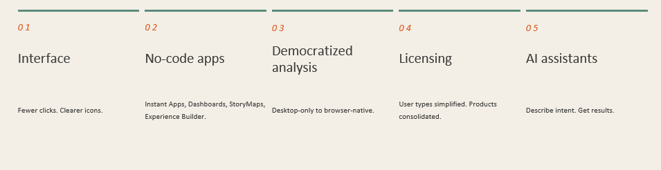
Looking across five years of releases, the simplification story is not a single innovation but a layered, consistent strategy. At Esri, we have pursued simplicity through distinct mechanisms simultaneously.
The first is interface simplification. The steady removal of visual noise, the introduction of clearer icons and shapes, the decluttering of ribbons and panes, the redesign of workflows so that common tasks require fewer steps. This work may not be glamorous but it is consequential, and it shows up in every major experience from Map Viewer to ArcGIS Pro to ModelBuilder.
The second is the no-code and low-code ecosystem. The consistent investment in tools like Experience Builder, Instant Apps, StoryMaps, and Dashboards that let anyone, not just developers, build applications. This investment has never slowed. Experience Builder alone shipped more than twenty major updates between 2021 and early 2026.
The third is the democratization of analysis. Moving sophisticated spatial processing from specialized tools that only work on a desktop to browser-native interfaces accessible to anyone in an organization. The arc from the Analysis widget in Experience Builder (2023) to ModelBuilder general availability in ArcGIS Online (2025) to ModelBuilder web tool publishing (2026) is one of the most important simplification stories.
The fourth is administrative and licensing simplicity. Changes like the 2024 user type overhaul have reduced the complexity of deploying and managing ArcGIS across an organization, making GIS accessible to more staff without requiring extensive configuration by administrators. In parallel, we have streamlined the product portfolio by consolidating offerings and removing barriers to adoption, ensuring users more easily understand, access, and apply the capabilities and content they need without unnecessary complexity.
The fifth is AI-assisted interaction. The growing set of natural language interfaces that let users describe what they want rather than having to navigate features and functions. This is the newest and fastest-evolving dimension of simplification, and it points clearly toward where the experience is heading.
Let’s explore some of the details over the years.
2021 – 2023 – A New Map Viewer and the No-Code App Revolution
The current transformation began visibly in 2021 with the launch of the redesigned ArcGIS Online Map Viewer. Our product designers spent years listening to feedback about the previous Map Viewer’s cluttered interface, and the new version reflects a clean-sheet rethinking of how map authoring should feel. Interface enhancements include a layer switcher that let users configure multiple layers in rapid succession without moving the mouse across the screen, a full-screen mode that hides the interface entirely when a clean map view is needed, and a general reorganization that makes common tasks predictably accessible. The new Map Viewer is faster to use, with a layout built around how people work rather than around how the underlying technology is organized.
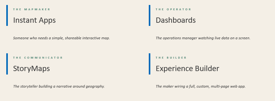
The broader no-code and low-code ecosystem has taken shape around four core tools: ArcGIS Instant Apps, ArcGIS Dashboards, ArcGIS StoryMaps, and ArcGIS Experience Builder. Each serves a different kind of non-developer user. The person who needs a simple, shareable interactive map; the operational manager who wants live data on a screen; the communicator who wants to tell a story with geography; and the builder who wants a fully custom multi-page web application. Together, they cover nearly every use case that previously required custom development or deep GIS expertise.
2024 – Simplified Licensing, Products and Interfaces
If 2021 through 2023 were about building the tools, 2024 was about removing the barriers to accessing them.
In 2024, we overhauled ArcGIS user types to offer expanded capabilities across desktop, web, and mobile environments, designed to give users support and flexibility to work from anywhere, on any device. This is simplification at the organizational level. The GIS administrators no longer need to puzzle through complex permission matrices to figure out what a new employee can access. The most common and needed capabilities are available by default.
On the product side, Experience Builder’s 2024 release introduced Express mode as a simplified app-building interface that reduces the number of decisions a user needs to make to get from blank canvas to working application. This has led to Experience Builder becoming one of Esri’s most utilized products as more experiences are being built and used by broader audiences. The Q4 2024 release of ArcGIS Pro introduced the Simplified Ribbon as an option to declutter the ArcGIS Pro workspace by presenting a slim view of the ribbon with recognizable icons, giving power users the extra screen real estate they wanted without hiding the full command set. Pane management also improved, with icons introduced for each panel to make them easily recognizable and differentiated from one another. These are the kinds of changes that longtime ArcGIS Pro users had been requesting for years, and they reflect the same philosophy driving simplification across the rest of the platform: listen to the people doing the actual work and remove the friction that is slowing them down.
2025 – AI Enters the Workflow, ModelBuilder Goes to the Web, and Products Merge
By 2025, the no-code and low-code foundation was solid enough that Esri could begin building something transformative on top of it. AI assistants that accept plain language as input and deliver GIS results as output.
The AI assistant initiative, previewed in late 2024 and expanding significantly throughout 2025, brought natural language interaction to workflows that had previously required users to know not just what they wanted to accomplish, but the specific tool, panel, or configuration option that would accomplish it. For data collection, cartographic labeling, translation, app creation, coding, and storytelling, users can now describe their intent conversationally and receive guided assistance toward a result. The barrier between “what I want” and “the tool that does it” shrink to a text box.

The May 2025 release of ArcGIS Pro added semantic search capabilities and tool suggestions directly within ModelBuilder, allowing users to find the right analytical tool by describing what they want to do rather than by remembering a tool’s exact name. The same release streamlined deed dimension extraction with a new COGO (Coordinate Geometry) Reader and enhanced collaboration through portal projects both of which are productivity improvements aimed squarely at reducing the time between data and decision.
ModelBuilder itself, the visual workflow builder that lets GIS analysts chain together spatial processing steps without writing code, reached general availability in ArcGIS Online in June 2025. For the first time, users can design, run, and share complex, multi-step spatial analysis workflows entirely within the browser, without installing desktop software. The arrival of ModelBuilder in ArcGIS Online was a milestone in Esri’s democratization effort: it moves professional-grade analytical capability from a tool that requires a desktop installation to one that requires only an internet connection.
We continue to simplify the ArcGIS experience by restructuring how extensions are packaged and delivered. Over time, certain products that addressed closely related use cases evolved independently, even though they relied on the same underlying tools, workflows, and user experiences. By consolidating these offerings into unified products, we reduce duplication and clarify how customers discover and adopt the capabilities they need. One example of this is the consolidation of ArcGIS Production Mapping and ArcGIS Defense Mapping into ArcGIS Topographic Mapping, bringing together similar map production workflows under a single, clearly defined extension tailored for both civilian and defense mapping needs. This was introduced in the releases of ArcGIS Pro and ArcGIS Enterprise in Q4 2025.
A similar approach is being applied to linear asset management, where ArcGIS Roads and Highways and ArcGIS Pipeline Referencing, two products designed to solve similar problems across different industries, have been unified into ArcGIS Linear Referencing. This simplifies ArcGIS by presenting a single product that applies to transportation, utilities, and other infrastructure domains. This change will be available in the releases of ArcGIS Pro and ArcGIS Enterprise in Q4 2026.
We have also removed barriers to entry by eliminating separate licensing for indoor positioning. ArcGIS IPS will no longer be sold as a standalone extension and will instead be included natively within ArcGIS, significantly lowering the upfront infrastructure cost required to deploy and maintain an indoor positioning system. Together, these changes reflect a consistent strategy: simplifying not by reducing capability, but by organizing, packaging, and delivering it in a way that is easier to understand, access, and use.
2026 – Analysis for Everyone, AI Everywhere, and a Redesigned Developer Kit
The simplification story reached a new chapter in early 2026, with a release that completed one of the most consequential transitions in ArcGIS history.
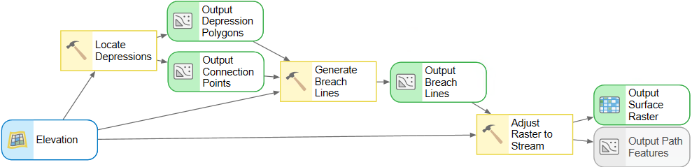
In February 2026, we announced that ModelBuilder workflows can now be published directly as web tools in ArcGIS Online. The multi-step workflows designed in ModelBuilder can now be deployed as streamlined analysis tools accessible directly within Map Viewer, Experience Builder, and other web applications. The result is that custom-built spatial analysis is no longer confined to GIS specialists. It is now accessible across any organization, allowing anyone to run powerful, standardized workflows with just a few clicks.
This is the culmination of a five-year arc. In 2021, no-code app building was the promise. In 2023, no-code analysis widgets put analytical power into those apps. In 2025, ModelBuilder became browser-native. And in 2026, the models built by GIS specialists could be packaged and deployed so that non-specialists could run them. The entire analytical pipeline, from design to deployment to use, has been democratized.
The AI assistant lineup expanded further in early 2026, with the addition of the Notebooks assistant (helping users work with spatial data programmatically), the Solutions assistant (helping organizations discover and deploy the right pre-built ArcGIS Solution, in multiple languages), and the Item Details assistant (making it easier to document and find data within an organization’s portal). The February 2026 AI update added a new role-based privilege for enabling AI assistants across an organization and introduced an Early Adopter Community framework that puts users in a direct feedback loop with our product teams building the experiences.
For developers, the ArcGIS Maps SDK for JavaScript completes its full transition to a components-based architecture in version 5.0, enabling agentic web mapping applications where users can interact through conversational prompts. The components model makes it easier to build custom applications by encapsulating complex GIS functionality into configurable, web-standard components and explicitly includes UI simplification as a first-class design consideration, with configuration options for controlling what elements appear and how users interact with them.
What It All Means for Your Organization

The practical implication of five years of simplification is that ArcGIS in 2026 is a fundamentally different proposition from ArcGIS in 2021. Not just in what it can do, but who can do it across any size organization or industry.
In 2021, building a public-facing web application with ArcGIS required either a developer or a GIS specialist with web configuration skills. Today, anyone with ArcGIS Online can build and publish an application using Express mode in Experience Builder or a template from Instant Apps.
In 2021, running a multi-step spatial analysis required ArcGIS Pro, a desktop license, and the depth of knowledge needed to chain geoprocessing tools. Today, that same analysis can be designed in a browser using ModelBuilder in ArcGIS Online, saved as a web tool, and deployed so that any authorized user in the organization can run it with a few clicks.
In 2021, finding the right ArcGIS tool for a task meant knowing the tool existed. Today, using natural language, an AI assistant can locate it, suggest alternatives, and guide the user through configuration.
The gap between the capability of the platform and the capability of a typical user has never been smaller. GIS work that once required months of training can now be done by someone who is new to ArcGIS. Esri has invested in making the front door wide, the hallways clear, and the tools intuitive once you are inside.
That is the story of the last five years. And based on the trajectory of that story, the next five look even more promising.
Explore what ArcGIS can do for you at esri.com/arcgis.






Commenting is not enabled for this article.