Store
|
Contact Us
|
Careers
Home
Industries
Products
Training
Support
Services
Events
News
About
About Esri
Careers
Esri Video
Partners
ArcNews Online
[an error occurred while processing this directive]
SPRING 2008
COVER STORIES
T-SHIRTS WORLDWIDE
Now with exclusive online-only articles.
Previous Issues
Winter 2007/2008
Fall 2007
Summer 2007
Spring 2007
GIS Heroes and Pioneers
have made a difference in the world by applying a GIS solution to a community problem.
Technology and Trends Series Articles
focus on cutting-edge concepts from the top academicians in their fields.
|Includes Supplemental Podcast|
What's Coming in ArcGIS Server 9.3
Dynamics GIS: Recognizing the Dynamic Nature of Reality
New South Wales Uses GIS for Accurate Cadastral Modeling
: Railway Network Upgrading with ArcGIS Survey Analyst
NGA: Providing On-Time Geospatial Information
CDM Gains Significant Time Savings from Automated Data Management
: QA/QC Simplified with GIS
Esri Enterprise Image Management System
GIS for Sub-Saharan Africa
Surveying with GIS
Finland, Canada, CambodiaEsri T-Shirts Glow
T-shirt Photos from Previous Issues
T-shirts Galore
: Archive of all Previous T-shirt pages
"Crossing Borders" Series Articles
by AAG Executive Director Doug Richardson
"Managing GIS" Series Articles
by leading members of URISA
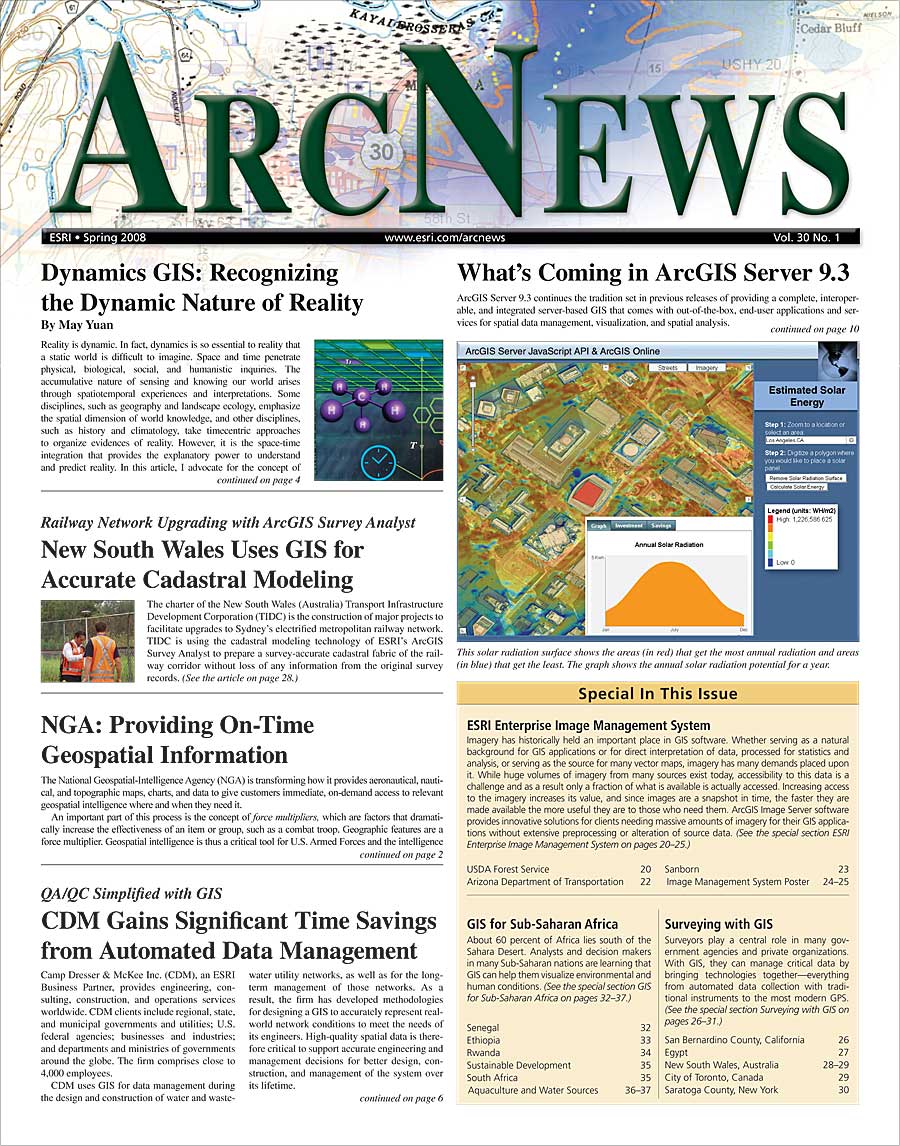
GIS PRODUCT NEWS
Esri ENTERPRISE IMAGE
MANAGEMENT SYSTEM
(cont'd)
GIS COMMUNITY NEWS
ArcGIS Server 9.3 Offers New and Enhanced Support for OGC Standards
|Includes Podcast|
Improve Marketing Analyses with Business Analyst Online
New Features in ArcGIS Engine 9.3 Coming Soon
Business Analyst Online Private Label Simplifies Research
GIS IN ACTION
Conserving Bolivia's Critical Resources
: GIS Helps Gauge Land Change Effects on the Nation's Endemic Biodiversity
Rangeland Health Data Collection and Analysis Improved with Mobile GIS
|Online Only Article|
Making Louisiana State University a Storm Disaster-Resistant School
Michels Corporation Improves Collaboration and Communication
: International Engineering and Construction Contractor Uses GIS to Better Serve Its Divisions and Customers
Landslides Studied by Japan Researchers
: Causes Analyzed with GIS—Geology and Geomorphology Probed
Centralizing One-Call Requests with GIS
: Bluewater Power Distribution Corporation Streamlines Ticket Processing
Communicating Ocean Science with GIS
: The Galathea 3 Expedition Included 48 Different Research Projects on Both Land and Water
|Online Only Article|
Impact of Climate Changes on Gray Whale Feeding Grounds Tracked with GIS
Data Provider Serves Up Petroleum Info
: Single, Complete, Reliable Reference Set for United Kingdom's Continental Shelf
Esri Business Partners' Offerings to the GIS Community
Esri ENTERPRISE IMAGE
MANAGEMENT SYSTEM
USDA Forest Service Delivers High-Quality Imagery Within Seconds
: Enterprise GIS-Level Imagery Management System Streamlines Agency
Seamless Imagery for Arizona Department of Transportation
: ArcGIS Image Server Mosaics and Processes Visual Information On the Fly
Sanborn Serves Imagery Solutions
: ArcGIS Image Server Provides Streamlined Imagery Production, Increased QC Accuracy
Image Management System Poster
[PDF]
SURVEYING WITH GIS
|Includes Podcast|
Surveyors Sift Through Fire Damage
: ArcGIS Survey Analyst Aids Fire Recovery in San Bernardino County, California
Egypt Launches Parcel-Based Deeds Registry to Spur Mortgage Market
: Manual Registry Index Streamlined with GIS
Railway Infrastructure Development in New South Wales
: Accurate Cadastral Modeling with ArcGIS Survey Analyst
-
The Benefits of an Accurate Survey Data Model
The City of Toronto, Canada
: Streamlining Maintenance
Lake Management GIS
: Mobile GIS Provides Application Development Interface for Collecting Bathymetry Data for the Entire Lake Bed
2008 Esri Survey & Engineering GIS Summit
GIS FOR SUB-SAHARAN
AFRICA
Early Warning Planning for Mosquito-Borne Epidemics
: GIS, High-Resolution Remote Sensing Help Evaluate Degrees of Risk in Senegal
Planning Education Projects in Rural Ethiopia Using GIS
Teaching GIS at Rwandan Secondary Schools
Crossing Borders: A column by Doug Richardson
Global Dialogues: GIScience and Sustainable Development in Africa
South African Educators Teach GISWith or Without Computers
: Huge Differences Exist Between Urban and Rural Schools
GIS Gateway for Aquaculture and Fisheries
African Water Resource Database
: Helping a Continent Cope with Hunger and Malnutrition
Making the Most of the 2008 Esri International User Conference
: The Latest Highlights and Ways to Get Involved at the 28th Annual Esri UC
Exclusive
ArcNews Online
Articles
Learn About GIS for Everyday Life at the 2008 Esri EMEA UC
: Upcoming Combined International User Conference to Explore the Future of Geospatial Technology
GIS Hero
Commissioner Randy Johnson Evangelizes Importance of GIS at Local and National Level
Managing GIS
The Evolution and Use of GIS in Local Government
URISA Leadership Academy
Attendees Get a Glimpse of ArcGIS 9.3, Glean Insights from Software Designer Alan Cooper
: A Look Back at the 2008 Esri Developer Summit
|Includes Podcasts|
ArcGIS Server Code Challenge Winners Revealed at 2008 Esri Developer Summit
Thought Leaders Come Together to Explore GIS Business Opportunities
: 20th Annual Worldwide Business Partner Conference Draws More Than 700 Attendees
Motivated Students Achieve Amazing Results in a Small Rural County
: Publishing an Informative, Full-Color Mapbook
GIS Day Shows How Geographic Knowledge Is Essential in Our Daily Lives
College Students Use GIS in Business Intelligence Competition
Teach Analysis and Spatial Thinking Skills with GIS
: Our World GIS Education Books Help Educators
|Includes Podcasts|
New Training and Education Offerings from Esri
Career Opportunities at Esri
Listen to Esri Podcasts
Free Esri Publications
GIS Greatest Hits
: Free Booklets