Around 2013, a cacao company purchased thousands of acres of land deep in the Peruvian Amazon rain forest. When observers began to question how the land was being used, spokespeople for the company, United Cacao, said no pristine forests had existed where the company established cacao plantations in 2013.
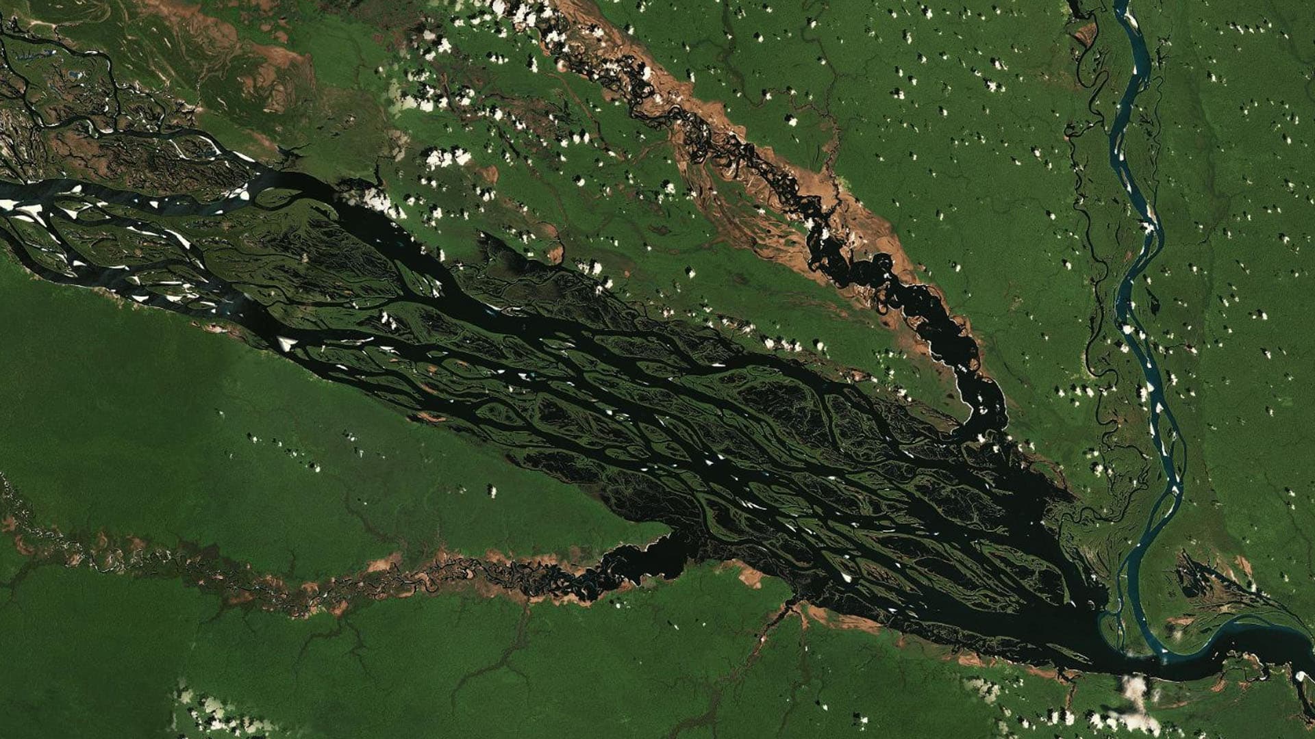
Satellite imagery and data analysis conducted by ecologist Matt Finer told a very different story, as reported by the conservation publication Mongabay. Overhead visuals of the region in 2012 showed a blanket of green—an expanse of old-growth, closed-canopy rain forest that supported biodiversity and helped keep tons of carbon out of the atmosphere.
An image of the same section of rain forest in August 2013 showed large brown strips and squares sliced out of the green—about 5,000 acres of cleared land. Seen side by side, the images challenged United Cacao’s claims that the land had been covered in secondary vegetation when the company bought it.
Questions about United Cacao’s use of the land led to the resignation of the company’s CEO and several executives and resulted in the London Stock Exchange’s Alternative Investment Market (AIM) delisting the company. Some of the satellite imagery analyzed by Finer, who serves as director of the Monitoring of the Andean Amazon Project (MAAP), was used to secure prison sentences for individuals connected to the venture.
Legal battles over United Cacao’s actions continue, but the visual evidence of the land’s abrupt transformation remains hard to refute. More broadly, the repercussions for United Cacao point to why many companies are coming to rely on geospatial analysis and remote sensing to better understand what goes on in their supply chains and operations, and decrease the risk of damaging practices.
United Cacao Case Underscores Need for Supply Chain Transparency
Pressure from consumers and the threat that climate change poses to business continuity are prompting executives to monitor supply chains with more vigilance to avoid practices like deforestation.
From fashion retail to the diamond trade, there’s a new emphasis on transparency and traceability. Consumers are holding companies responsible for their sourcing methods, with research showing that 94 percent of buyers are more likely to show loyalty to brands that practice supply chain transparency.
The demand for sustainable operations has led top business leaders to search out cutting-edge technology that can align practices with regulations and customer expectations. Many are using a geographic information system (GIS), paired with satellite imagery and other remote sensing data, to meet these goals. Analysts and executives use GIS smart maps and dashboards to see data on raw materials in the context of location and visualize the links in complex global supply chains.
Artificial intelligence, in the form of machine learning, is making it possible to study imagery for millions of acres at a time, spot harmful practices, and even predict which areas are most susceptible to threats like deforestation. With more companies embracing corporate social responsibility, the location intelligence produced by GIS is proving to be indispensable in ensuring that business leaders can back up promises with action.
Hard Data, Hard Truths
Finer and his colleagues relied on a number of data sources and analysis techniques to show that United Cacao had misled the public about the state of the land in the Amazon, according to Mongabay‘s reporting. One of the earliest clues that something was amiss came from NASA Landsat satellite imagery. When Finer examined historical Landsat records dating back to 1985, it became evident that the section of forest in question had remained virtually unchanged for decades until logging began in 2013 at United Cacao’s behest.
[For more on how GIS technology acts as a wayback machine for imagery of the globe, read this article.]
Finer’s team dug deeper, conducting an NDVI analysis, or normalized difference vegetation index, which qualifies how much biomass an area contains. Densely wooded rain forests, for example, have higher NDVI values than scrublands. By comparing the history of the plantation site with an adjacent section of protected forest, Finer was able to demonstrate that prior to 2013, both areas had the same NDVI values. It was another layer of evidence that pristine rain forests had existed before United Cacao entered the region. The historical levels of carbon in the area, measured through light detection and ranging (LIDAR) data, backed up the conclusion.
Finer and the MAAP team have since used satellite imagery and GIS to disrupt illegal mining in multiple countries in the Amazon region.
Intelligence-Driven Accountability at United Cacao
Were it not for the dramatic visuals and location intelligence surfaced by analysis of near real-time satellite imagery, United Cacao’s claims might have been difficult to disprove. It’s the sort of fraught situation that has convinced companies across industries to use location data and analysis to protect themselves from fraud and bad actors.
Insurance companies, for instance, use GIS technology in a similar way to investigate false claims. If a policyholder argues that home damage occurred during a storm, remote sensing data might show that damage predated the weather event, or that the storm never reached that neighborhood.
For firms that rely on shipping networks and supply chains far too large to be monitored only by the human eye, GIS-based dashboards are proving essential for decision support. Bunge Loders Croklaan (BLC), a leading global refiner of palm oil, uses GIS and satellite imagery to monitor its supply chain. By mapping palm oil mills and facilities across dozens of countries and locations around the world, BLC can back up its stance that the supplier plantations it works with aren’t contributing to deforestation.
Today’s globalized economy and climate challenges increasingly make us all stakeholders in protecting natural resources like the Amazon. Even for companies primarily worried about the bottom line, there’s a growing realization that unsustainable resource management will eventually bring operations to a halt. Gaining transparency on the world’s supply chains with the help of data-based technology like GIS can build a more resilient global market.
The Esri Brief
Trending insights from WhereNext and other leading publicationsTrending articles

December 5, 2024 |

June 23, 2026 |

March 3, 2026 |

April 7, 2026 |

March 17, 2026 |

June 2, 2026 |