ArcUser Online
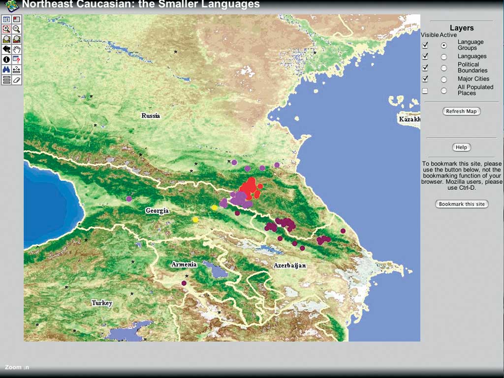
The map in Figure 3 is a snapshot of the map service. The smaller languages of the North Caucasian family are presented in the visible layer below. The map service lets the user display or hide the following layers:
The mapped languages are listed with their dialects. Each dialect is geocoded (i.e., associated with particular populated places). The language variation can be displayed on the map at three levels: higher-level language groups, individual languages, and dialect levels. Regardless of the level chosen, geographic details—such as topographic information, physical geography, and information about cities and villages—can be present at all times, or turned off. The typical Internet mapping service has functionality such as zooming, printing, and saving an image locally. The database can be queried using the Identification button, the Find function using string search, or the Query function (using SQL-based queries and Boolean searches). Querying needs further development to become more user friendly. Technical DetailsAt present, both the database and the service reside on a Windows XP computer. If additional funding becomes available, both will be moved to a server machine. The HTML viewer is used for an image service that runs on ArcMap ImageServer. This choice has both advantages and disadvantages as opposed to using ArcIMS ImageServer. The advantage is that the map configuration files can be set up in ArcMap, a much more functional mapping tool than ArcIMC Author. The disadavantage of this approach is that the table of contents and the legend are not easily manipulated. Also, the print function is unsatisfactory and was excluded from the application's tools. Point shapefiles generated from an Access database are used for the language layers. Other layers, point shapefiles for populated places and major cities, and polygon shapefiles for political boundaries as well as the rasters come from the GlobalGIS DVD. The raster files are not shown in the table of contents but are visible in the legend; it does not seem possible to amend this. ConclusionThe language map server, presented as a demo application, shows features that are completely absent from other language maps. These features include
Needless to say, the current application has not exhausted the possibilities offered by GIS technology. However, it shows the advantages of a nontraditional approach to language mapping with GIS. Pending funding, and with cooperation from other universities, the authors intend to expand the map service to cover other regions of the world. ReferenceDahl, �sten. 2005 (April). GISLI (GIS in Linguistics)—An Interactive Language Atlas. A research proposal submitted to the Swedish Research Council. Global GIS DVDsGlobal Mapping International, http://imf.geocortex.net/mapping/ worldmap/launch.html. Vinogradov, Viktor V. (ed.). 1967. Jazyki Narodov SSSR, v. 4. Moskva: Nauka. The Ethnologue: Languages of the World, http://www.ethnologue.com About the Author�sten Dahl is a professor in general linguistics at Stockholm University. One of his main areas of research is language typology (the comparative study of the structural properties of languages around the globe), in particular areal typology. This is the study of the geographic distribution of linguistic features and the forces that give rise to it. His engagement in language mapping and GIS in linguistics is a natural extension of this interest but may also have something to do with being exposed to maps from an early age by parents who were both geographers. He is a contributor to the World Atlas of Language Structures published by the Oxford University Press in 2005. He is also a co-editor of a planned volume on languages in the Swedish National Atlas. Ljuba Veselinova received her doctorate from the Department of Linguistics, Stockholm University in 2003. Her work with GIS systems is an extension of her main interests, language typology and database design, and is an expression of a long-held interest in geography and language. She is also a contributor to the World Atlas of Language Structures. She is currently working on a GIS project that deals with urban sociolinguistics and is planning to map the languages currently spoken in the metropolitan area of Detroit, Michigan. |