ArcUser Online
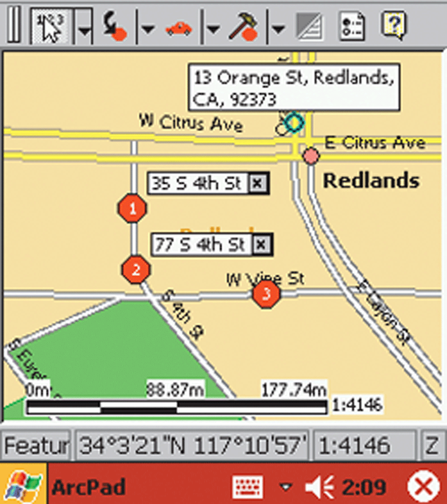
ArcPad simplifies field tasks for mobile GIS users. Supported on Windows platforms, 9.x, NT, 2000, and XP, in addition to Windows CE, ArcPad offers users advanced control and flexibility and ensures streamlined work flow with the support of real-time data collection that includes both spatial and attribute information manipulation. Custom forms simplify the interaction with the underlying GIS data and can be easily tailored to fit the needs of field users. The ArcPad StreetMap extension provides users with ready-to-use, quality data for the United States with predefined symbology, advanced address matching, geocoding, and routing capabilities. ArcPad StreetMap supports the Esri compressed data format used by the ArcGIS StreetMap extension and the ArcIMS Route Server. Streamlining Project PreparationArcPad StreetMap for the United States eliminates the time-consuming task of preparing the project-related layers that provide reference background information for a project. Although these layers may not participate in a business process, they are necessary for a project and must be clipped to the area of interest and appropriately symbolized. Time spent preparing these layers is time that could otherwise be allocated more productively. Moreover, extra datasets consume storage space that, despite ongoing improvements in handheld devices, continues to be very limited by GIS standards. ArcPad StreetMap supplies not only ready-to-use nationwide datasets with predefined, scale-dependent cartography but also tools that allow a specific area to be easily selected, clipped, and automatically transferred into a handheld device. Users can extract datasets with freely defined boundaries that can closely correspond to the project area, thus minimizing demands on device memory. Dynamap/Transportation from GDT is the first available dataset for ArcPad StreetMap. GDT offers complete nationwide datasets with high geometric accuracy including ramp structures, physical turn restrictions, turntables, and one-way streets. Geocoding and Reverse GeocodingIn addition to freely extractable datasets, ArcPad StreetMap includes robust, street-level geocoding capability. Address location involves providing either a complete street address with city and state names or latitude and longitude values. The best matched address or a house range is highlighted on the map. The limitations of handheld devices require an innovative approach that minimizes the amount of information typed using a Soft Input Panel (SIP) keyboard. A user can define a location on a map with a stylus, and ArcPad's reverse geocoding capability will return address information based on the map scale. At a small scale, the name of the city or street name is returned. At a large scale, a full street address is available. When ArcPad is receiving a GPS signal, reverse geocoding can be performed using coordinates supplied by the GPS receiver. Stops, Barriers, and Pushpins
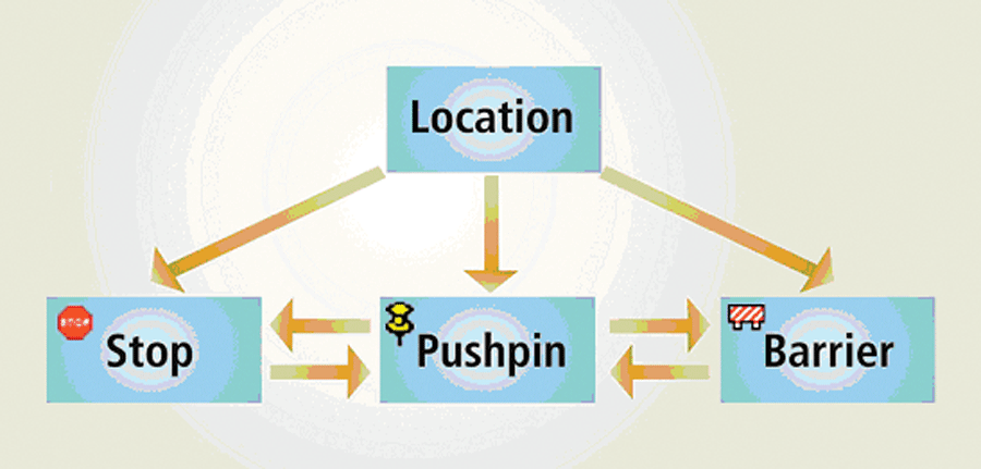
Once a location is geocoded and selected, it can be turned into a stop, a barrier, or a pushpin. A stop is a mandatory stopping point in the resulting route. A barrier is an avoidance point located on a street segment. A pushpin is a location that is not taken into account during route calculation but which may contain relevant information. A location's status as a stop, barrier, or route can be recast without repeating the geocoding process. Once all stops, barriers, and pushpins for a route are set, a route can be created. The fastest or shortest route solution uses point-to-point routing, which visits all stops along the route in the order defined by the user. Choosing an optimized route takes advantage of the Traveling Salesman Problem (TSP) solver, which retains start- and endpoints on the route without modification but reorders the intermediate stops. In either case, routes include turn-by-turn driving directions that can be displayed along with the map or displayed full screen with driving distance and travel time. Route segments are hyperlinked to the map. Geocoding and Routing FilesAlthough the ability to calculate routes in the field can be invaluable, sometimes generating on-the-fly stop points or barriers is impossible, unnecessary, or undesirable. Repeatedly geocoding the same information on a handheld device is cumbersome and inefficient. Stop, barrier, and route information may also need to be shared among users. Geocoding and Routing Files (GRF) (also known as locations files) can simplify operations and support information reuse. A GRF document is a properly formatted XML file that, at a minimum, contains information about geocoded locations and a list of stops, barriers, or pushpins. ArcPad generates a GRF document after a route is calculated and the map document is saved. It stores information related to the route such as its geometry, trip summary, and textual driving directions. Because GRF documents are maintained dynamically, adding or removing a stop, changing a stop's properties, or calculating a route triggers an automatic update of the GRF document. A GRF document can be shared with other users independently of the data. Sharing GRF documents is the easiest and quickest way to disseminate work orders related to location and routing information among field crews. Access to wireless mail (i.e., WIFI or wireless modems) lets dispatchers send e-mails with GRF attachments containing updated stop information to workers in the field. Although only one GRF can be used at a time, multiple GRF documents can be stored and reused. GRF documents are saved to the \My Documents folder. To load a different GRF document, simply open the StreetMap Options dialog box, tap the Locations File tab, and point to a different GRF document. Integrating ArcPad With Other ApplicationsAlthough GRF documents are currently generated and maintained only by the ArcPad StreetMap extension, a simple custom ArcMap script—available from the Esri Web site—allows users to select features and write the necessary information to a GRF document. After the GRF document is transferred to a handheld device, it can be opened in ArcPad StreetMap and used to find a route. This tool, called GRFGenerator, and its source code can be downloaded from the Esri ArcScripts Web site. ConclusionThe ArcPad StreetMap extension speeds up the data preparation process and enhances productivity by providing local, high-quality maps, geocoding, and routing within an area selected by the user. In addition, as the GRFGenerator script demonstrates, with a little custom code ArcPad StreetMap can be easily integrated with other ArcGIS applications. |