ArcNews Online
Fall 2010
[an error occurred while processing this directive]Saving the Ghost Cat of Central Asia
GIS Helps Revolutionize Snow Leopard Research and Conservation
Highlights
- Conservancy integrates camera imagery and data to count and track snow leopards.
- Using GIS helps improve population estimates by capturing data from many locations.
- The SLC uses ArcGIS to map snow leopard distribution.
Snow leopards, Panthera uncia, inhabit some of the highest, most rugged, snow-swept, least productive territories on the earth. They prefer the gorges, cliffs, and rocky outcrops above the tree line. Their numbers may be as low as 3,500, though they are found in a dozen countries in South and Central Asia, from Nepal to Russia—an area of more than half a million square miles. The Snow Leopard Conservancy (SLC) works to advance community-based stewardship of the snow leopard through education, research, and grassroots conservation action.
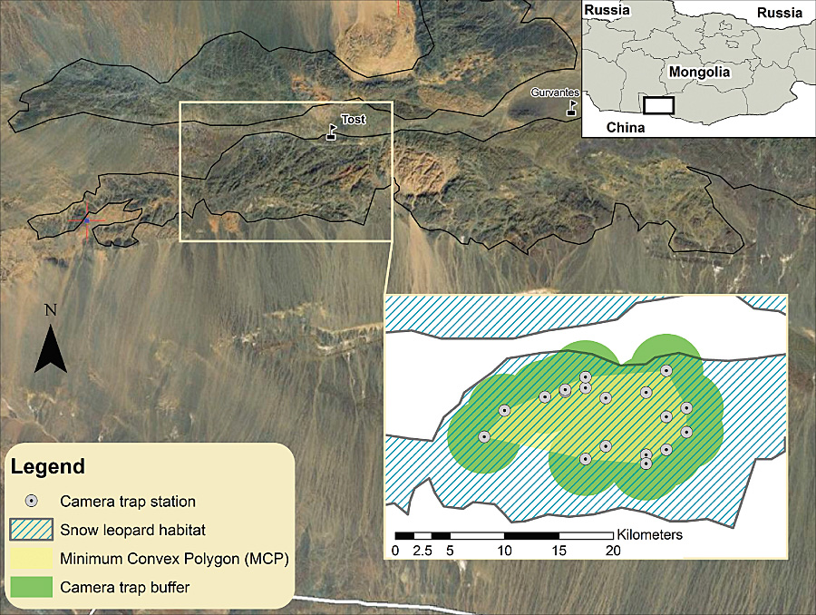
The Mongolian survey area's camera trap layout, buffer area, and regular activity centers.
Local communities live by agropastoralism. In seven range countries, more than half the people depend on animal husbandry, with over 40 percent living below poverty on average per capita incomes of US$250–$400 per year. While herders seldom see snow leopards, the cats occasionally kill their valuable livestock, so herders respond if they can by poisoning or trapping the cats.
Conserving this charismatic species presents many challenges, but SLC knows that by protecting the species, the conservancy also protects many plants and other animals of Asia's high mountain ecosystems. The introduction of remotely triggered cameras and sophisticated tools for extracting genetic material from scats has revolutionized SLC's ability to learn about snow leopards. SLC is now using GIS to enumerate snow leopards and map their distribution with far greater confidence. It uses GIS to improve population estimates by incorporating spatially explicit information on camera trap sites, habitat conditions, and photo-capture history of snow leopards.
Conserving snow leopards requires determining which places contain the best populations and which mountain ranges serve as critical corridors linking fragmented populations. The cats follow predictable routes along ridges or valley edges, where they scent mark overhanging rocks and leave scats or scrapes in prominent places. These signs are important communication methods for a species living an essentially solitary life; they also help biologists decide where best to place the remote, noninvasive camera traps.
The SLC survey was undertaken in May–July 2007 in the isolated desert massif of Tost Uul in the South Gobi province (100�35'E/43�10'N). The conservancy deployed 20 TrailMaster TM1550 active-infrared sensors for detecting the passage of any warm-blooded animal. These were connected to two cameras positioned to photograph either side of a passing snow leopard, with all traps set along characteristic travel paths next to clusters of scrapes or active scent rocks. SLC captured 120 snow leopard photographs during the 66-day survey, and it identified the individuals by their distinctive spotting pattern. From the number of captures and recaptures of each cat, it was able to estimate the total number present within the survey area.
With ArcGIS Desktop software and the ArcGIS Spatial Analyst extension (supplemented by third-party vendor tools), SLC mapped camera trap locations and snow leopard habitat (mountain areas) or nonhabitat (surrounding desert plains). To establish the extent of area trapped, SLC generated a buffer of fixed width around the trap array based on the mean maximum distance that snow leopards moved between successive captures. Then, using the computer program Capture (www.capture.com), SLC estimated the capture probability and population size of the leopards, which amounted to a density of 0.75 or 1.52 cats per 100 square kilometers (just over 38 square miles), depending on the buffer width applied. Although SLC photographed a female and her three cubs, it excluded the cubs from analysis because they avoid remote cameras and are not yet part of the breeding population.
Then, to make use of all available GIS information, SLC supplemented its analysis with the recently released, spatially explicit software package SPACECAP (cran.r-project.org/web/ packages/SPACECAP/index.html), which operates under R (Project for Statistical Computing, version 2.9.2). This software utilizes GIS information fully to implicitly exclude areas of nonhabitat and to better model variation among individuals in capture probability attributed to behavior or different use patterns. Drawing on Bayesian theory, it provides nonasymptotic inferences that are more appropriate for small samples, typical of most carnivore photo-capture studies.
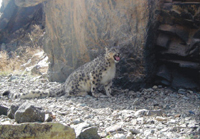
A snow leopard.
SLC turned to ArcGIS Desktop (ArcMap) to generate a set of regularly spaced points across the entire sample area for representing potential snow leopard activity centers needed by the algorithm implemented in SPACECAP. By examining graphic output, the conservancy was better able to determine how to improve trap coverage for future surveys in Tost Uul, along with designing more efficient photo-capture surveys for other areas. GIS can also be used to build other environmental covariates, such as landform ruggedness, vegetation, or slope steepness. Models that best explain the observed variation could then be integrated into future population surveys.
GIS provides a highly useful tool for immeasurably improving the robustness and precision of population estimates for long-term monitoring, especially when involving a rare species occupying remote, rugged, or diverse terrain. Combining sound field techniques with GIS spatial modeling enables researchers to generate the necessary data for informing program managers whether conservation interventions are working or not, as indicated by any increase or decrease in the number of snow leopards roaming the project area.
Equally important, the Snow Leopard Conservancy approaches such work collaboratively with local communities that coexist with snow leopards. Herders may collect scats for DNA analysis and monitor wildlife in their area. GIS-generated maps can be a meeting of Western and indigenous views of ecology, showing where livestock grazing areas are at the most risk of snow leopard depredation or where important habitat for ibex or blue sheep—the snow leopard's natural prey—might best be placed off limits for livestock. It's a win-win for everyone.
About the Authors
Rodney M. Jackson, Ph.D., is founder-director of the Snow Leopard Conservancy and an internationally recognized expert who has worked on snow leopards for over 30 years. He and his associates were the first to radio-collar snow leopards in Nepal in the early 1980s. Charleen Gavette is a GIS technician with the National Marine Fisheries Service, National Oceanic and Atmospheric Administration. She volunteers her time with the Snow Leopard Conservancy, helping incorporate snow leopard field data into state-of-the-art habitat modeling and three-dimensional landscape maps. Joyce Robinson, Snow Leopard Conservancy's office administrator, plays a key role in maintaining the organization's GIS database along with preparing maps for publication and dissemination.
More Information
For more information, contact Dr. Rodney Jackson, director, Snow Leopard Conservancy (tel.: 707-935-3851; e-mail: info@snowleopardconservancy.org; Web: www.SnowLeopard Conservancy.org).