Create and Share Redistricting Plans on the Web
Define Political Districts Quickly and Easily with Esri Redistricting
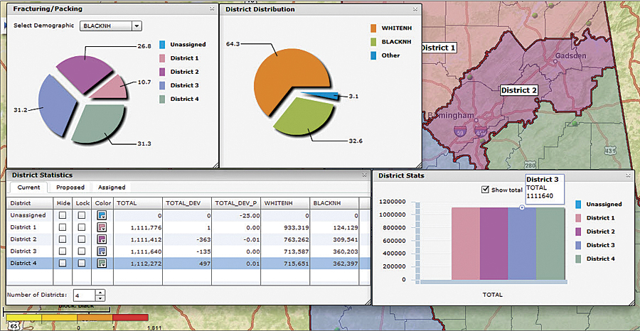
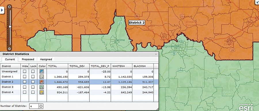
Redistricting plans must aim to equalize the population of districts as closely as possible. Esri Redistricting allows users to compare information such as the total population or race in several districts, as well as identify unassigned or fractured areas.
Government officials, advocacy groups, consultants, and citizens require sophisticated, easy-to-use tools to define their districts and, more importantly, understand the changes in population that have occurred during the last decade. Area population gains or losses will greatly impact legislative representation and funding for projects. To outline districts correctly and achieve proper representation and funding, officials must equalize each area's population as closely as possible and ensure that the new boundaries do not fracture a district. Providing additional transparency into this process has become increasingly important in 2011. Legislators and other entities must create redistricting plans; share them with selected groups for feedback and edits; allow submission and evaluation of alternatives; make the final output available to agencies, election officials, and the public; and be prepared to defend their analysis.
Esri Redistricting contains the tools and data that users need to fulfill all these requirements. Working via the web enables entities in numerous locations to quickly and easily collaborate and communicate on redistricting plans. Esri Redistricting is a Software as a Service (SaaS) solution hosted and managed by Esri that enables users to quickly begin creating redistricting plans.
Built on the powerful foundation of Esri's ArcGIS system, Esri Redistricting gives users a better perspective of their districts by including access to preprocessed Census 2000 data, 2010 TIGER files, and the soon-to-be-released Census 2010 Public Law 94-171 data in 2010 geography. The solution includes demographic maps; basemaps, such as streets, imagery, and topography; and a basemap created using the 2010 Census TIGER data. Users can also add data from previous censuses, along with proprietary information and existing legislative district boundaries, into maps for easy comparison and analysis. Security options allow them to establish user roles and lock or unlock district assignments to selected geographies. Editing tools provide undo and redo options for district assignment histories in previous versions of district plans, along with the ability to add comments and map notes to support collaboration within organizations.
This image illustrates tools available in Esri Redistricting. Step-by-step instructions enable users to begin work immediately in Esri Redistricting.
Esri Redistricting also allows users to incorporate the exact boundaries of a district; review plans by using plan comparison tools and reports; share and collaborate on plans within their organizations and with the public; add user-defined notes, shapes, and graphic image files; and use integrity checks to validate contiguity, dual assignments, district counts, null assignments, and population summary.
After plan areas have been mapped, users analyze population gains or losses by district; create, manage, and maintain the redistricting plan; effect public policy based on user results; and, if necessary, defend the plan to government agencies and elected officials. Users can also test district boundaries to see if they comply with federal and state redistricting guidelines, generate reports that summarize district statistics, share the results, and receive feedback from selected groups and/or the public.
For more information, visit esri.com/redistricting, where users can also sign up for a free 30-day trial. Esri can also host a custom version of Esri Redistricting or configure and install it at an on-site location. Both of these options include the ability to integrate an agency's custom data, such as polling points, historical voting statistics, and incumbents' residences. To discuss redistricting needs, interested parties should call 1-800-447-9778 or contact the Esri regional office in their area.
Related Podcasts
Redistricting: A Geographic Problem
Esri state government industry manager Richard Leadbeater provides a brief overview of redistricting and describes the essential role geospatial technology plays in it. Listen to the podcast. [12:00 | 11 MB]
Laying the Groundwork for Redistricting
Kim Brace, president of Election Data Services, an Esri business partner, explains how extensive databases are built to support redistricting. Having worked closely with state governments since the 1970s, Brace provides a historic perspective and a current snapshot of the sources and use of redistricting data, as well as its value after district lines are drawn. Listen to the podcast. [27:00 | 26 MB]
Deciphering the Latest Redistricting Trends
Tim Storey, Senior Fellow at the National Conference of State Legislatures, discusses new developments in the redistricting process across the nation. Listen to the podcast. [24:00 | 23 MB]