On Scale and Complexity and the Need for Spatial Analysis
By Carl Steinitz, Wiley Professor of Landscape Architecture and Planning
Emeritus, Graduate School of Design, Harvard University
 The best definition of design is that of Herbert Simon: "Everyone designs who devises courses of action aimed at changing existing situations into preferred ones." (Herbert Simon—The Sciences of the Artificial, 1968).
I come from a professional culture in which I began as an architecture student in a school of architecture; I then studied city and regional planning and urban design, and I have taught in a landscape architecture department and organized landscape planning studies for more than 40 years. Working at a territorial scale—in which algorithmic thinking and spatial analysis are essential—is, in my opinion and in my experience, very different from what is taught to and practiced by most designers. I want to discuss the implications of scale and complexity, two themes that differentiate design activities and their need for spatial analysis methods. In doing so, I will purposely sharpen contrasts that are really more subtle and frequently mixed.
Scale Matters
Scale matters, and Galileo was right. Many methods, many processes, many ideas that work at one scale don't work at another scale. My school has architects, landscape architects, urban planners, and designers. We have a studio-dominant culture, and there are different scales of problem. Most students' studio sequence starts small and gets larger and more complex but does not include the full range of scales. Problems dealing with the landscape include placing a building on a site; designing a garden; and designing an urban complex in a difficult ecology, or a large urban park. Most students who think about the landscape stop at what can still be considered "project scale." They stop at the scale where the assumption is that you have a client, a site, and a program and eventually something will be built. Relatively few students, the ones who work with me at the end of their studio sequence, think about regional scale urbanization and regional conservation.

Figure 1
There are many people in the world who think in the other direction, from large to small. Geographers, cultural historians, hydrologists, geologists, ecologists, political scientists, and even lawyers and bankers tend to see things and work from large to small, and they almost never get to the details so important to architects and landscape architects. The question is, what is the lens through which we should look at the problem? I'm interested in the larger scales. I have spent a long time working at the territorial scale, and sometimes I get to the project scale but stop before the details. I tend to think from larger to smaller. (See figure 1.)
The focus of design decision changes with scale. At large scale, you are dealing with strategy; at middle scale, you are dealing with tactics; and at small scale, you are really dealing with details, and here the details do matter. The wise school mixes scale-direction but must recognize that there are real differences at the extremes of these two scales. At the large scale, if you make a mistake or decide something badly, you have a very high risk of harmful impact. The concept of risk dominates working at this scale. You want to minimize it. Why? Because the landscape is big, it has lots of people, lots of money, lots of change, and the larger decisions are very important. The benefits can be great, but the risks are serious.
As you go to a smaller scale, the risk goes down: I don't care so much if my neighbor has a modern house or a baroque garden. What's the risk to me? However, I do care greatly if I don't have drinking water. That's a very important risk. The greater the risk, the greater the need for serious analysis, and this is much more a need as scale-related risk gets larger.
Minimizing social risk, economic risk, ecological risk, etc., makes a landscape plan essentially defensive. Here, the design processes emphasize allocation, deciding what goes where or where not. At a municipal or large project scale, it is more decentralized, with different professions, different neighborhoods, and different clients all coming together. At large project scale, the design emphasis is on organization, how different elements relate to each other. At small project scale, the emphasis is more on expression: what does it look like, what does it feel like? These are very different.
At large scale, you must have a high reliance on science, and you must have a much more complicated formal strategy. At the larger scale, the idea that you can make a simple design concept diagram and really see it on the ground is foolish; it doesn't work. At this scale, however, you must have much more public understanding, and this is not easy. At large scale, there is no single well-informed client. At small scale, there usually is. People normally understand their own house; they may understand their neighborhood. They usually don't understand their city, and they surely don't understand their regional problems. In a democracy, informing the public requires clarity and transparency in both assessment and presentation. There is necessarily a difference in roles between experts and the popular will in decision making.
As a result, at large scale, landscape decisions are made by experts and elected people and unelected people. Elected people are the people you vote for, your government. Unelected people are the heads of banks and development companies who make planning decisions. These larger decisions are not normally made by popular vote. However, at small scale, everybody makes decisions.
As the spatial scale gets smaller, you have more of a demand-based strategy. What I mean by that is that a client says, I want something! You happen to agree, and you do it. It is based on demand; it is based on the push of the market. At large scale, it is more supply based and defensive: you have to understand the landscape, you have to understand the cultural values, you have to establish priorities, and then you have to defend them.
At small scale, you can get famous for making new changes, while at large scale, you do not generally get famous for protecting old landscapes. These are very different. A good analogy is the first law of thermodynamics. Energy can be converted to light, or heat, or any combination. Energy, in our case, is the investment of cost, time, research, people, expertise, etc. Light means knowledge; heat means excitement. At large scale, there is usually little that is exciting relative to the newness sought and seen in the small scale.
There is another important complication related to scale. There are two fundamentally different ways to make a design. (I am purposely making this contrast, fully aware that the two ways are frequently combined.) The first way is anticipatory and deductive. You are sitting in the middle of the night, at your table, and you have an idea. And you see the future. You see the future, and then you have to figure out how to get there. Every designer has had this experience, likely many times. You have thought about the problem and you see the solution, and then you have to figure out how you get there, and you almost always fail. It's hard!
The other way is explorative and inductive. You basically put together a set of issues and choices—a scenario. A scenario is a set of assumptions and policies that guide you into the future. There are basically two ways to navigate this scenario chain. In the first and typical way for designers, one goes out as far as one can, and recycles back when confronted with a design problem. You decide to do this and this and this, etc. The second way is to simultaneously test several different scenario combinations and systematically compare them before proposing a solution. You realize that you could do this, this, or this; let's suppose I do this. I then can do this, this, or this; let's suppose I do this, this one, or maybe I should have done it this way.
And either way, you almost always fail, because a typical large plan might have a sequence of 20 to 50 important decisions. And if you can make 20 correct decisions in a row, you should be a gambler in Las Vegas. That's why you frequently say, I've done enough, I don't care what color the carpet is. It's normal. It is a function of scale, of the lens through which you assess the problem and its solution.
At small scale, the deductive method is absolutely appropriate. The history of architecture and the history of landscape architecture are full of examples. The idea—let's make a white garden, let's make a round building—these are appropriate inspirations. But at large scale, the inductive methods are better. Why? Because if you make the wrong decisions in the beginning, you have created the likelihood of a very high risk. Early, high-risk choices require the most serious assessment methods.
In making a design at large scale, you have four fundamental considerations. One of them is history. You must know the history of the place, and especially the history of the plans for the place. I have never in my life worked in a place that didn't already have past plans. And the people who made them were not stupid.
The next things are facts. Facts will not change in the life of your own plan and your own study. I might work toward 20 years or 30 years in the future, and the bedrock geology is not going to change (if it is not volcanic).
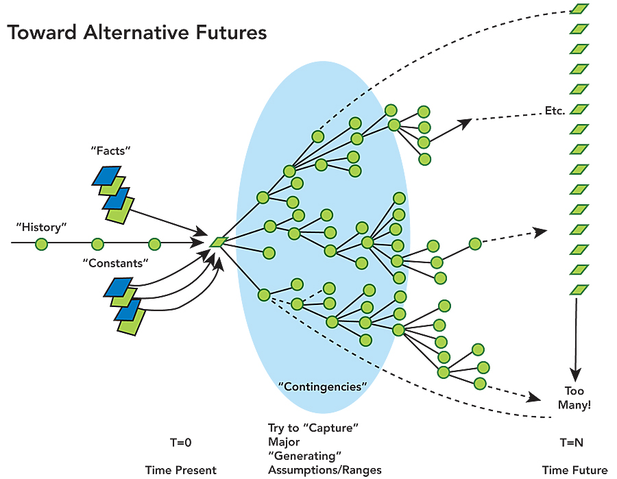
Figure 2
Then there are constants, which are the things that are going to happen during the course of your plan. You must find out about them, because if you don't, your plan will never be implemented.
And then there are the contingencies, the things that could happen, and here it is really important to capture the major generating assumptions and their alternative choices. You have to be able to say, either here, here, or here. The beginning assumptions in the scenario chain are the most important, because if you make the wrong first steps, you will end up wrong. If you make the right first steps, you still may end up wrong, but you have a better chance. (See figure 2.)
Complexity
My second theme, complexity, interacts with scale. It represents the level of complexity that the analytic methods underpinning any design must achieve, especially in its understanding of process models. I think there are six questions that must be asked in any design problem and at any scale. They are
- How should the state of the landscape be described in content, space, and time? This question is answered by representation models, the data upon which the study relies.
- How does the landscape operate? What are the functional and structural relationships among its elements? This question is answered by process models that provide information for the several assessments that are the content for the study.
- Is the current landscape working well? This question is answered by evaluation models, which are dependent on the cultural knowledge of the decision-making stakeholders.
- How might the landscape be altered, and by what policies and actions, where, and when? This question is answered by the change models that will be tested in the research. They are also data, as assumed for the future.
- What difference might the changes cause? This question is answered by impact models, which are information produced by the process models under changed conditions.
- How should the landscape be changed? This question is answered by decision models, which, like the evaluation models, are dependent on the cultural knowledge of the stakeholders and responsible decision makers.
Furthermore, I believe that there are eight levels of analytic complexity associated with process models. Each of the eight levels is organized to answer a cumulatively more complex set of questions. I think that the larger the scale and the consequent greater risk, the more the analytic methods should aim to achieve more complex levels. At smaller scales and with less risk, simpler analytic levels may suffice.
- Direct models ask, What is here? They are based on direct personal experience. If your feet are wet, don't build here.
- Thematic models add, Where and how much?
- Vertical models add, What else?
- Horizontal models add, What size and shape?
- Hierarchical models ask, What happens at different nested scales?
- Temporal models add, What if . . . and when?
- Adaptive models add, From what and where to what and where?
- Behavioral models add, From whom and where and when to whom and where and when?
Finally, the Bottom Line
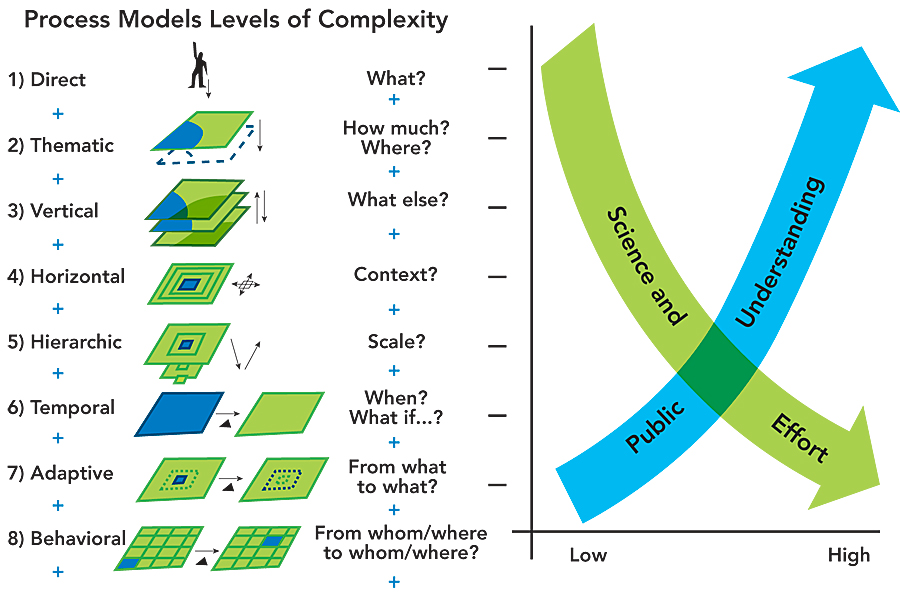
Figure 3
What are the spatial-analytic needs of designers? It all depends on scale and complexity. There cannot be one answer. At its simplest, and frequently at smaller scales, the direct personal experience of the designer may be sufficient, and without any formalized analysis. At the other, large-scale, extreme, it will frequently require a very complicated and costly effort, and yet it also may suffer from a lack of public understanding. Answering this dilemma and deciding on the appropriate methods and their level of complexity requires judgment and experience; there is no other way at this time. (See figure 3.)
However, there is a potentially important research study that can be derived from this situation. There are many models of processes, such as erosion, hydrology, forest succession, traffic, air pollution, noise, and visual preference. Comparing the efficiency and efficacy of process models across scales and levels of complexity might result in a better understanding of which combinations are the most appropriate fit for any design problem. This comparative research, and the resultant ability to categorize the applicability of the many analytic models that already exist, would be a significant step toward the theme of this article. It would certainly help the very broad-ranging community of designers. (See figure 4.)
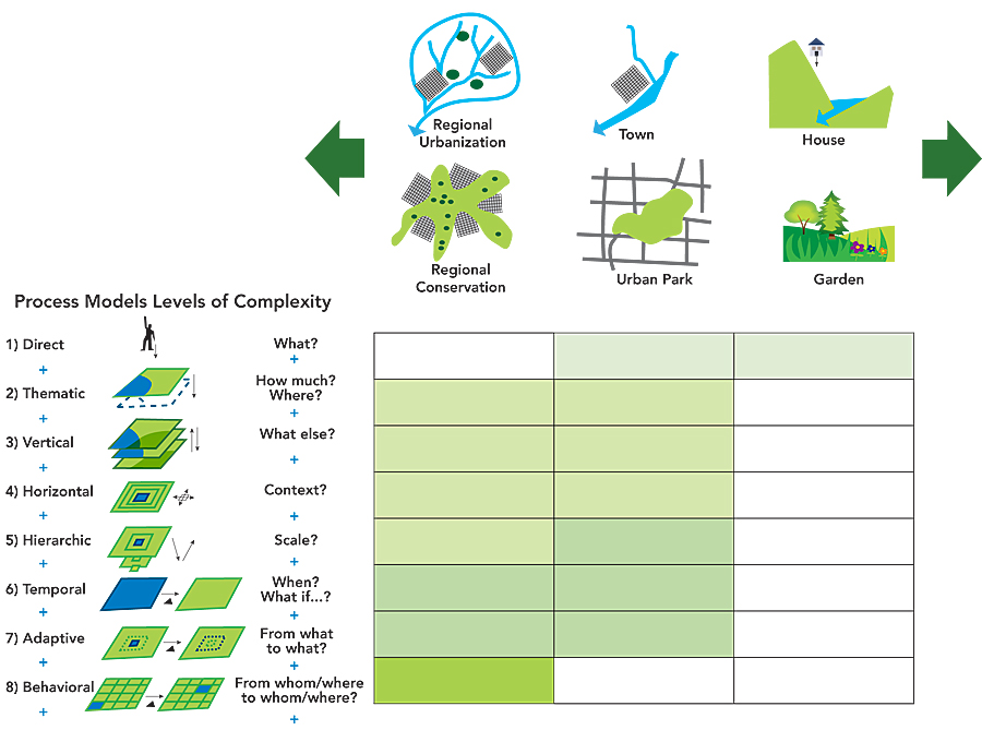
Figure 4
About the Author
Carl Steinitz is Alexander and Victoria Wiley Professor of Landscape Architecture and Planning, Emeritus, at Harvard University Graduate School of Design and Honorary Professor at the Centre for Advanced Spatial Analysis, University College London.
He began his affiliation with the Harvard Graduate School of Design as a research associate in the Laboratory for Computer Graphics and Spatial Analysis in 1966. He has held the position of Professor of Landscape Architecture and Planning at the Graduate School of Design since 1973.
Professor Steinitz has devoted much of his academic and professional career to improving methods to analyze large land areas and make design decisions about conservation and development. In 1984, the Council of Educators in Landscape Architecture (CELA) presented Professor Steinitz with the Outstanding Educator Award for his "extraordinary contribution to environmental design education" and for his "pioneering exploration in the use of computer technology in landscape planning, especially in the areas of resource management and visual impact assessment." In 1996 he received the annual Outstanding Practitioner Award from the International Society of Landscape Ecology (USA). In 2002, he was honored as one of Harvard University's outstanding teachers. Professor Steinitz is principal author of Alternative Futures for Changing Landscapes, Island Press, 2003. He is presently writing a book for Esri Press.
For more information, contact Carl Steinitz (e-mail: steinitz@gsd.harvard.edu). This article was adapted from a presentation given at the Santa Barbara, California, Specialist Meeting on Spatial Concepts in GIS and Design, December 15–16, 2008.