Scaling Up Classroom Maps
"Geo Learning"
![]() A column by Daniel C. Edelson,
A column by Daniel C. Edelson,
Vice President for Education, National Geographic Society
 Usually, when you talk about the scale of a map, you're talking about the ratio of distances on the map to distances in the real world. These days, however, when educators working with National Geographic maps talk about scale, they may be talking about how big the map is. For example, a teacher may have her students working on a map at the "scale" of a tabletop, a large wall, or even a basketball court.
So what's going on with all these big maps? Well, we've learned that kids find large maps to be magnetic. And not just young kids. Teens and adults find large maps irresistible as well.

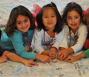
Two Middlebury, Vermont, third graders explore the Atlantic coast of South America (photo: Dan Beaupre).
Imagine walking into your school gym and finding half of the floor covered in a glorious, full-color, National Geographic map of Asia. If your school is one of those that has signed up for a visit from one of National Geographic's Giant Traveling Maps, you could.
Most people find they can't just look at these maps. They must walk on them. They count how many steps it takes to get from Beijing to Moscow. They lie down to see if they can reach from the southern tip of India to the northern tip. They find the maps amusing, just like the oversized cereal boxes at Costco.
Frankly, people find the scale of these maps fascinating. And educational. Unlike regular-sized maps, you can see lots of detail and a large portion of the earth's surface at the same time. Similarly, you don't shift your eyes or turn the page if you want to look at a different location. You move your whole body, like you do in the real world. These maps allow people to interact with a map kinesthetically, experiencing scale and direction as physical sensation.
Students at Alta Vista Elementary School in Los Altos, California, take a well-earned break after traveling from Florida to Alaska on the Giant Traveling Map of North America (photo: Scott Schilling).
Now imagine taking 136 sheets of 8.5" x 11" paper and putting them together to form a mosaic map of the world that is 17 sheets wide and 8 sheets tall. If you download one of the free NatGeo MapMaker Kits, you could. These "megamaps" are only 10 feet wide and 7 feet tall, but they still take several strides to walk across. And, since they are made of regular printer paper, you can draw or paste things on them. You can even cut them up.
These "scaled-up" maps have great educational potential. They break down the usual barriers between people and maps. They draw people in, and they encourage them to interact.
Both the Giant Traveling Maps and the MapMaker Kits are packaged with a variety of hands-on (literally) activities. When a Giant Traveling Map arrives at your school, it comes with a trunk full of materials that transform it into a giant game board, including giant dice, traffic cones, plastic building blocks, and beanbags. The MapMaker Kits are designed as basemaps for students to draw, glue, or overlay information on.
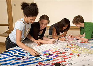
Students use markers to illustrate data on National Geographic Education's NatGeo MapMaker Kits (photo: Mark Thiessen, NGS).
In fact, some of the most engaging activities for these oversized maps are essentially low-tech versions of geospatial analyses. Have you ever represented a buffer with a hula hoop? Measured a linear distance in units of arm spans? In a classroom down the street, students may be symbolizing data by pasting construction paper circles of differing sizes and colors on a map. Or they may be creating contour maps with yarn and delineating watershed boundaries with a crayon.
Some of the best educational ideas are just slight twists on conventional practice. What we've discovered is that blowing up maps to unusual sizes is one of those ideas.
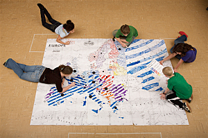
Students record data about tourist impact on different countries in Europe using National Geographic Education's NatGeo MapMaker Kits (photo: Mark Thiessen, NGS).
For more information about the Giant Traveling Maps, visit www.nationalgeographic.com/ giantmaps. For more information on the NatGeo MapMaker Kits, visit www.natgeoed.org/mapping. Follow Daniel Edelson on Twitter @NatGeoEdelson.