ArcUser
Winter 2012 Edition
Dealing with Rapid Growth and Program Compliance
Determining which properties need elevation certificates
By Christopher Wanamaker, Pinal County Flood Control District
This article as a PDF.
From 2000 to 2010, the population of Pinal County, Arizona, grew from 179,727 to 375,770. During this period of extreme growth, the county's resources were taxed trying to keep up with new development.

The final dataset that identified which properties needed elevation certificates required processing five data sources in four steps.
This was especially true for the county's floodplain management program. In 2008, the Pinal County Flood Control District took over management of this program and began employing Esri's ArcGIS software to ensure that every property located within a floodplain had a copy of the Federal Emergency Management Agency's (FEMA) mandatory elevation certificate.
To bring the county's floodplain management program into compliance with the National Flood Insurance Program's guidelines, staff needed to quickly figure out which properties had elevation certificates and which properties needed them.
Staff began manually reviewing and entering the existing elevation certificates into a comprehensive Microsoft Excel spreadsheet. Meanwhile, flood control district's engineers were hard at work developing a complete dataset of all the properties that required elevation certificates. However, because the county's maps had recently been revised, this task wasn't a simple one.
Development of the property dataset began by joining the county tax assessor's parcel database (maintained in Microsoft Access) with property boundary data in ArcGIS. Next, all vacant parcels, parcels with buildings constructed before August 1983 (when Pinal County became a participant in the National Flood Insurance Program), and parcels located outside the flood control district's jurisdiction were removed. Finally, an additional field was added to the data to categorize the properties by building construction year. This field was used to separate the properties into two groups based on whether structures were built before or after the floodplain maps were revised in December 2007.
In the next step, Pinal County's older (1983) and newer (2007) floodplain maps were examined. Significant portions of Pinal County had been added to the floodplain after the 2007 map revision. There were hundreds of existing homes that did not necessarily require an elevation certificate for the county's purposes even though they were now shown as being located in a floodplain. When the two sets of floodplain maps were combined and processed, the result was a comprehensive data layer that clearly showed where newly designated and existing floodplains were located.
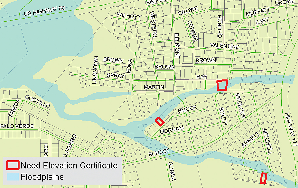
This map shows the results of the completed analysis. Parcels needing new elevation certificates are highlighted in red.
In the third step of the analysis, the modified property and floodplains datasets were combined. The data was further refined by identifying and removing duplicate parcel numbers using a simple Visual Basic for Applications (VBA) script. Parcels located in the new floodplain that had structures constructed prior to December 2007 were also removed from the list. The resultant comprehensive dataset showed Pinal County staff that nearly 1,845 properties needed elevation certificates.
In the final step, the original Excel spreadsheet containing the existing elevation certificate information was joined to the final parcel dataset in ArcGIS for Desktop Basic. The result gave a clear picture of which properties had elevation certificates and which needed new ones. Based on this GIS analysis, Pinal County was able to develop an accurate budget and reasonable time frame for obtaining elevation certificates for those 457 properties.
The most challenging part of this project was figuring out an efficient way for developing a comprehensive list of properties requiring new elevation certificates. The dataset was so large and there were so many variables involved in completing this analysis that it could not have been done without ArcGIS.
For more information about this project, contact Christopher Wanamaker, Pinal County Flood Control District engineer, Arizona, at 520-866-6010 or Christopher.Wanamaker@PinalCountyAZ.gov.