ArcUser
Winter 2012 Edition
Modeling Walkability
Automating analysis so it is easily repeated
By Arjun Rattan, Anthony Campese, and Chris Eden, Regional Municipality of Halton, Ontario, Canada
This article as a PDF.
The health and planning departments in one of Canada's regions have joined forces to analyze just how accessible stores and services in neighborhoods are by foot or bike. Walkable neighborhoods can also reduce pollution from greenhouse gas emissions generated by vehicles.
The GIS Services section within Halton Region's Planning Services Division, in collaboration with Halton Region's Health Department in Ontario, Canada, recently completed an analysis workflow to determine the walkability of the region. [The region covers more than 232,000 acres, including a 25-kilometer frontage onto Lake Ontario, and has an approximate population of 467,200.]
ArcGIS 9.3.1 geocoding tools, along with the Network Analyst 9.3 extension, were key technologies used to determine Halton's walkable areas. ArcGIS ModelBuilder 9.3 enabled automation of the workflow, making the process both quick and easily repeated without requiring extensive technical GIS knowledge.
What Is Walkability?
Walkability is a measure of the effectiveness of community design in promoting walking and bicycling as alternatives to driving cars to reach shopping, schools, and other common destinations. The Centers for Disease Control and Prevention (CDC), the World Health Organization (WHO), and other health organizations advocate increasing the walkability of communities to promote fitness, combat obesity, and enhance sustainability.
Quantifying Walkability
For this project, three factors—density, diversity, and design—were calculated for use in measuring walkability. Density was quantified as residential population density and job density. Diversity was quantified as the percentage of residents within walking distance of defined diverse uses (DUs) that provide a measure of mixed-used development. Design was quantified as trail availability per 1,000 residents, bicycle path availability per 100 residents, and the number of intersections per square kilometer.
These factors were equally important when assessing the walkability of an area. From a GIS standpoint, calculations relating to density and diversity were relatively simple and enabled by ArcGIS technology.


These screen captures illustrate the difference between service areas for a post office created using Euclidean distance buffering (left) and street network buffering (right). The residential parcels northwest of post offices are not classified as walkable when Network Analyst is used to create the buffer. In this realistic scenario, a water body impedes walkability of these post office locations. Note: Sample data used to protect privacy of residents.
Five analysis areas (AAs) in the Halton Region were specified for the project:
- Dissemination areas (small areas composed of one or more neighboring blocks with a population of 400 to 700 persons)
- Census tracts
- Neighborhoods
- Municipalities
- The Halton Region as a whole
Dissemination areas were the smallest AAs because they showed an acceptable level of detail while still allowing comparisons to census data.
Halton Region's Health Department defined three parameters needed to determine and quantify diversity:
- AAs for which walkability needs to be determined
- DUs needed by residents
- The distances to/from DUs (in meters) considered walkable distances
Table 1 lists the DUs used for the project, along with the walkable distance criteria to the DU location. These distances represent 5- and 10-minute walking times (except for elementary schools).
| Diverse Use (DU) | Walking Distance Criteria (i.e., distance from residence to DU) |
|---|---|
| Transit stops | ≤ 400 meters |
| Grocery stores | ≤ 800 meters |
| Fresh food places | ≤ 800 meters |
| Convenience stores | ≤ 400 meters |
| Elementary schools | ≤ 1,500 meters |
Gathering and Preparing Data for Analysis
Datasets required to conduct the walkability analysis were AAs as polygons, streets as lines, residential locations with population information as polygons and points, and DU locations as points. The AAs and streets layers were available from the region's spatial database. Residence locations were extracted from the Ontario Municipal Property Assessment Corporation (MPAC) parcel layer. The MPAC parcel, street, census tract, municipality, and region layers were current as of 2011. The dissemination areas file was from 2006, and the neighborhoods file was from 2009.
The MPAC parcel property code (PROP_CODE) and structure code (STRUCTURE_) fields were used to identify residential parcels. These parcels were exported and formed the residential parcel location polygon layer. A persons per unit (PPU) attribute field, added to the residential parcel layer, described the average number of people associated with a particular residential dwelling type (e.g., PPU for single-family dwelling units was 3.08).
PPU values were calculated by Halton Region's Planning Services. For parcels with multiple units, parcel roll numbers were used with the MPAC Municipal Connect online database to verify the number of residential units on a parcel. The PPU field was multiplied by the number of units on the parcel to get the total population for the parcel. This value, stored in the UNIT_POP field, described the total population of a residential parcel. Calculating population using the PPU field enabled estimating current population on a per parcel basis. Moreover, census population information was outdated; the most recent census information was 2006.
A copy of the residential parcels polygon layer was exported as a point layer using the Feature To Point tool (ArcToolbox > Data Management > Features). Both residential parcel polygon and point layers were used later in the analysis workflow.
Geocoding DU Addresses
Of the DU data items listed in Table 1, only transit stops were available as a shapefile. Most DU location addresses, available from a Microsoft Access database, were gathered as part of the 2010 Halton Region Places of Employment Survey. The required DUs were identified (and exported as Microsoft Excel tables) by North American Industry Classification System (NAICS) code field. (NAICS identifies business and service types.) Addresses for postal service locations (not available from the employment survey) were gathered from the Canada Post website. Education Services addresses were gathered by contacting school boards in the region, in addition to the addresses of private and public higher education institutions within Halton. Similarly, Fresh Food Places address data was gathered by contacting local organic and fresh food stores.
Having the DU locations available as a point shapefile was critical to the walkability analysis workflow. ArcGIS 9.3.1's geocoding tools converted DU addresses into spatial points. A new geocoding address locator was created using an address point shapefile. The Zone field in the address locator enabled identification of street addresses with the same street name that are located in different municipalities (for example, 543 King Street exists in both Oakville and Halton Hills). A high minimum match score minimized the chance of a DU address being matched to the wrong address point.
The automated geocoding process achieved a success rate of more than 90 percent for all DU addresses geocoded. The Pick Address From Map tool in the Geocoding Review/Rematch Addresses function helped bring the geocoding match rate up to 100 percent. This tool was used to pick points on the map that were verified as locations of unmatched addresses.
Determining Diversity
Having gathered and prepared the data required for analysis, the next steps involved determining the percentage of residents who live a walkable distance from DUs. Analysis involved repeating workflow steps for different input parameters such as AAs and DUs. ModelBuilder 9.3 was used to automate this process. The workflow steps for this analysis included
- Calculate and assign the total residential population for each AA.
- Calculate a service area (SA) for a DU.
- Select residential parcels that intersect the SA for each DU.
- Calculate the percentage of residents in each AA with walkable access to a specified DU.
- Classify and visualize walkability.
Calculate and Assign the Total Residential Population for Each AA
The total residential population was calculated and assigned as the sum of the UNIT_POP field for all residential parcel points that were within the specified AA. In assigning total residential population to an AA, residential parcel points were used instead of residential parcels to prevent parcels that fall on the border of multiple AAs from being included in the total population calculation of multiple AAs.
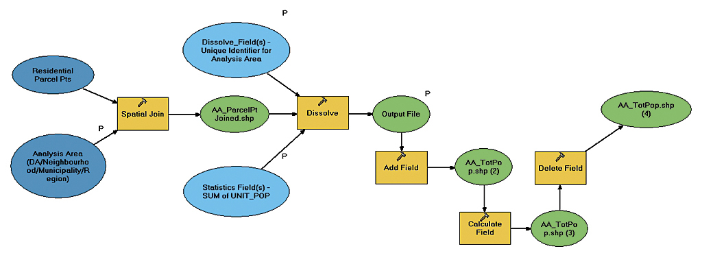
This model assigns total residential population to an analysis area.
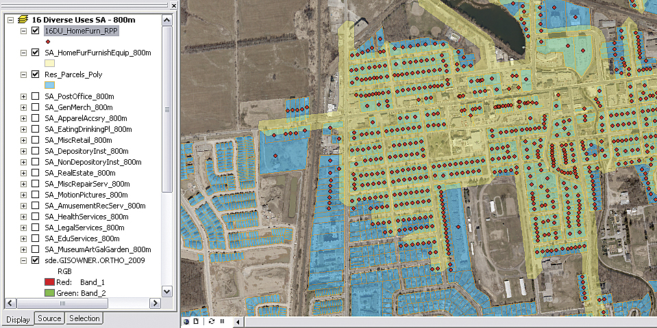
Intersecting residential parcel points for Home, Furniture, Furnishings, and Equipment Stores service areas
Calculate Service Area for a DU
The SA for a DU was based on the walking distance criteria in Table 1 and represented all the locations that have walkable access to the specified DU. Using straight-line Euclidean distance to create a buffer around the DU was initially considered as a solution to create the SAs. However, this method wasn't realistic from a walkability standpoint because it didn't account for physical barriers such as water bodies, railway lines, buildings, and other obstructions.
Network Analyst 9.3 tools were used in ModelBuilder to design an algorithm that calculated the SA for a DU, using the Halton street network. This SA model represented a more realistic visualization of walkable access to a DU by using the street network rather than Euclidean distance.
In ArcCatalog, the Halton streets layer (Streets_Ctrline.shp) was used to create a new network dataset for network analysis. The distance in meters was the only cost associated with the network dataset, because no network analysis involving travel time was required. After the SA is calculated, it is exported as a polygon layer. The Select Facility parameter specifies the DU for which SA is to be calculated. Created SA polygons were merged and trimmed to 30 meters. This distance was determined to be the best distance for ensuring that only residential parcels identified as walkable to the DU were selected.
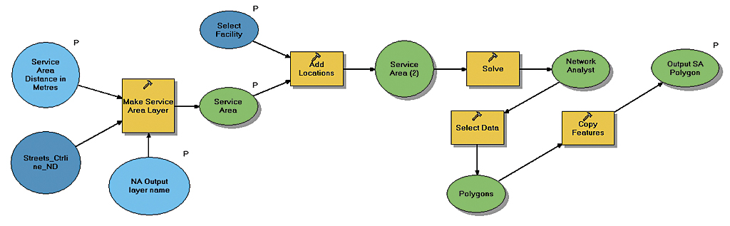
Model for calculating service areas for diverse uses and exporting it as a polygon
Select Residential Parcels That Intersect the SA for Each DU
This step involved selecting residential parcels within walkable distance from a specific DU. The selected residential parcels were converted to residential parcel points to prevent walkable parcels that fall on AA borders from being included in multiple AAs in the next step.
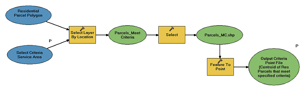
Model for selecting residential parcels that are in walking distance to a specified diverse use
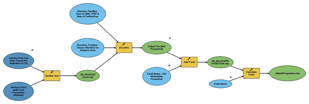
Calculate the Percentage of Residents in Each AA with Walkable Access to Specified DU
Listing 1 illustrates how the percentage of residents with walkable access to a specific DU is calculated. This step also assigns the calculated proportion to the AA shapefile.
The Visual Basic for Applications (VBA) code in Listing 1 was used in the Calculate Field tool to calculate the proportion of residents (PR16DUPost field) that live a walkable distance from a post office. A conditional statement is required to prevent illegal division by 0 (in the case that total residential population of an AA is zero).
A model for calculating the total residential population of an analysis area
Dim x as Double

If ([MAX_TotRes] > 0) Then

  x = [SUM_UNIT_P] / [MAX_TotRes] * 100

Else

  X = 0

End If
Listing 1: Percentage of population in walkable residencesClassify and Visualize Walkability
The results of the walkability analysis were used to construct a database that contained walkability calculations for density, diversity, and design for each dissemination area. This database was used to summarize results for census tracts, neighborhoods, municipalities, and the Halton Region. Choropleth map layouts for various DUs for different AAs were produced to visualize walkability to DUs. The maps displayed AAs classified by the walkability percentage field. The areas in red represent the areas with low walkability to elementary schools. A separate walkability map for each DU enables the planning process to focus on services that are most in need, for a given AA.
Project Repeatability
The walkability project took approximately three months to complete. A key goal for this project was repeatability. The analysis workflow should easily be repeated with updated data and criteria. Creating a custom ArcGIS toolbox that houses custom ModelBuilder models enables the project to be repeated in significantly shorter time periods by users who don't have extensive technical GIS knowledge.
The entire walkability analysis workflow for the diversity factor (excluding data gathering/preparation) can be repeated by running the four models in the custom Walkability Tools toolbox developed for this project. Running the models in batch mode lets models use multiple inputs simultaneously and saves both time and effort.
Conclusion
An area's walkability is not a single quantifiable measurement. Walkability, in this study, was measured using calculations related to an area's density, diversity, and design. These three factors provide valuable information for assessing an area's walkability. Examining the database and walkability maps of the various DUs for different AAs provides a context for determining whether an area needs more social marketing to encourage walking (if walkability is high) or better design to increase access (if walkability is low). ArcGIS 9.3.1 geocoding tools, ModelBuilder 9.3, and the Network Analyst 9.3 extension are key GIS technologies that make a realistic determination and visualization of walkability feasiblity. ModelBuilder, in particular, enables project repeatability while minimizing project completion timelines.
About the Authors
Arjun Rattan is a GIS planning assistant at Halton Region's Planning Services Division. Before joining Halton, he earned a bachelor's degree in urban studies and art history from the University of Toronto and completed a two-year diploma in geomatics from Sir Sandford Fleming College in Lindsay, Ontario.
Anthony Campese is a GIS analyst with the Legislative & Planning Services Department who is responsible for maintaining the GIS functions in the Planning Services Division and acts as a liaison with IT staff. He has worked in the public sector for 12 years. He is also an instructor in real property administration and public administration—municipal programs at Seneca College. He is a graduate of Fleming College's GIS Applications Specialist program and holds a degree in urban geography from Brock University.
Chris Eden is a GIS data technician with the Legislative & Planning Services Department. He is responsible for maintaining the planning data and field collection of data. Eden has been working in the public sector for eight years. He is a graduate of Ryerson University's Geographic Analysis program.