ArcUser
Fall 2011 Edition
Daunting Task Gets Easier
Geotagged photos aid real property inventory
By Kevin P. Corbley
This article as a PDF.
An efficient and easy-to-use photo-mapping inventory process developed by the US Army Corps of Engineers (USACE) is being used to inventory real property assets and output ArcGIS feature layers that map geotagged photos and contain attributes.
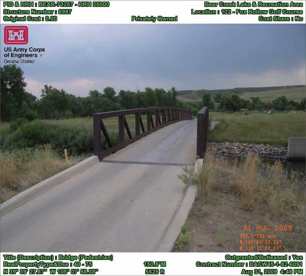
Attributes, such as hand receipt number, location, and asset type, are embedded in the photo. Geotagged photos can be exported from the photo-mapping software as an ArcGIS map layer containing icons placed at the precise geographic locations of photographed features.
The Chief Financial Officers Act of 1990 (CFO Act) sought to reduce government waste by improving the efficiency of financial management and accounting practices at US federal agencies. Among its many mandates, the act directs government departments to conduct regular inventories of their assets worldwide—this includes audits to assess and document real estate assets.
Under the act, real property audits apply to vacant parcels as well as improved properties. Audit guidelines require every government agency to inventory its properties and determine where they are located and assess how much they are worth. Documentation must include photographs of any buildings and structures and their geographic coordinates.
The inventory mandate was challenging for all federal agencies, but particularly daunting for the USACE, which owns, operates, and manages thousands of civilian and military properties located around the world. Primarily responsible for major civilian design, construction, and public works projects within the United States, the Corps also maintains land records for 250 military facilities on behalf of the US Army and US Air Force.
"[USACE] real property runs the gamut from a radio tower and building on a piece of land to a major dam complex with 1,200 individual items," said Roger Miller, the real property administrator for the Corps' Omaha (Nebraska) District.
The Corps is divided into 45 districts worldwide, delineated either by watershed (for civilian projects) or political boundaries (for military support activities). The Omaha District has more than 6,000 buildings or structures in management areas covering eight states. This district became the first to develop a highly efficient inventory process that involves geotagging and photo mapping to create a real estate layer in ArcGIS.
Until recently, the Corps primarily used CAD for mapping projects. However, many divisions in the agency are now adopting ArcGIS for this purpose. The Corps' Northwestern Division, which includes the Omaha District, is building a division-wide GIS containing layers for real property, engineering, operations, and project management. Once completed, this web application will make details of properties, facilities, and projects available to anyone in the Corps via a web browser.
Finding a Solution
Miller recalled the difficulties he encountered during his first assignment to perform an inventory of a project site. He was given a handheld GPS receiver and digital camera. At each feature, he snapped photos from one or more perspectives and then jotted down the latitude-longitude coordinates from the GPS screen.
"I came back from that not too happy with how long it took," said Miller.
And if the time spent in the field seemed excessive, even more time was required back at the office to correctly correlate digital photos with property locations. Once the handwritten notes were correlated, it was a manually intensive process to rename and post the photos to their correct locations. To get an aerial view of a specific area required looking up each one using the resources available on the Internet.
Miller searched the web looking for an integrated system to streamline the asset inventory task. He eventually found Ricoh cameras (models 500SE and G700SE) with built-in GPS, compass, and attribute notation capabilities. He also discovered software that drastically reduced the correlation and mapping work back at the office. The Ricoh camera was offered as a bundled solution by Esri partner GeoSpatial Experts of Thornton, Colorado, developer of GPS-Photo Link photo-mapping software.
This software automatically correlates photos with their geographic coordinates and stamps the location and time, along with any other user-defined attribute data, as watermarks on each photo. GPS-Photo Link then outputs the photos to an annotated map layer in ArcGIS.

Roger Miller, the real property administrator for the Corps' Omaha (Nebraska) District
"It was all off-the-shelf technology that anybody could use," said Miller. "That's how I came up with the process that I'm currently using."
Putting Photo Mapping to Work
Typically, Miller travels around the project site by foot or car. Since all projects in the Omaha District have been inventoried at least once, he carries a printed list of items that must be visited and photographed as he looks for new assets that have been built since the previous visit. In the interests of accuracy and consistency, Miller has devised procedures for how each asset will be photographed. Large buildings, for example, are photographed from each side, while a small picnic table pad requires only one photo.
The Ricoh G700SE and 500SE were designed for use with GIS. Miller takes full advantage of their capabilities. As he photographs each item, the camera's GPS records the location. When positional accuracy is critical, he stands immediately next to the feature, holds a GPS lock button on the camera, and then moves away from the feature to snap the photo so the unit records the location of the item rather than the location of the camera when the photo was taken.
In some situations, such as a large dam structure, properties are not accessible by foot. In those cases, he links a TruPulse laser range finder to the camera via wireless Bluetooth connection. The laser determines the distance to the feature, and the software combines that distance information with the bearing and position information from the camera to calculate an offset position.
The Ricoh G700SE and 500SE act as data collection devices as well as cameras and GPS units. Each USACE asset is identified by a property identification (PID) number. While on-site, Miller selects values from the drop-down menus—created on a PC and transferred to the camera—to collect attributes for each item. These attributes are embedded in the photo. The attributes stored for each item are PID number, hand receipt number, location, asset type, structure number, description, original cost (if available), outgranted/outleased status, contract number, whether it is a cost share item, and the real property type and use codes.
Up to 100 notes or memos can be stored in the camera as attributes along with the GPS coordinates, which are linked permanently to each photo. Some assets have bar code stickers containing PID numbers that the Ricoh cameras can scan and automatically store with each picture.
Because thousands of photos may be taken for a single project during an inventory, Miller first organizes the pictures by location. He uses the basic editing software provided with the camera to add, delete, or update information. He then uploads the photos and attributes to the GPS-Photo Link software on a standard personal computer. The software can correlate hundreds of photos with GPS point locations and attributes in just a few minutes.
He then decides which attributes (e.g., coordinates, acquisition date, PID, assessed value) will be stamped with a watermark on each photo. Back in his Omaha office, Miller outputs the geotagged photos from the photo-mapping software as an ArcGIS map layer containing icons placed at the precise geographic locations of photographed features. Users click icons to view photos and related attribute information.
With photo-mapping software, Miller can output photos in a variety of other formats including PDFs, HTML reports, spreadsheets, or Microsoft Word documents.
Creating a Real Property GIS
By late 2011, Miller expects to have ArcGIS running on his laptop in the field. Although he can perform all photo and attribute editing in GPS-Photo Link, he currently has to wait until returning to his office to edit the GIS output layer in ArcGIS. Soon he will generate the ArcGIS layer in the field from his laptop and upload it to the division website.
The move away from CAD to GIS for storing information relating to real estate and other facilities will offer significant benefits across the Corps, according to Jesse Otterson, a cartographer in the Omaha District.
"It's a dataset that becomes helpful not just to our real estate division but also to people involved in operations and maintenance," he said. It helps people understand the buildings they maintain.
Miller's inventory process is so efficient and easy to use that he has been asked to teach it to other real estate specialists throughout the Corps and in other government agencies. The Corps is currently performing its real property inventories in three-year cycles. Because it was the first government agency to complete an audit under the CFO Act, the Corps' procedures are being emulated by other federal offices.
About the Author
Kevin Corbley is a communications consultant in the geospatial industry. He can be reached at www.corbleycommunications.com.