ArcUser Online
GIS Bookshelf
This article as a PDF.
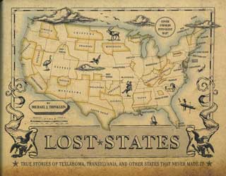
Lost States: True Stories of Texlahoma, Transylvania, and Other States That Never Made It
by Michael J. Trinklein
Michael Trinklein, known for PBS documentaries (Pioneers of Television, The Gold Rush, and The Oregon Trail), takes an irreverent look at the states that could have been. Many statehood movements involved carving out sections of existing states. A remarkable number of these schemes involved Texas (Texlahoma, Adelsverein, Comancheria, Jacinto, South Texas, and North Texas). Others, like the proponents of Charolotina, took the opposite tack and suggested subsuming several states into one giant state. Many statehood campaigns were organized around getting something—tourists or highways—or getting away from something else, like taxes. Surprisingly, some statehood movements advocated adding new states—like Cuba and Guyana—that were independent countries. Some lost states were the forgotten remnants of other states. In the 1840s, No Man's Land was a forgotten sliver of northern Texas that lacked an affiliation with any state or territory. Consequently, it also lacked any laws and briefly became an outlaws' paradise before eventually joining Oklahoma as Beaver County. Each lost state has an entertaining tale accompanied by a distinctive map. Quirk Books, 2010, 60 pp., ISBN-13: 978-1594744105

Seven Rules for Sustainable Communities: Design Strategies for the Post-Carbon World
By Patrick M. Condon
Reducing greenhouse gas production in North America will require more than just building windmills or making more energy-efficient cars. Cutting emissions by 80 percent by 2050—the avowed goal of Canada and the United States as well as the other G8 nations—will require transforming cities and metropolitan areas to accommodate the expected growth in population and balance the limits of earth's systems. After reviewing how developed societies adopted a decentralized, automobile-dependent model of growth, the author Patrick M. Condon, proposes seven rules for creating more sustainable communities that address transportation; making the street network more accessible; siting schools, businesses, and services intelligently; making sure employment is nearby; providing diverse housing types; creating a linked system of natural areas and parks; and investing in an infrastructure that is "lighter, greener, cheaper, smarter." Since its inception, GIS has been successful in helping apply these sustainable strategies. However, as conceptualized by Condon, this approach will only be successful if it is adopted as an integrated system, and, again, GIS could be invaluable in enabling the dramatic retrofitting of cities that would be required. Island Press, 2010, 200 pp., ISBN-13: 978-1597266659

The GIS Management Handbook
By Peter L. Croswell
This book is written expressly for GIS managers, who increasingly must focus on the management and institutional aspects of GIS deployment as it moves from a tool for researchers and specialists to an enterprise technology for many organizations. While addressing management problems common to IT programs, this volume comprehensively covers the specific challenges encountered when implementing a GIS program. Topics covered include program development, program organizational structure, managing human resources, the financial aspects of GIS programs, legal issues, office operations and service delivery, and the management of individual projects. It highlights practices and techniques that have been successful and references many printed and Web resources. The author is a certified project management professional (PMP), American Society for Photogrammetry and Remote Sensing (ASPRS) mapping scientist, and GIS professional (GISP) as well as a former board member and president of the Urban and Regional Information Systems Association (URISA). He has 30 years of experience in IT and GIS and has worked as a cartographer, GIS manager, and consultant on projects for public-sector organizations, utilities, and private firms in America, Asia, and the Middle East. Kessey Dewitt Publications in association with URISA, 2009, 320 pp., ISBN-13: 978-0982409305

Learning Python, 4th Edition
By Mark Lutz
Python has been fully embraced by Esri as the language that fulfills the needs of the ArcGIS user community. Python extends across ArcGIS and is the language for increasing productivity through performing and automating data analysis, conversion, and management tasks. Esri recommends this book for beginners who are just getting started with the Python language. It supplements the introductory information found in the ArcGIS 10 documentation. This edition covers both Python 3.0 and 2.6. (2.6 is the version currently supported in ArcGIS 10.) The new edition includes chapters that explain advanced topics. Material from previous editions has been reorganized and expanded. O'Reilly Media, 4th edition, 2009, 1,216 pp., ISBN-13: 978-0596158064