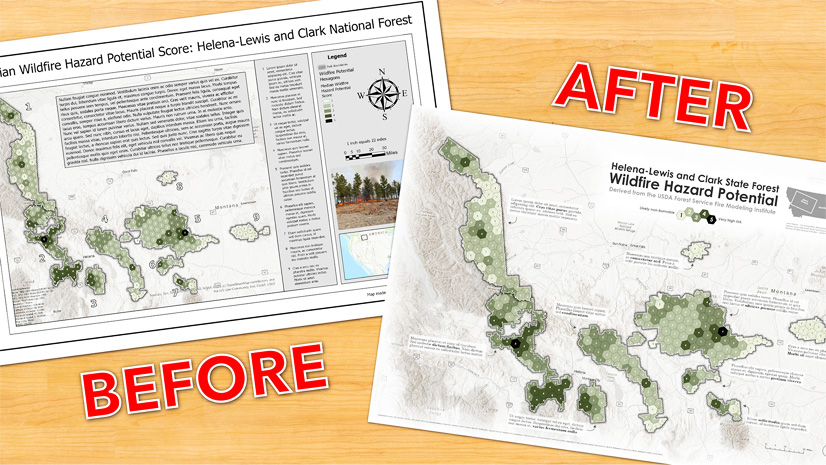
Creating custom map symbols for the Sign Management solution
Daniel Wickens | Mapping | November 26, 2023
Learn how to create your own custom map symbols for use in the Sign Management solution.
Most Recent in ArcGIS Blog
Lynne Buie | ArcGIS Pro | Nov 29, 2023
Join our free webinar on December 5th to learn how to create composite indices using ArcGIS.
Multiple Authors | ArcGIS GeoBIM | November 29, 2023
The November 2023 release extends collaboration into the field by integrating ArcGIS GeoBIM with ArcGIS Field Maps.
Multiple Authors | ArcGIS GeoBIM | November 29, 2023
With ArcGIS GeoBIM and ArcGIS Field Maps, a streamlined digital workflow replaces paper-based processes and extends BIM integration to the field.
Mark Barker | ArcGIS Drone2Map | November 28, 2023
Learn to evaluate the ArcGIS Drone2Map processing report to troubleshoot issues and achieve better processing results.
Catherine McSorley | ArcGIS Pro | November 28, 2023
New in ArcGIS Pro 3.2 - the Causal Inference Analysis tool
Vicki Lynn Cove | ArcGIS Insights | November 28, 2023
Insights 2023.3 includes a new filter widget, alluvial diagrams, and north arrows for maps.
Mark Barker | ArcGIS Drone2Map | November 28, 2023
Learn how catalog datasets in ArcGIS Drone2Map can be configured and ways they can benefit day to day workflows.
John Nelson | ArcGIS Pro | November 28, 2023
Ah, that cartographic conundrum of Siberia reaching over to peak out of the left side of a world map...
Jennifer Wrightsell-Hughes | ArcGIS Online | November 28, 2023
In a partnered collaboration, two ArcGIS Online organizations use groups and member management tools to collaboratively add and edit content.
Multiple Authors | ArcGIS Solutions | November 27, 2023
A suite of ArcGIS Solutions to support common workflows in the stormwater industry.
Chad Lopez | Site Scan for ArcGIS | November 27, 2023
This article highlights a project that used Lidar data to create a unique drone flight plan for capturing imagery at Empower Field in Denver.
Daniel Wickens | ArcGIS Solutions | November 26, 2023
Learn how to create your own custom map symbols for use in the Sign Management solution.
Dawn Wright | ArcGIS | November 22, 2023
Information about Esri's participation in the largest Earth Science meeting in the world.
John Nelson | ArcGIS Living Atlas | November 22, 2023
Imagery basemaps are lovely and provide unparalleled context. But that detail can be troublesome.
Liz Armstrong | ArcGIS Collector | November 21, 2023
ArcGIS Collector on Windows platform to retire; replaced by Field Maps on Windows 11 WSA.
Krista Carlson | ArcGIS Pro | November 21, 2023
ArcGIS Maritime 3.2 introduces new tools to streamline chart production and create depth contours, and support for PostgreSQL.
Kory Kramer | ArcGIS Pro | November 21, 2023
Contextual keyboard shortcuts open up a whole new world of customization possibilities in ArcGIS Pro 3.2.
Multiple Authors | ArcGIS Pro | November 21, 2023
ArcGIS Roads and Highways includes a variety of new and enhanced features at the ArcGIS Pro 3.2 and ArcGIS Enterprise 11.2 releases. Learn more.
Chris Delaney | ArcGIS Solutions | November 21, 2023
Updated ArcGIS Solution helps you accelerate crime reduction efforts through place-based policing.
Belle Pandya | ArcGIS Online | November 21, 2023
In this FAQs blog, I have collected the most frequently asked questions by users about Charts in Map Viewer.
Reanne Barrette | Site Scan for ArcGIS | November 21, 2023
The latest release blog shares some big enhancements such as a new processing engine, enhanced publishing capabilities, new user stories, & more.
Multiple Authors | ArcGIS Drone2Map | November 21, 2023
How to properly set up an ArcGIS Drone2Map project to ensure you are getting the most out of your RTK drone imagery.
Multiple Authors | ArcGIS Indoors | November 20, 2023
The latest release of ArcGIS Indoors includes two new offerings and highly requested features in ArcGIS Pro, ArcGIS Enterprise and ArcGIS Online.
Multiple Authors | ArcGIS Pro | November 20, 2023
With the latest release of ArcGIS Reality for ArcGIS Pro, you can use readily available satellite imagery for 3D reality mapping
Multiple Authors | ArcGIS Pro | November 20, 2023
ArcGIS Pipeline Referencing includes a variety of new and enhanced features at the ArcGIS Pro/ArcGIS Enterprise 11.2 releases. Read more.
Multiple Authors | ArcGIS Pro | November 20, 2023
The November 2023 release of ArcGIS Image Analyst for ArcGIS Pro brings exciting enhancements to deep learning, image science and SAR.