ArcGIS Online enables you to connect people, locations, and data using interactive maps. Using ArcGIS Online you can work with smart, data-driven styles and intuitive analysis tools that deliver location intelligence.
You can use ArcGIS Online as a standalone solution for your mapping and analysis needs. Or, because it’s an integral part of the ArcGIS system, you can use ArcGIS Online to extend the capabilities of ArcGIS Desktop, or ArcGIS Enterprise, or build custom apps using ArcGIS Web APIs and SDKs. ArcGIS Online also provides access to the ArcGIS Living Atlas of the World, a vast collection of curated, authoritative, ready-to-use content from Esri and the global GIS user community.
Don’t have an ArcGIS account? See Create an ArcGIS Account.
December 2019 release
ArcGIS Online is updated regularly, and this latest release adds many useful new features and enhancements. This update introduces new and improved sharing, updated settings, new organizational notices, and more. For additional details see the What’s new help topic or view all posts related to this release.
Featured in this release
Improved sharing
Sharing items in ArcGIS Online has been improved. On your content page, you can quickly see who can access your items and the groups with which they have been shared.
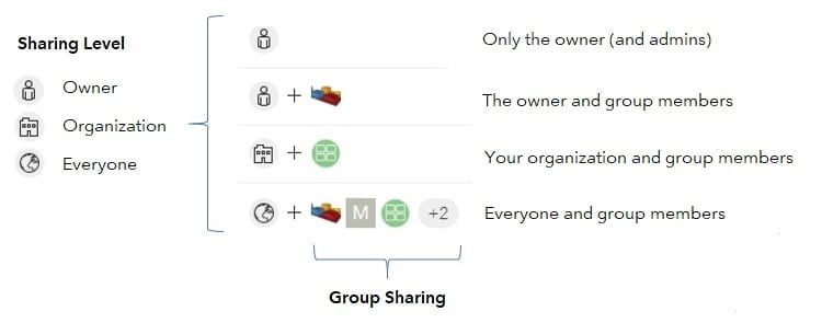
The changes enable you to clearly see sharing levels (Owner, Organization, Everyone), as well as the specific groups with which you have shared content. Group designations, such as Featured Content and Open Data groups, are also clearly identified.
For more information see What’s new in sharing items.
Updated settings
The organization settings experience has been improved with a new design, the ability to search for the setting you want, and discovery of individual settings. Administrators can more easily navigate the organization settings tab by searching for a setting, or using the side navigation links. In addition, changes are now saved automatically. For more information, see New features in organization settings.
Information banners
A new setting allows you to display custom information banners at the top and bottom of your site to inform members about your organization’s status and content. For example, you can inform members about maintenance schedules, post notices about content or projects, or deliver classified information alerts.
Access notices can be configured to display a notice of terms for users who access your site. You can specify a separate access notice for organization members, and for all users who access your site.
For more information, see New access notices and information banner.
Location tracking
Location tracking is now available as an organization-wide extension, allowing you to record where users are and where they have been. When you enable location tracking, licensed users in your organization can use the Tracker mobile app to upload their locations. The tracks are secure: users only see their own tracks unless they have permission to also view the tracks of others.
Next generation Map Viewer (beta)
The next generation Map Viewer is now available in beta. Access it from your ArcGIS Online organization through the app launcher, or when opening map or layer items.
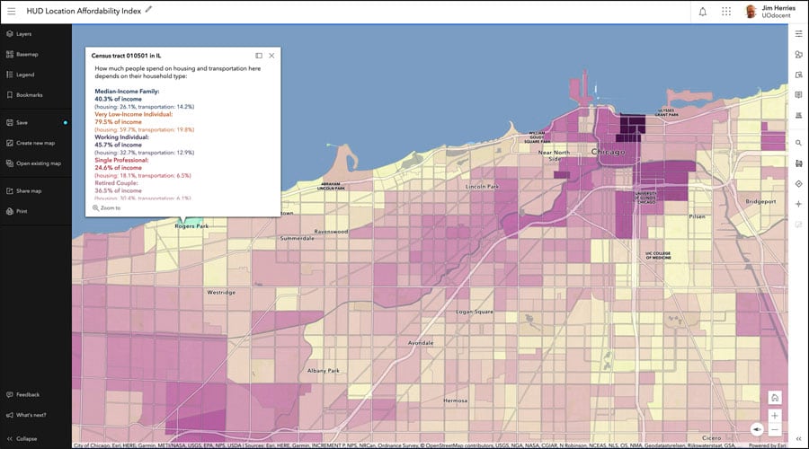
Map Viewer Beta provides an enhanced experience for key mapping workflows, and aims to inspire experimentation and creativity. It features a new design, new smart mapping styles, and fast client-side performance. For more information, see the Map Viewer Beta space on GeoNet.
Other enhancements
Mapping
Locator views have been enhanced. Organizations can now choose the type of label to use for address matching. A new locator view option allows organizations to return primary street names even when alternate names are submitted. Another option allows organizations to return locally known city names, postal city names, or matched city names. See Create a locator view for more information.
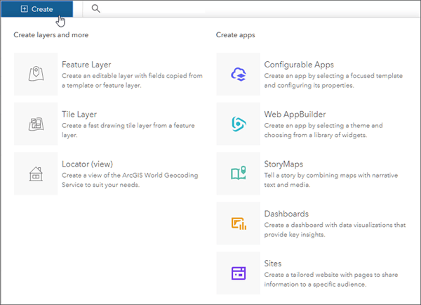
Improvements to the Create menu make it easier to create different types of content directly from the content page. New options include story maps and sites.
Data management
You can now create a map area for offline web maps that include cached ArcGIS Server image services.
When preparing web maps for offline use, you can now schedule updates for read-only clients to allow them to download prepackaged updates. Using prepackaged updates decreases the amount of time it takes these clients to obtain changes in their reference data.
Newly published hosted feature layers that you share with the public, and that are not enabled for editing or sync, now have a default cache control of 30 seconds applied to them. This setting optimizes the performance of public layers when traffic volume is high. Administrators and layer owners can increase or decrease the maximum age on the layer settings.
Administration
You can now assign credits and groups to members in bulk from the Members tab of the organization page.
Administrators in organizations using SAML-based enterprise logins can now download the ArcGIS Online service provider metadata file without having to sign in to the organization.
A new Storyteller user type will be available (January, 2020) for organization members who need to view content, such as maps, scenes, and apps, to create and share stories. Members assigned this user type can also create embedded maps using express maps when creating stories.
ArcGIS Online Security Advisor
ArcGIS Online Security Advisor allows you to obtain a full run-down of your organization’s security settings at the click of button, eliminating the need to review settings one-by-one administratively. Security Advisor also delivers recommendations based on your current settings.
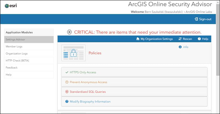
Built by the Esri Software Security and Privacy team, you can launch the app from the ArcGIS Trust Center, where you will find other useful information, alerts, and announcements. For more information see the ArcGIS Online Security Advisor story map, or visit Esri Software Security and Privacy on GeoNet.
Living Atlas
ArcGIS Living Atlas of the World is the foremost collection of geographic information from around the globe. It includes curated maps, apps, and data layers from Esri and the global GIS user community that support your work. Visit the ArcGIS Living Atlas of the World website where you can browse content, view the blog, and learn how you can contribute. Here’s what’s new, been recently released, or is coming soon.
Living Atlas Apps
Living Atlas apps leverage Living Atlas content to create interesting and useful visualization and analysis tools.
World Imagery Wayback provides a dynamic browsing and discovery experience of the World Imagery basemap archives.
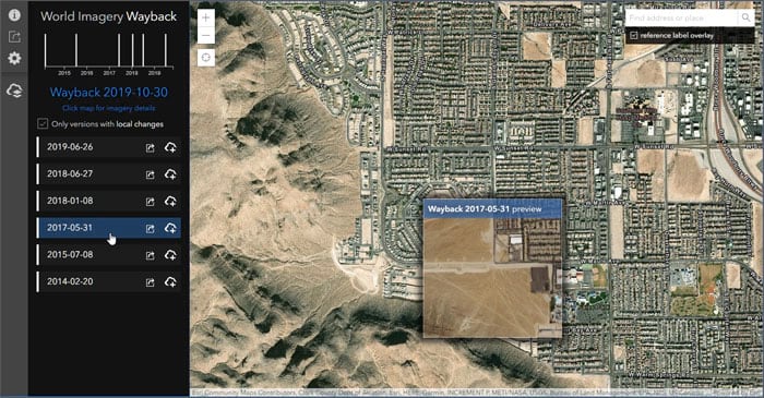
Wayback has been enhanced to include better sharing capabilities, configuration options, and an improved mobile experience. For more information, see Wayback app enhancements or view other Wayback blog articles.
Geocoding
The service has made significant improvements in the underlying data and capabilities for the following countries: Czechia, Denmark, and New Zealand.
Basemaps
The World Imagery basemap has been updated with Maxar Metro updates for 470 cities around the world. Other basemaps have been updated using HERE quarterly updates, content contributed via the Community Maps program, and OpenStreetMap refreshes. All vector basemaps are updated on a three-week cycle.
Community Maps
The Community Maps Program enables users to provide feedback, add features, and share data layers and services. Contributed content is added to Esri basemaps.
Community Maps has been recently enhanced with improved sharing workflows, map editing, and feedback, as well as more frequent basemap updates. The new Community Maps Editor group has enabled participants to add over 80 thousand unique features since January of 2019. The Basemap and Geocoding feedback group has also increased in activity, and continues to improve Esri’s suite of basemaps with over 10 thousand feedback items.
Elevation
World Elevation dynamic image service layers (Terrain and TopoBathy ) are updated with a few high resolution datasets from Austria, Spain, USGS 3DEP and NOAA NCEI. These layers are suitable for analysis and visualization. See High resolutions updates to elevation layers for more information.
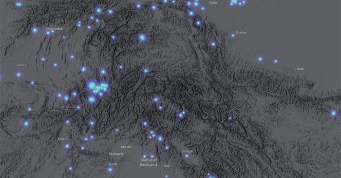
World Elevation tiled layers (World Hillshade, World Hillshade (Dark), Terrain 3D and TopoBathy 3D) are enhanced with many high resolution elevation datasets including USGS 3D Elevation Program (3DEP) at 1 m resolution, Estonia (1 m resolution), Grand Geneva (50 cm resolution), Tyrol and Carinthia, Austria (5 m resolution), and several cantons in Switzerland; and Basel-Landschaft (25 cm resolution), Solothurn (50 cm resolution), and Aargau (50 cm resolution).
Environment
Critical marine spatial planning layers have undergone maintenance that automates updating when the underlying source data is updated, changed or modified. These hosted feature services are fully functional and can be used for visualization and analysis. Updated layers include the following:
- USA Active Oil and Gas Lease Blocks
- USA OCS Lease Blocks
- USA Offshore Pipelines
- USA Official Protraction Diagrams
- USA Outer Continental Shelf Planning Areas
- USA Shipping Zones
- USA Territorial Sea Boundary
- USA Unexploded Ordnance
- USA Deepwater Ports
- USA Anchorage Areas
The Federal Emergency Management Agency (FEMA) identifies Special Flood Hazard Areas as part of the National Flood Insurance Program’s floodplain management. Esri provides an image service and a hosted feature service for both raster and vector analysis. The following FEMA flood hazard layers have been updated:
- USA Flood Hazard Areas
- USA Flood Hazard Areas (update in-progress)
The USGS National Hydrography Dataset (NHD) layers represent the water drainage network of the United States. These layers show key features of the National Hydrography Dataset Plus Version 2.1, which is a geo-spatial, hydrologic framework dataset created by the USGS and used for many types of modeling applications. NHD layers have been published in a variety of formats as follows:
- National Hydrography Dataset Plus Version 2.1 – hosted feature layer
- National Hydrography Dataset Plus Version 2.1 – vector tile layer
Other updates include:
- GEOGloWS ECMWF Streamflow System (6 Day Forecast)
This map service is designed for fast data visualization of Global Stream Flow forecast for over 1 million reaches across the globe. - Earthquakes live feeds (item page link coming soon)
This layer displays recent earthquake information from the USGS Prompt Assessment of Global Earthquakes for Response (PAGER) program. In addition to displaying earthquakes by magnitude, this service also presents earthquakes by impact. Impact is measured by population as well as models for economic and fatality loss. This layer is transitioning to hosted feature services, and will no longer require subscriber access.
Demographics
The American Community Survey (ACS) is an ongoing survey by the U.S. Census Bureau. It compiles information such as ancestry, citizenship, educational attainment, income, language proficiency, migration, disability, employment, and housing characteristics.
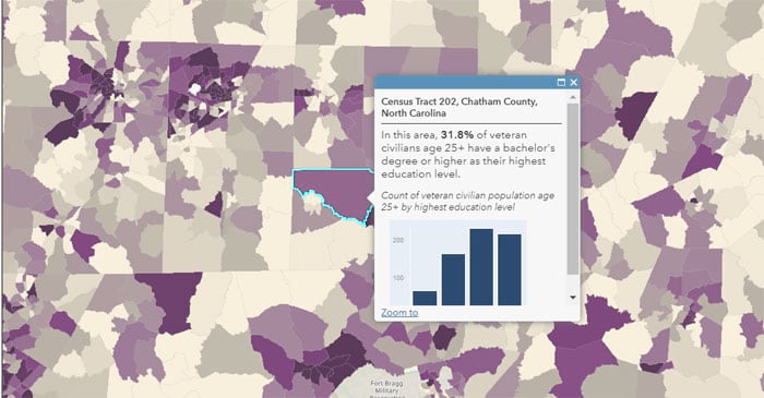
Living Atlas ACS layers will be updated with new Census data, with updates completed and available later this month. The Living Atlas ACS layers include 78 items containing the most current information, with 5-year estimates on demographic, housing, and workforce characteristics of the U.S. population. New layers include:
- ACS Education by Veteran Status (centroids and boundaries)
- ACS English Ability and Linguistic Isolation Variables (centroids and boundaries)
- ACS Labor Force Participation by Age Variables” (boundaries and centroids)
- ACS School Enrollment Variables (centroids and boundaries)
- ACS Housing Tenure by Heating Fuel Variables (centroids and boundaries)
- ACS Housing Tenure by Heating Fuel VariaACS Housing Costs by Age Variables (centroids and boundaries)
In addition to new topics, the layers also will have improved metadata in the form of long field descriptions for each attribute, providing users with definitions that are helpful when deciding which attributes are most appropriate for their needs. For more information, see Updates to American Community Survey Living Atlas layers.
Miscellaneous Living Atlas additions
Other maps and layers recently added to the Living Atlas include the following:
- HUD Fair Market Rents
- CalFire Fire Perimeters 1878 – 2018
- Monopoly Map of housing values
- Where are extreme commuters?
- Projected Population Change 2010-2023
For more information visit the ArcGIS Living Atlas website, or view the Living Atlas blog.
ArcGIS Companion
ArcGIS Companion makes it easy to use ArcGIS from your mobile device. In addition to the mobile browser option (just use your URL), you can now connect to ArcGIS using this companion mobile app for iOS and Android. Access ArcGIS anytime, anywhere, to explore content, view groups, edit your profile, and more.
ArcGIS Companion now supports switching accounts. You can add accounts from ArcGIS Online, ArcGIS Enterprise, and public accounts.
The ability for administrators to manage a member’s add-on licenses for Runtime Analysis has also been added for this release.
For more information, see What’s new in ArcGIS Companion 2.5 (December 2019).
ArcGIS Urban
ArcGIS Urban is an immersive 3D experience designed to improve urban planning and decision-making. You can visualize projects in your local context and leverage location intelligence to drive better decisions, be more proactive and less reactive in your planning process, and simplify project collaboration across internal agencies and public stakeholders.

The December release of ArcGIS Urban (1.1) adds the ability to pick from four sandbox cities to try ArcGIS Urban without having to set up or prepare any data. The new street view mode lets you explore your city from a street-level perspective, and compare future scenarios with what you see today.
ArcGIS Urban 1.1 also adds new export functionality that enables you to consume and share the content you created with ArcGIS Urban in other applications and tools. For example, you can export scenarios as web scenes to embed in story maps, or download calculated capacity indicators as spreadsheets to use in reports.
The data manager has also been improved to make it easier to import a list of zones directly from a feature layer.
For more information, see What’s New in ArcGIS Urban.
ArcGIS Hub
ArcGIS Hub is an easy-to-configure cloud platform that organizes people, data, and tools to accomplish initiatives and goals. With sites, events, configurable apps, and other solutions, ArcGIS Hub enables your team to create and share maps, apps, and initiatives that align collaborators across organizations and communities with the information and content they need to manage projects and drive desired outcomes.
ArcGIS Hub is available at two license levels: Basic and Premium. ArcGIS Hub Basic is included with ArcGIS Online and delivers data sharing and site creation capabilities, while ArcGIS Hub Premium includes additional features and capabilities for working with teams of people (including members of the community). For examples, view the ArcGIS Hub Gallery.
Recent enhancements to the ArcGIS Hub engagement platform include the following:
Using an Initiative, all relevant content related to a specific plan, project, or events campaign can be shared. With messaging for followers, email updates can be sent at any time to keep others up to date on your initiative.
ArcGIS Hub Settings, a central place for managing your ArcGIS Hub, makes it easier for administrators to configure their hub’s sign in experience. You can now add a trusted logo so community members will know they are in the right place. You can also add a community support contact and/or custom terms and conditions. Additional settings will be introduced in future releases.
Recent enhancements to Hub’s search experience include the addition of several new facets and categories that will make your content even more discoverable.
For more information see What’s new in ArcGIS Hub (December 2019). Future planned updates will include Survey 123 integration, support for multiple teams, and easier content upload.
StoryMaps
ArcGIS StoryMaps make it easy to create inspiring, immersive stories by combining text, interactive maps, and other multimedia content. Publish and share your story with your organization, or with everyone around the world.

StoryMaps continues to evolve with improvements to enhance your experience when telling stories with maps. The following new features and capabilities have been recently added.
Slideshow (beta) is a new immersive block that pairs a full-screen media panel with a movable narrative panel, enabling readers to move between slides laterally. This new block is ideal for media carousels, presentations, and more. For more information see Slideshow: A new immersive block in ArcGIS StoryMaps.
Sidecar is another immersive block that now supports embedded web content in the media panel, enabling the display of live charts, configurable apps, and other interactive elements alongside explanatory text.
For more information about these, and other enhancements, see the updated What’s new in ArcGIS StoryMaps. For additional information visit ArcGIS StoryMaps.
Classic Story Maps
Classic story maps now have an updated transition timeline. You can still use classic story map apps, view the classic story map gallery, or manage and maintain your classic story maps in My Stories.
App Builders
App builders let you easily create custom apps, no coding required, and you don’t have to be a designer, or even a map expert. App builders have been updated with the following enhancements.
AppStudio for ArcGIS
AppStudio for ArcGIS lets you turn your maps into beautiful, consumer-friendly mobile apps ready for Android, iOS, Windows, Mac OS X, and Linux. Your branded apps can be published to all popular app stores – no developer skills required. With AppStudio, organizations on the ArcGIS platform can now build cross-platform native apps easily.
In the latest release, the minimum supported Android version has been updated from 4.4 to 5.0. Improvements have been made to support IWA and PKI authentication in apps, along with better use of the device locale to improve app support for languages other than English. New samples are included for coordinate conversion, GNSS discover, and the document window.
Download AppStudio or to learn more, see Whats new in AppStudio and the AppStudio GeoNet Place.
Web AppBuilder
Web AppBuilder for ArcGIS delivers a way for you to easily create web apps that run on any device, using a gallery of ready-to-use-widgets. You can customize the look of your apps with configurable themes and can host your apps online or on your own server. Multiple widgets have been improved for this release.
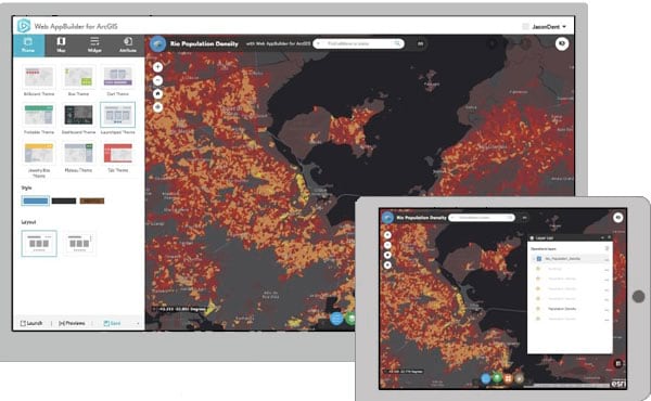
With Add Data, you can now add WFS OGC web services via a URL, or via an item referencing the service.
Group Filter allows you to add custom header text, and hide the header and filter selection if only one group is configured.
The Screening widget has new configurable options to hide rows with zero and null values in the printed report
Near Me now allows you to turn off highlighting selected features, and choose to expand or collapse filters by default when users open the widget. The filter user interface has been redesigned, making it more noticeable and user friendly.
For more information, see What’s new in Web AppBuilder for ArcGIS.
ArcGIS Experience Builder (beta)
ArcGIS Experience Builder empowers you to quickly transform your data into compelling web experiences for a variety of audiences, across browsers and all devices, with no coding required. Experience Builder provides complete control over the layout and design elements, supporting both map-centric and non map-centric apps and website development. Provided templates and widgets help you get started quickly, and can be extended with your own.
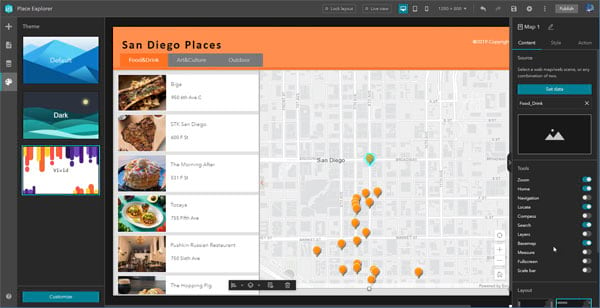
Experience Builder features both an Online Edition and a Developer Edition, and is currently in beta. Sign in to try the beta, or see ArcGIS Experience Builder to learn more.
ArcGIS Runtime
Developers use ArcGIS Runtime SDKs to add map visualization and geospatial capabilities to native apps. ArcGIS Online user types now include an explicit ArcGIS Runtime license that enables members of your organization to unlock production use of ArcGIS Runtime in custom apps at any level: Lite, Basic, Standard and Advanced.
The level of ArcGIS Runtime license included with a user type is designed to complement user type capabilities. For example, organization members assigned a Creator user type can now license ArcGIS Runtime at the Standard level. ArcGIS Runtime Standard unlocks APIs to create and edit content both online and offline, as well as access a host of local, non-proprietary data formats.
In addition, the ArcGIS Runtime Analysis extension is available as an optional add-on license for user types that include a Runtime Standard or Advanced license. The next release of ArcGIS Runtime (100.7), available later this month, will support these enhancements to Runtime licensing with user types. See Licensing your ArcGIS Runtime App.
For more information, see ArcGIS Runtime SDKs
Apps for field operations
ArcGIS apps for field operations help you use the power of location to improve coordination and achieve operational efficiencies in field workforce activities.
Tracker for ArcGIS
Know the real-time location of your most valued assets, your mobile workers. Tracker for ArcGIS is a mobile solution that enables organizations to capture the tracks of field staff, monitor where they are, and analyze where they have been. Tracker includes a mobile app for iOS and Android devices that efficiently runs in the background to capture location tracks.
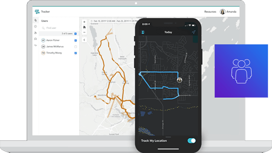
Tracker for ArcGIS is now supported in ArcGIS Online via Location Tracking. Location tracking allows organizations to see where users currently are, and to keep a record of where they have been, so their location tracks can be monitored and analyzed.
Tracker for ArcGIS includes a Track Viewer app that is used by an organization administrator to create track views, controlling who can see and use an individual’s location tracks. The Track Viewer web app enables the exploration, visualization, and interrogation of tracks by authorized viewers, typically managers or supervisors.
Tracker for ArcGIS mobile app is a lightweight native mobile app for iOS and Android devices that is optimized for tracking user locations in the background with minimal impact on battery life. The mobile worker is in full control of when they are tracked, and can set reminders to turn location tracking on and off.
Learn more about what’s new in Tracker.
Navigator for ArcGIS
Navigator for ArcGIS is a mobile navigation app for Android and iOS that enables you to route your field workforce, delivering turn-by-turn, voice-guided directions for optimized routes. It comes with hundreds of global maps, and you can also add your own custom map. You can define travel modes, route using your own roads, and search your assets.
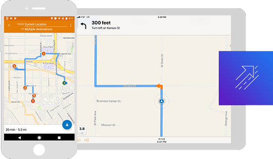
The recent release enables sharing of route layers with drivers directly in the Navigator app, providing time savings and assurance that even when connectivity is not available, access to routes will not be compromised. Also added is the ability to pause multi-stop routes without canceling routes entirely. In addition, drivers can now fully interact with features and assets on their Navigator maps and see complete attribute information, including media and attachments.
For more information, see What’s new in Navigator.
Explorer for ArcGIS
Take your maps with you everywhere you go with Explorer for ArcGIS, a mobile app for iOS and Android, and now available on Windows. Take your GIS with you in the field, work offline, and add shapes and notations directly to your map.
Previously limited to Android and iOS, Explorer is now available on Windows 10. Explorer for ArcGIS on Windows delivers new functionality, including numerous ways to work offline and use layer refresh interval settings. Raster and mosaic layers can also be directly read from a mobile map package. These updates and more will soon be available on Android and iOS.
To learn more about Explorer for Windows, see Explorer for ArcGIS brings simple map viewing to Windows.
ArcGIS QuickCapture
ArcGIS QuickCapture is the fastest way to collect field observations. With this simple app, you can quickly record field observations from vehicles, conduct aerial surveys, or assess damage. Data can be sent back to the office for analysis in real time, eliminating time spent manually processing handwritten notes. ArcGIS QuickCapture is integrated with ArcGIS, so new data from the field can be used instantly for better decision-making.
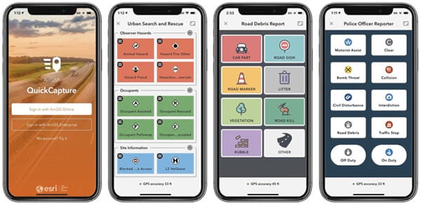
Version 1.3 lets you configure projects so end users can update the attributes of a collected record by entering free text or selecting a value from a list. ArcGIS Hub Premium users can also now share their projects publicly to support crowd-sourcing, citizen-science or community engagement initiatives.
QuickCapture is available in the Apple and Google Play app stores. You can also download the Windows version. To learn more, check out new tutorials and posts in the QuickCapture GeoNet Place, or What’s new in QuickCapture.
Survey123 for ArcGIS
Survey123 for ArcGIS is a simple and intuitive form-centric data gathering solution that makes creating, sharing, and analyzing surveys possible in just three easy steps.
In version 3.7, performance of the inbox has significantly improved, allowing you to more quickly download records onto your device. The numbers and calculator appearances have also improved, no longer invoking the device keyboard to display and better navigation between questions.
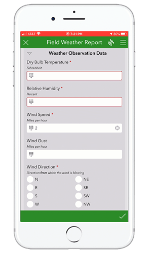
Support has also been added for the Juniper Geode external GNSS receiver.
Download Survey123 or to learn more, see Whats new in Survey123 and the Survey123 GeoNet Place.
Collector for ArcGIS
Collector for ArcGIS is a mobile data collection app that makes it easy to capture accurate data and return it to the office. Fieldworkers use web maps on mobile devices to capture and edit data. Collector for ArcGIS works even when disconnected from the Internet, and integrates seamlessly into ArcGIS.
The 20.1.0 release of Collector for iOS is scheduled for Q1 2020. This release is focused on several new capabilities, including snapping and updating multiple forms at once.
Snapping within Collector will allow you to create features that connect to each other so your edits are more accurate, with fewer errors. When snapping is turned on, the location target will jump (or snap) to vertices when placed near them, and within a certain tolerance.
By updating multiple forms at once, you can quickly edit the attributes of multiple features. Combined with another new feature, the ability to reuse recent values, Collector is minimizing repetitive data entry tasks.
See Collector for ArcGIS (iOS) updated to learn about these updates and the 19.2.0 release of Collector on iOS.
Apps for the office
ArcGIS Apps for the office enable operations managers and analysts to visualize data in a geographic context to gain location-based insights and make decisions that save money and time.
ArcGIS Insights
ArcGIS Insights fuses location analytics with open data science and business intelligence workflows. Explore data and perform spatial analysis, statistical analysis, predictive analysis, and link analysis within an intuitive experience that works the way you do.
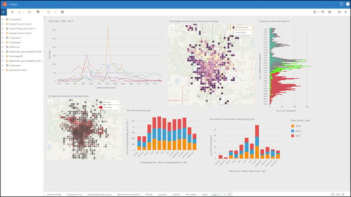
This latest release offers the following enhancements:
Coded value domains and subtypes are now supported in Insights. If your feature class or feature layer has domains and subtypes, the filters, cards, and widgets will honor the coded values, which is valuable for easily understanding how data is classified and categorized.
A new look and feel has been introduced. Page view options have been redesigned for a cleaner experience, and to increase screen real-estate. The workbook toolbar has been adjusted for simplicity.
Export data provides a one-click option to export analytical datasets directly from the data pane, making it easy to share results with others, or leverage them in other applications. Supported export formats are shapefile, CSV, or GeoJSON.
New field calculations are available for date/time fields, including TIME() and TIMEDIF().
Summary tables have been improved to make it easier to add, remove, and reorder fields.
For more information, see the ArcGIS Insights documentation.
ArcGIS Earth
Explore any part of the world with ArcGIS Earth. Work with a variety of 3D and 2D map data formats, including KML. Display data, sketch placemarks, measure distances and areas, and add annotations.
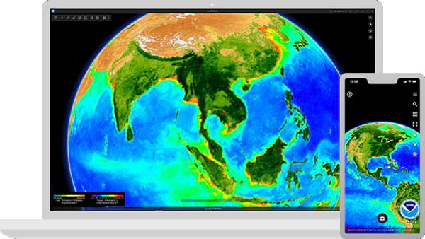
ArcGIS Earth version 1.0.1 was released on November 29th for both Android and iOS users. The release includes fixes, enhancements, and new options to add or share data.
iOS users, aside from adding data through iTunes, can now also share data among devices using AirDrop, and can download and add data from browsers, email attachments, or instant message apps, such as Messenger.
Android users can share data among Android devices via Bluetooth, and download and add data from browsers, email attachments, or instant message apps such as Messenger.
For more information see What’s new in ArcGIS Earth.
ArcGIS Business Analyst Web
ArcGIS Business Analyst Web is a web-based solution that applies GIS technology to extensive demographic, consumer spending, and business data to deliver on-demand analysis, presentation-ready reports and maps. Select from a wide variety of existing reports, or create custom reports to meet your marketing needs.
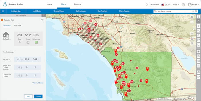
With the latest 7.4 release, ArcGIS Business Analyst Web App users can now use the Void Analysis tool to analyze hundreds of potential businesses in similar areas to find business gaps in your trade area. Void Analysis tool is a crucial feature for companies who want to explore market demands in new areas or landlords seeking to fill vacancies.
For more information, see the What’s new in ArcGIS Business Analyst Web App blog article and the Business Analyst What’s New help documentation.
ArcGIS Maps for Power BI
ArcGIS Maps for Power BI helps you unlock the power of location in your business intelligence, from inside Microsoft Power BI. Spatially enable business data, create maps to surface patterns and trends, gain context with organizational content and reference layers, and produce impactful reports.
With the December release of ArcGIS Online, ArcGIS Maps for Power BI will be managed as an add-on application. Organization administrators will need to assign an add-on app license to all Power BI users (Viewer user type or higher), in order to access the additional features of ArcGIS Maps for Power BI. This includes access to organizational content, more basemaps, more geocodes, U.S. and global demographics and infographics, and more.
For more information, see What’s new in ArcGIS Maps for Power BI.
For more information
For more information and additional details, see the What’s new help topic or view all posts related to this release.


Commenting is not enabled for this article.