Nearly 14 years later, mosaic datasets are still the best way to organize and share your imagery within your organization and with everyone. With the release of ArcGIS Pro, ArcGIS Enterprise on Kubernetes, and the exponential growth of ArcGIS system capabilities—including new imagery and remote sensing data models such as the Oriented Imagery Dataset and Trajectory Dataset—it’s time we reacquaint ourselves with this essential data model and why it should be considered for your imagery workflows and systems. Even with the inclusion of these data models, the mosaic dataset is still as relevant today for your imagery as it was when it was launched.
Mosaic datasets defined
Mosaic datasets, accessible as part of the standard ArcGIS Pro license, can be created locally within a file geodatabase and populated with your raster data. Any supported raster format can be added to a mosaic dataset, ideally with spatial coordinates. Mosaic datasets provide a flexible management capability for working with a diverse ecosystem of remote sensing and raster modalities. This includes content from local disks, network disks, and cloud-hosted data by referencing and streaming that data to your local machine.
Components of a mosaic dataset
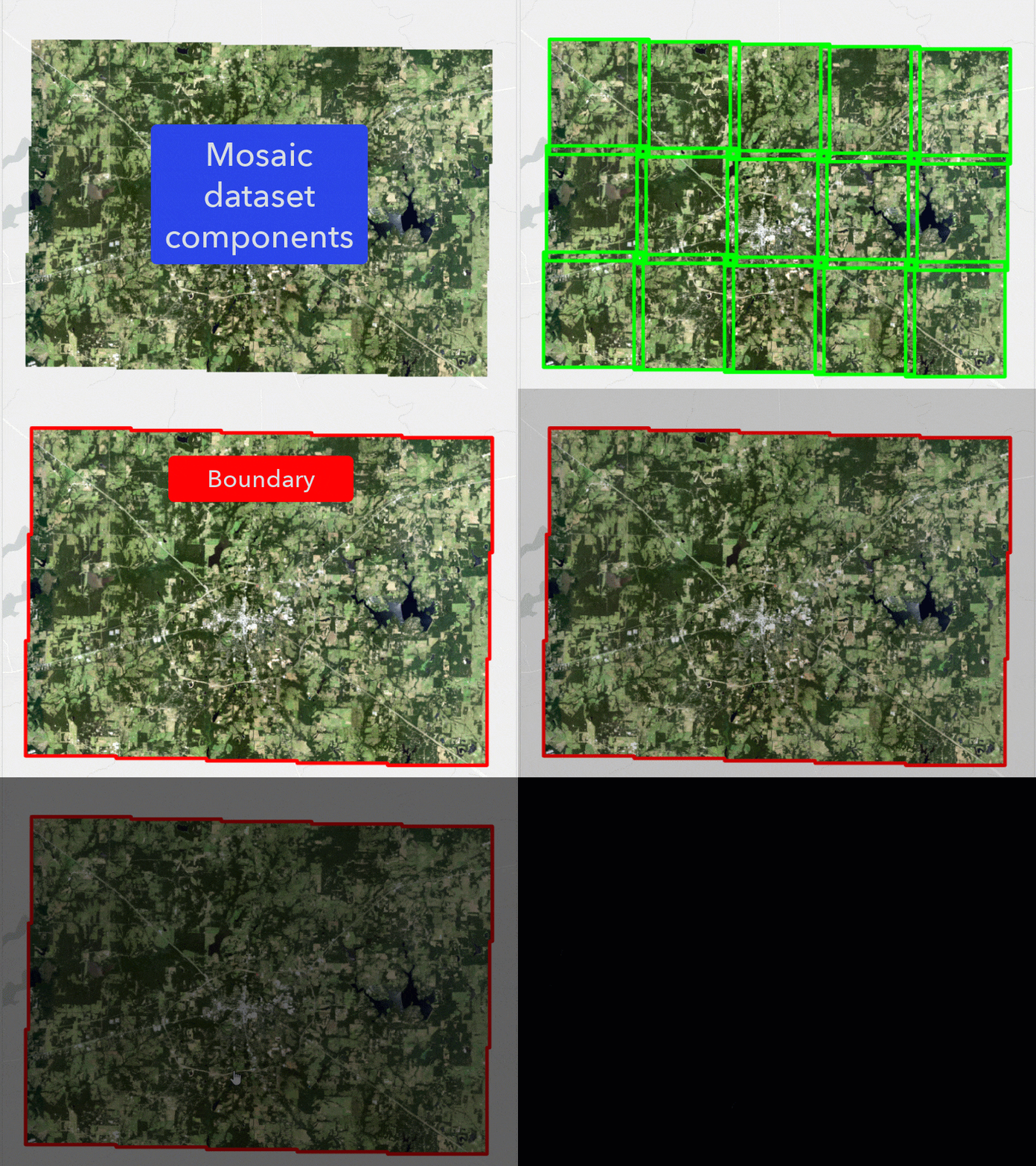
Mosaic datasets are comprised of three feature layers based on the input imagery and an image layer, rules about how those input images will be displayed, and properties of the mosaic dataset that will affect imagery extraction and mosaicking of the input images. When viewed in an ArcGIS Pro map, the two feature layer components (boundary and footprint) and the top layer of the on-the-fly mosaic (imagery layer) output will be visible by default. In the graphic below, the footprints and overviews are displayed separately, but both will appear in the same layer within the mosaic dataset.

Imagery – The imagery layer controls the visualization of visible data within the boundary layer like a single imagery layer in ArcGIS Pro. What portion of each dataset within the mosaic dataset that is visible and controllable through the imagery layer is by a combination of the sorting, overlap resolution and mosaicking rules in addition to any other visualization processes applied to the mosaic dataset such as a time filter, using date information in the footprint, and on-the-fly processes from raster functions.
Footprint – The footprint layer contains a feature for each added input image, where the spatial extent of the image is used to create the geometry of the feature. The fields in the footprint layer provide a set of attributes that affect how the input imagery will be displayed, queried and organized. These attributes can be key metadata information such as visibility based on map scale, acquisition date for a satellite sensor, climate variable for a scientific raster dataset, and sensor type used to generate a topographic surface raster.
Overviews – Using the source images or raster data, the visual display performance of the mosaic dataset can be improved through the creation of overviews. Overviews are pyramids or reduced-resolution versions of the mosaicked results of all the input images. The spatial extent of the individual overviews will extend beyond the spatial extent of individual input images. Overviews are generated at different levels based on the spatial extent of the mosaicked images.
Boundary – The boundary layer controls what is visible in the imagery layer when all the input images are mosaicked together, including source data and overview images. The output will be the merged output of all the footprint images. If you want to remove the visibility of certain portions of the imagery layer, modifying the geometry of the boundary file will control what areas are visible in the imagery layer.

Mosaic dataset advantages
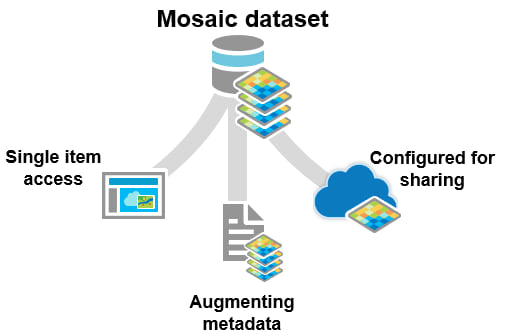
As the backbone of your imagery investment, mosaic datasets can both be a way to use imagery locally and use it to manage imagery layers that are shared. Using a mosaic dataset to organize your imagery provides a few advantages when using and maintaining your imagery. These advantages include the following:
Single item access – When added to a map in ArcGIS Pro, the mosaic dataset appears as a single item rather than all of the input images. So that when you want to use the mosaic dataset in a raster function or raster analysis tool, you can add the mosaic dataset. You can also control the visualization for the entire set of images in the Symbology pane.
Augmenting metadata – Beyond compiling, organizing, and simplifying your experience with one or more rasters, mosaic datasets also support workflows for adding more information, associating simple or complex on-the-fly preprocessing functions, serving as inputs for imagery or raster analysis tools, and even being shared to ArcGIS Online or ArcGIS Enterprise for scalable imagery visualization and analytics through the cloud.
Configured for sharing – Mosaic datasets allow you to control how overlapping imagery is used, the bit depth, number of raster bands, spatial resolution, and projection information. During the building of the mosaic dataset, you control these aspects of the mosaic dataset and can create your desired output. These defined properties will be used to define properties of the imagery layer created from the mosaic dataset. Once shared, your mosaic dataset becomes the backbone of an imagery service, providing access to the well-managed dataset created across your organization. It’s more than an organizational catalog; it’s a GIS engine fueled by your content to power your work.

Mosaic datasets in action
One of the most significant capabilities of mosaic datasets is their ability to manage your imagery content, but also other raster-based remote sensing content or scientific outputs. These datasets can be static or living datasets in which new information is continuously added. Although named for their ability to dynamically mosaic multiple overlapping datasets, mosaic datasets are equally efficient in managing datasets with the same extent and boundary. With the ability to apply and associate on-the-fly processing templates for client-side rendering and analysis, mosaic datasets simplify the management and sharing of services while maximizing the number of end datasets your users can engage with.
The power and flexibility of a mosaic dataset can be seen through the various uses of a mosaic dataset within an organization. Because it can handle any accepted raster format, the mosaic dataset can be adapted to fit into your workflow whether you need the mosaic for local organization of imagery, or to control the look and feel of your imagery layers, or a combination of both. These are just some of the uses for mosaic datasets within your workflow. They are great for managing ‘live’ or imagery layers that need to be updated and can also be used as a time series imagery layer, where you maintain multiple versions of your imagery over different time periods.

Conclusion
Given the breadth and depth of the mosaic dataset’s capabilities, more than one blog post is needed to fully explore its potential and how it integrates with and compliments the growing ArcGIS Image and ArcGIS Reality systems. With nearly a decade of existence, mosaic datasets have been implemented globally and at every scale by users eager to take the next step with their imagery content. The question you must ask yourself, reader, is whether you’re ready to start fully leveraging your imagery content for your organization. If you are, then mosaic datasets are a great way to start that process.


Hi Andrew, Many of the items seem to be inaccessible even while signed in. Would love to check out the new features.
Update: potential user error (haha)
Brian, many thanks for the comment. There were two images linked to incorrect item IDs. These have both been updated to the correct Topographic (with Contours) web map viewed with the new Map Viewer Beta. No log in required.