
It’s almost time for the Esri User Conference, and we’re excited to head back to San Diego for a week of learning, sharing, and connecting with the GIS community. If your work touches data management in any way—designing geodatabases, managing enterprise systems, editing data, supporting offline workflows, troubleshooting performance, or integrating cloud data—there will be plenty of sessions for you to add to your UC agenda.
Whether you’re new to these workflows or have been managing geospatial data for years, these sessions are a great opportunity to learn practical tips, see demos, ask questions, and hear directly from the product teams.
In this blog, we’ve pulled together the key spatial data management sessions to help you plan your week. You’ll also find supporting resources for each topic, so you can keep learning before, during, and after the conference.
Meet the team
If you’ll be attending in person, come find us at the Expo! We’ll be in the ArcGIS Enterprise area at the Geodatabases booth. Stop by to ask questions, talk through workflows, troubleshoot issues, or just say hello. We always enjoy hearing how you’re using ArcGIS and what you’re working on.
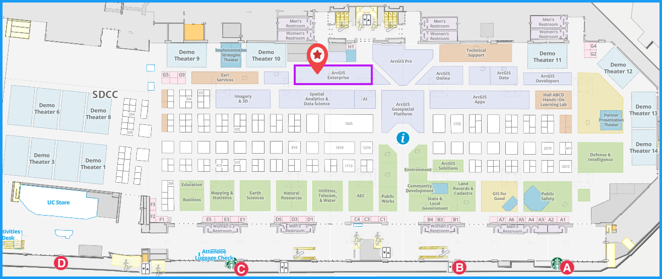
Showcase hours:
- Tuesday, July 14, 2026: 9:00 AM – 5:30 PM (PT)
- Wednesday, July 15, 2026: 9:00 AM – 5:30 PM (PT)
- Thursday, July 16, 2026: 9:00 AM – 4:00 PM (PT)
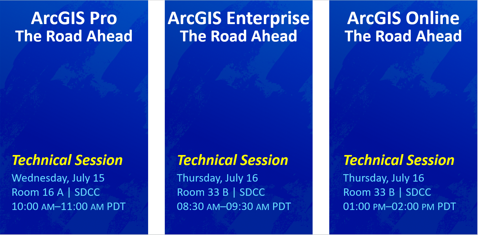
Don’t miss the Road Ahead sessions if you want a clear preview of what’s next across the ArcGIS platform. You will get an early look at in-progress capabilities planned for future releases. Together, these three sessions are a great way to plan ahead, align your workflows, and get inspired by what’s coming next.
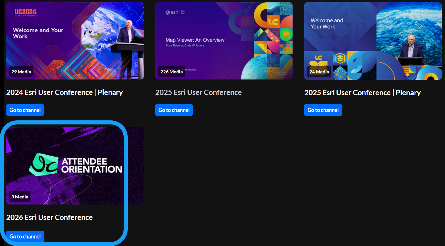
Can’t make it to every session? No problem. Many sessions are live-streamed and recorded and made available after the conference through the Esri Events platform or the Esri User Conference event page. You can also explore sessions from previous years on Esri Media Space.
Now let’s take a look at the spatial data management sessions you won’t want to miss. We grouped the sessions based on the following categories:
- Geodatabase fundamentals
- Data structure
- Data editing
- Data integration
- Data storage strategies
- Troubleshooting performance
– Geodatabase fundamentals –
If you’re looking for a solid starting point—or just want a refresher on the basics—these sessions are a great place to begin. They cover core geodatabase concepts and enterprise geodatabase fundamentals to help you better understand how to store and manage your data.
Geodatabase: An Overview

Have geodatabase questions? Learn all about this key data storage and data management framework for ArcGIS, and explore the aspects of the geodatabase information model that enhance your data with spatial and relational integrity rules, data validation, business logic, and advanced behavior.
Supporting materials:
- Getting Started with the Geodatabase – web course on Esri Academy
- Look at Mobile Geodatabases go! – An introduction – blog article
- Apply subtypes and domains to Vienna hiking trails – tutorial
- Assess urban tree health using contingent values – tutorial
- Improve campsite data quality using a relationship class – tutorial
- Create domains and contingent values from existing data – blog article
- Improve data quality with Attribute Rules – tutorial
- Use geodatabase topology for ecomobility – tutorial
- Maintain data accountability with editor tracking – blog article
- Convert a personal geodatabase in ArcGIS Pro 3.7 with a new built-in tool – blog article
Enterprise Geodatabase: An Overview

Curious about multiuser enterprise geodatabases? Join us to get an overview of multiuser enterprise geodatabases, including the basics of creating an enterprise geodatabase, loading and securing data, editing, and performing essential administration tasks.
Supporting materials:
- Deploying and Maintaining a Multiuser Geodatabase – instructor led course on Esri Academy
- Deploy an enterprise geodatabase in Oracle – blog article
- Deploy an enterprise geodatabase for real estate – tutorial
- Migrate an on-premises enterprise geodatabase in SQL Server to Azure SQL Database – Esri technical article
- Publish data from an enterprise geodatabase – tutorial
- Transfer ownership of enterprise geodatabase domains – blog article
- Restoring SQL Server databases with a new name – blog article
- Create an on-premises PostGIS only geodatabase in PostgreSQL – blog article
- Manage geodatabase upgrades in a service-based architecture – blog article
– Data structure –
Good workflows start with well-prepared data. These sessions focus on the foundational pieces that help support schema design, rule-based validation, metadata, and coordinate systems.
ArcGIS Pro: Preparing your data for the NSRS 2022 shift

The United States is currently revising its geodetic and vertical datums, as well as the State Plane system. Is your data ready for the NSRS 2022 shift? Join us to learn more about the history of the NAD83 (North American Datum of 1983) readjustments. Speakers discuss how to convert existing data in ArcGIS Pro to the latest NAD83 adjustments (2011/PA11/MA11) and how to identify incorrect NAD83 adjustments assigned to your datasets.
Supporting materials:
- What You Need to Know About the National Spatial Reference System Update – 2026 Esri UC Special Presentation
- The National Spatial Reference System Update: Insights from the Experts – 2026 Esri UC Special Presentation
- New Datums: Replacing NAVD 88 and NAD 83 – NOAA NGS website
- Prepare your data for the National Spatial Reference System modernization of 2022 in the U.S. – ArcGIS Blog article
- Coordinate Systems (Esri UC 2026) – ArcGIS StoryMap
Authoring Attribute Rules

Wishing you had an in-depth guide to attribute rules? If so, then this presentation is for you! Learn all about authoring attribute rules to enhance the editing experience and improve data quality. Starting with the basics of creating simple attribute rules using the Arcade function reference, the speakers then gradually introduce more complex Arcade expressions to develop more comprehensive attribute rules.
*This session is offered twice! You’ll have another chance to join this session on Thursday, July 16 from 4:00 PM–5:00 PM PDT in Room 30 D | SDCC.
Supporting materials:
- Attribute rules page – Geodatabase Resources Hub
- Specifying subtypes for Attribute Rules in ArcGIS Pro 3.5 – blog article
- Attribute Rules Triggering Fields in ArcGIS Pro 3.4 – blog article
- Attribute rules page – Esri Community
Coordinate Systems and Transformations: An Overview

Want a better understanding of coordinate systems and transformations? Learn about supported coordinate system types, their details, and how they are represented through well-known ID (WKID) or well-known text (WKT) in ArcGIS. When data layers use different geographic or vertical coordinate systems, you must use transformations to align the data in a map or scene. Learn how to filter the nearly 7,900 available coordinate systems to find the correct one and how to select the appropriate geographic and vertical transformation path for your project.
Supporting materials:
- Coordinate Systems (Esri UC 2026) – ArcGIS StoryMap
ArcGIS: Metadata for Sharing, Discovery, and AI Readiness

Metadata—the information about your data—is essential for content discovery, geospatial data reuse, governance, and AI readiness. Discover how metadata is managed across ArcGIS and explore strategies to simplify and unify the experience. This presentation introduces tools and workflows for creating and maintaining metadata in ArcGIS Pro, ArcGIS Enterprise, ArcGIS Online, and ArcGIS Hub. Speakers share best practices, demonstrate end-to-end workflows, and showcase metadata’s role in sharing, discovery, and AI readiness.
Supporting materials:
- Dublin Core+ Now Available in ArcGIS Pro 3.7 – blog article
- Metadata Year in Review for 2025 – blog article
- Metadata Essentials for AI-Ready GIS – Training Seminar
- Metadata, Catalogs, and Search –Esri Community
- Item Details assistant (beta) Early Adopter Community
- Metadata, Search & Discovery focused agenda
- Metadata Impact and Priorities Survey -ArcGIS Survey123 to capture requirements/feedback
Geodatabases: Generating Schema Reports

Are you looking to analyze, refine, or document your geodatabase designs? In this technical session, speakers show you how to do just that using the Generate Schema Report tool. Find out firsthand how this tool can provide a comprehensive overview of the geodatabase structure and serve as a useful data-modeling tool for identifying areas of improvement in your geodatabase design.
Supporting materials:
- Geodatabase schema reports – An introduction – blog article
- Generate a schema report in ArcGIS Pro – video
- Edit schema reports for conversion – blog article
– Data editing –
Whether you’re editing data in ArcGIS Pro, supporting multiple editors across teams, or managing sync workflows between the field and the office, these sessions have you covered. They highlight practical editing workflows in ArcGIS, from everyday editing tips and feature templates to branch versioning, feature services, and distributed data access.
Enterprise Geodatabase: Demonstrating Branch Versioning Workflows

Interested in branch versioning? This presentation explores versioning management workflows related to branch versioning using ArcGIS Pro, ArcGIS Enterprise, and the REST API. Join us to see the following workflows (and more) in action: creating and deleting versions, editing named versions, changing version ownership, reconciling, and posting versions.
* Offered twice: Tuesday, Jul 14 1:00 PM – 1:45 PM PDT Demo Expo Theater 3 | SDCC & Wednesday, Jul 15 2:30 PM – 3:15 PM PDT Demo Expo Theater 14 | SDCC
Supporting materials:
- Versioning page – Geodatabase Resources Hub
- Data Management page – Esri Community
- Version Management Service page – REST Endpoint documentation
ArcGIS Field Maps and ArcGIS Pro: Distributing Data with Feature Service Sync
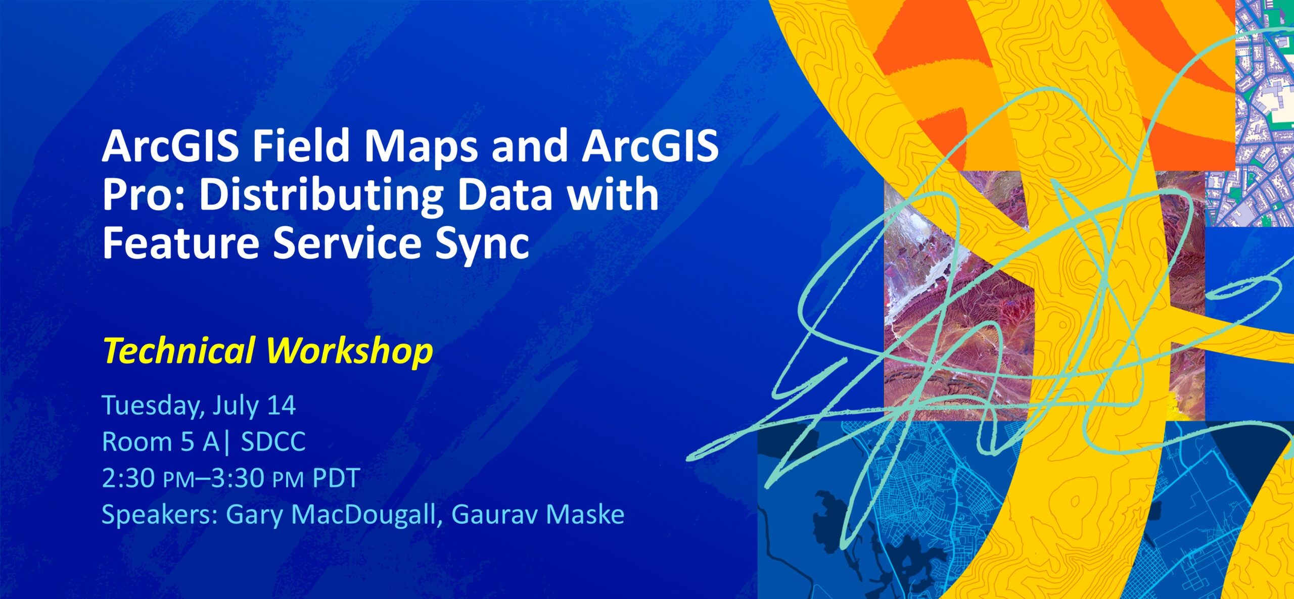
Whether you are new to distributing data or have prior experience, this presentation has something for you. Join us to discover how to use the feature service sync capability in ArcGIS and learn various data synchronization workflows using ArcGIS Field Maps and ArcGIS Pro.
Supporting materials:
- Prepare feature services for offline use – help documentation
- Work with offline maps and branch versioned data – help documentation
- Feature service sync with branch versioning – demo video
- Offline maps and traditional versioned data – help documentation
- Create replica – developer documentation
- Synchronize Replica – developer documentation
- ArcGIS Enterprise page – Esri community
- One-way feature service-to-feature service sync – blog article
- Two-way feature service-to-feature service sync – blog article
- Manage replicas in ArcGIS – blog article
ArcGIS Pro: An Editing Overview

Whether you are a seasoned ArcGIS Pro user or just getting started, editing your data is one of the most important aspects of working in ArcGIS Pro. Speakers review common editing workflows, such as creating new features using feature templates, snapping, updating attributes, and modifying existing feature geometry using various techniques and tools.
* Offered twice: Tuesday, Jul 14 1:00 PM – 2:00 PM PDT Room 10 | SDCC & Wednesday, Jul 15 10:00 AM – 11:00 AM Room 7 B | SDCC
Supporting materials:
- Trimming Roses and Editing in ArcGIS Pro –blog article
- Selection Filtering – Esri Community
- Editing tools to create multipart polygons, specifically donut polygons – Esri Community
ArcGIS Pro Editing: Tips and Tricks

Do you want to learn how to maximize the use of editing tools, templates, and guides and start using them to their fullest potential? The topics in this presentation are focused on configuring the ArcGIS Pro editing options to suit your project needs, authoring editing templates to streamline data creation, and how to set up tool options to support your workflows. Speakers discuss how to customize the UI and also provide shortcuts to help increase productivity.
Supporting materials:
- Topological editing enhancements in ArcGIS Pro – blog article
- Overview of the ArcGIS Pro Reshape editing Tool – blog article
- What’s New for Editing in ArcGIS Pro 2.9 – blog article
- Introducing editing with Inference in ArcGIS Pro – blog article
- ArcGIS Pro SDK for .NET: Editing add-in samples – Esri Community
Enterprise Geodatabase: Multiuser Editing with Feature Services

Be sure not to miss this overview of multiuser editing in enterprise geodatabases, including branch versioning and nonversioned archiving. Explore setting up data for short and long transactional editing, sharing data with the organization, and common editing workflows.
* Offered twice: Wednesday, Jul 15 4:00 PM – 5:00 PM PDT Room 4 | SDCC & Thursday, Jul 16 8:30 AM – 9:30 AM Room 10 | SDCC
Supporting materials:
- Versioning workflows page – Geodatabase Resources Hub
- Take nonversioned data offline – blog article
- Data Management page – Esri Community
ArcGIS Pro Editing: Configuring and Using Feature Templates

In this introductory presentation, speakers discuss how to configure feature templates to help increase productivity. Topics include how to set default tools and attributes for feature templates. Speakers also discuss best practices for using group and preset templates to create multiple features in a single task.
Supporting materials:
- What’s New for Editing in ArcGIS Pro 2.9 – blog article
- Attribute rules and group templates – blog article
- Introduction to feature templates – help documentation
ArcGIS Pro Editing: Managing Feature Attributes and Related Data

Want to elevate your editing game? Learn best practices for managing feature attributes and related data for new and existing features using the ArcGIS Pro editor. Speakers also discuss topics such as configuring feature templates, working with relationships, using attribute rules, and applying contingent attribute values.
* Offered twice: Wednesday, Jul 15 4:00 PM – 5:00 PM PDT Room 24 B | SDCC & Thursday, Jul 16 2:30 PM – 3:30 PM Room 30 D | SDCC
Supporting materials:
- What’s New for Editing in ArcGIS Pro 2.9 – blog article
- Transferring attributes between features – Esri community
– Data integration –
If you spend time connecting data from different systems, transforming it, preparing it for use, or thinking about where it should live, these sessions are worth a look. They highlight different ways ArcGIS supports data integration, and ETL workflows across your organization.
ArcGIS Data Pipelines: An Overview

* Offered twice: Tuesday, Jul 14 2:30 PM – 3:30 PM PDT Room 10 | SDCC & Wednesday, Jul 15 10:00 AM – 11:00 AM Room 4 | SDCC
Supporting materials:
- ArcGIS Data Pipelines – An Overview
- Introduction to ArcGIS Data Pipelines – help documentation
- ArcGIS Data Pipelines is Now Available in ArcGIS Enterprise – blog article
- What’s New in ArcGIS Data Pipelines (June 2026) – blog article
- Full-Service Real Estate Advisory Firm KBC Advisors Connects Systems and Automates Data Integration from External Systems with ArcGIS Data Pipelines – case study
- ArcGIS Data Pipelines in Action: Real-World Benefits and Tips from a GIS Professional at the City of Cambridge – blog article
- Integrate ArcGIS Data Pipelines with Microsoft Power Automate – blog article
- Join the ArcGIS Data Pipelines Community!
ArcGIS Data Interoperability: An Overview

Do you want to learn how to integrate hundreds of data formats, by import or export, and solve data quality and data engineering challenges along the way? ArcGIS Data Interoperability is Esri’s no-code extract, transform, and load (ETL) extension for ArcGIS Pro and ArcGIS Enterprise. Speakers will discuss the Workbench, Data Inspector and Quick Translate apps in the extension, plus the Quick Import and Quick Export system tools, as well as change data capture (CDC), automating metadata along with data, ETL with cloud data, and advanced topics like maintaining ArcGIS Knowledge graphs.
Supporting materials:
- ETL Patterns & Data Interoperability – Esri Community
- ArcGIS Data Interoperability – Esri community
ArcGIS Enterprise: Administration Workflows for ArcGIS Data Pipelines
Are you an ArcGIS Enterprise administrator looking to streamline complex data integration workflows? ArcGIS Data Pipelines is a no-code, visual data engineering capability that makes it easy to prepare and integrate data for mapping and analytics. This presentation outlines the requirements for installing and configuring ArcGIS Data Pipelines in ArcGIS Enterprise. Speakers also demonstrate optimization techniques using configurable server resource properties and explore strategies for scaling your Data Pipelines Server site to improve performance and automate workflows effectively.
Supporting materials:
- Install ArcGIS Data Pipelines Server using the installation guide – help documentation
- ArcGIS Data Pipelines Server system requirements – help documentation
- ArcGIS Data Pipelines Server administrator operations – help documentation
– Data storage strategies –
Where and how you store your data matters. Understanding storage approaches and tradeoffs is key to improving access, editing, validation, security, and scalability across your organization.
ArcGIS Enterprise: Data Storage Strategies

Data is an integral part of ArcGIS, providing the foundation for your mapping, analysis, and decision-making workflows. Where you store your data impacts how you access, edit, validate, secure, and scale it. This presentation highlights the storage options that are available in ArcGIS, from ArcGIS Data Store and enterprise geodatabases to cloud storage and cloud data warehouses. Get a high-level understanding of the data storage landscape in ArcGIS Enterprise and how you can use these different storage options in your own organization.
Supporting materials:
- Portal for ArcGIS: Data and publishing in ArcGIS Enterprise – help documentation
- ArcGIS Enterprise: Data Stores – help documentation
- Content management techniques for your ArcGIS Enterprise portal – Esri technical paper
- ArcGIS clients and DBMS upgrade considerations – blog article
- Manage geodatabase upgrades in a service-based architecture – blog article
- ArcGIS Enterprise: Migrate to the object store – blog article
- Ten ways to integrate data with ArcGIS Enterprise – blog article
- ArcGIS Enterprise and cloud migration – help documentation
– Troubleshooting performance –
When something isn’t working the way you expect, these are the sessions you’ll want on your schedule. They cover troubleshooting techniques, logs, and diagnostic tools that can help you better understand performance issues and keep your enterprise workflows running smoothly.
Using Logs and Diagnostic Tools to Troubleshoot Feature Services

Daunted by trying to identify the source of errors in workflows using an enterprise geodatabase and feature services? This presentation explores how to collect and analyze various logs. Gain insight into using these ArcGIS logs and DBMS (database management system) traces to troubleshoot and correct unexpected behaviors, empowering you to streamline operations and enhance system reliability.
Supporting materials:
- Set up intercept log files on a machine running ArcGIS Pro or ArcMap – Esri technical article
- Understand organization logs – help documentation
- Work with organization logs – help documentation
- Server logs codes – help documentation
- Work with server logs – help documentation
- ArcGIS Pro Diagnostic Monitor – help documentation
Enterprise Geodatabase: Performance Troubleshooting

Would exploring real-world troubleshooting cases help you uncover comparable challenges in your organizations? Explore various troubleshooting techniques for working through performance-related issues with enterprise geodatabases, maps, and feature services. Review real-world performance scenarios and how they were resolved through troubleshooting, and learn about tools that you can use to troubleshoot cases in your own organization.
- ArcGIS Pro Diagnostic Monitor – help documentation
- ArcGIS Pro Performance Assessment Tool – help documentation
- Analyze Map using ArcGIS Pro 3.7 – help documentation
- ArcGIS Enterprise observability – help documentation
- ArcGIS Enterprise observability – GitHub templates
- Configure Service Instance Settings – help documentation
- Optimizing ArcSOC Availability and Utilization – blog article
- Soccer: ArcSOC scanner utility – GitHub page
- Set up intercept log files on a machine running ArcGIS Enterprise – Esri technical article
- ArcGIS Enterprise Systems and Network Transport Time – Esri technical article
- Utility Network Properties Extractor – blog article
- Get started with EGDB Health – Esri technical article
- Introducing the GIS Enterprise Reporter – Esri technical article
- ArcGIS Monitor – product overview
We hope this helps you plan your week, find a few great sessions, and maybe even save yourself a little schedule juggling. See you at UC—and bring your questions, your curiosity, and maybe even your most stubborn data workflow. We enjoy a good challenge.





Commenting is not enabled for this article.