A Curious Intersection: Where Health Meets Location
What if I told you that the simple questions of “where?” and “why there?” could unlock the secrets to better health outcomes and more effective disease prevention strategies? Welcome to the fascinating intersection of geography and health, where the age-old saying “location, location, location” takes on life-saving significance.
This blog marks the beginning of a series, packed with insights, from the nuts and bolts of geographic information system (GIS) technology to the intricacies of spatial analysis and the power of the ArcGIS platform. With a mix of history, technology, and practical insights, I’ll uncover the vital role of GIS across the health industry. By the end, you’ll see the world—and its well-being—through a new lens.
The Enduring Link Between Place and Health
Did you know that “where” ranks as the 110th most commonly used word in the English language, with “place” coming in at 107th? This little trivia underscores a profound truth: location permeates our existence, influencing aspects of life we often take for granted, including health. The connection between location and health is as ancient as it is profound. In the fifth century BCE, Hippocrates, known as the Father of Medicine, astutely observed the impact of environmental factors on health. His treatise “On Airs, Waters, and Places” laid the groundwork for understanding that our surroundings significantly influence our well-being. Fast forward to 1854, and we find Dr. John Snow using maps to understand the cholera outbreak in London, a pioneering effort that identified contaminated water as the source of the epidemic and earned him the honorific, the Father of Modern Epidemiology. These historical milestones are not just stories from the past; they are testaments to the critical role of place in health.
The Epidemiologic Triad: A Geographic Perspective
Modern epidemiology often employs the epidemiologic triad as a way to determine the source of infectious disease, non-infectious disease, and accidents or injuries. The triad, taught to every medical and public health student, includes: an agent causing disease, a susceptible host, and an environment where they interact.

Whether the ‘agent’ is a virus like measles, the impact of extreme heat, or the forces involved in a motor vehicle accident, geography plays a crucial role in understanding these interactions by bringing together the contextual factors defining the environment. The “where” then shapes the “why” and the “how” of health outcomes across these complex systems.
Embracing the Geographic Approach
At Esri, we often speak about what we do as the “Science of Where.” And that science is relevant to health because at the heart of Health GIS is the geographic approach, a way of thinking and problem solving that’s grounded in the science of where – aka the science of geography. Understanding the geographic approach provides a critical foundation for embracing the use of GIS technology in health.
By definition, the science of geography is about the study of people, places and their interactions. In other words, you might say that geography asks and answers questions like:
- What is where?
- Why is it there?
- And why should we care?
This science gives us a means by which to study complex environments. Certainly, the interconnected network of factors related to health exemplifies this situation.

When we understand those things, using geographic location as a way to integrate and analyze data, we are enabled to see a broader, more holistic picture, essentially piecing together the puzzle of agent, host, and environment in a way that’s both comprehensible and actionable.

Why This Matters
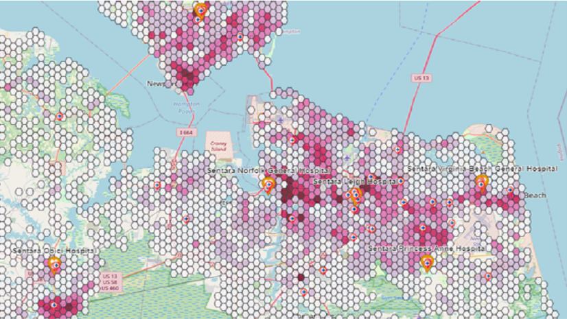
With 80-90% of data having a geographic component, the implications for health are enormous. Ignoring the spatial aspect of data is like walking through a city with a blindfold; you might get where you’re going, but you’ll miss the vibrant life around you. In a health context, you could miss the neighborhoods with unmet needs by analyzing your data with only a spreadsheet or statistical software program. You could miss the food deserts, the urban heat islands, or the transportation barriers that limit access to care. GIS technology leverages your spatial data and offers groundbreaking tools to address health challenges across the industry.

And by the way, it’s worth noting that mapped data enables an intuitive way to present and share information. People like to engage with maps, see what conditions are like in their neighborhood and the communities of their loved ones. They can quickly digest information, ground-truth the data, and begin to ask deeper questions about what’s going on where. Somehow, maps open minds to a different way of problem solving and that’s where answers often begin.
Stay Tuned: Mapping Your Way to Health
If this primer on the geographic approach to health challenges has made you eager to dive into the world of mapping, spatial analysis, and health, then please watch for my next blog which will focus on some of the quickest ways to start incorporating the geographic approach into your work with little to no experience required. I hope you’ll stay with me on the journey to explore Health GIS, where every map tells a story, and every data point can lead to a healthier tomorrow.
Follow the Health GIS 101 blog series today.