Oftentimes, data is collected in a coordinate system that isn’t suited to how you will be using it. Ensuring that the correct coordinate system is defined and a proper transformation is set is key to preventing inaccurate analysis, editing, and visualization. With 3D data, we have to consider not just the data’s horizontal (XY) coordinate system but the vertical (Z) coordinate system as well.
As 3D content has become more prevalent and more users convert their data from 2D to 3D, it’s important to understand the significance of vertical coordinate systems and how they behave throughout the Esri platform.
The vertical coordinate system defines the origin for height and depth values. Without the correct vertical coordinate system defined, you may see your data incorrectly shifted vertically, this is especially relevant when working with datasets with different vertical coordinate systems.
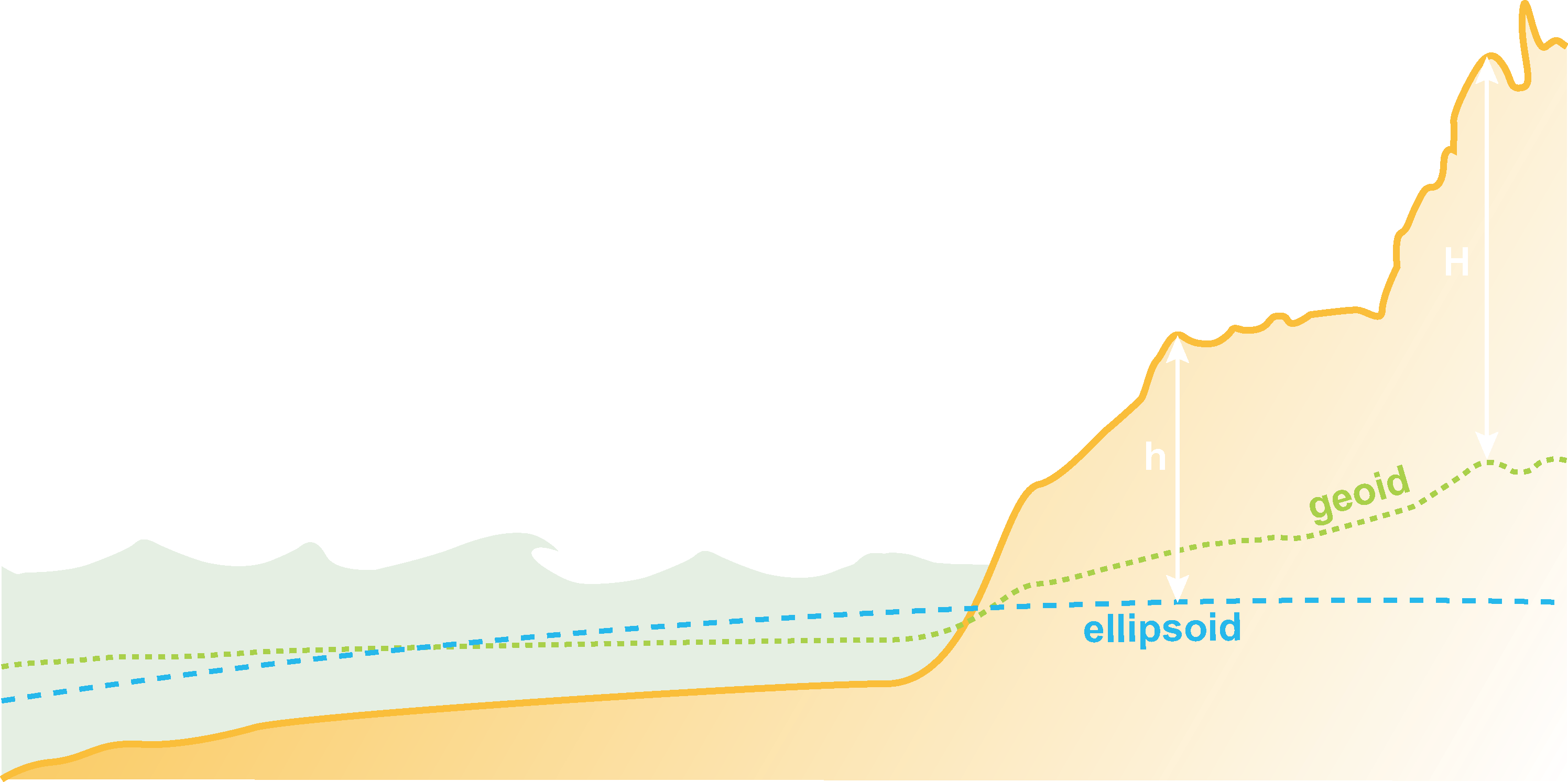
Whether you are working with an ellipsoidal or gravity-related vertical coordinate system, there are 4 main properties of a vertical coordinate system; datum or vertical datum, vertical shift, direction, and linear unit.
- The datum in an ellipsoidal VCS or vertical datum in a gravity-related VCS, is the reference point for elevation values.
- The vertical shift sets a built-in vertical offset, automatically adding or subtracting from each Z-value.
- The direction determines if z-values represent height or depth.
- The linear unit defines the unit of measurement for Z-values, generally in meters or feet.
Transformations between Vertical Coordinate Systems
Just as with horizontal coordinate systems, transformations provide accuracy when working with multiple vertical coordinate systems. But because scenes can easily switch between local and global view and global scenes support fewer vertical coordinate systems (details below), transformations may be required even when all of your data is in the same vertical coordinate system.
For example, authoring a scene in local view using the vertical coordinate system EGM 1984 (a gravity-related vertical coordinate system is not supported in global view), and switching to global view will drop the vertical coordinate system and your data will shift. Specifying a valid vertical coordinate system, such as EGM 1996 and a transformation between them will rectify the shift.
To convert from ellipsoidal to ellipsoidal vertical coordinate systems, the standard horizontal coordinate system transformations are used. To convert from ellipsoidal to gravity-related vertical coordinate systems or to go between two gravity-related vertical coordinate systems, file based VERTCON, geoid models, or equation based transformations not included by default are needed. Because of the complexity and size of these transformations, they must be installed separately – available as the ArcGIS Coordinate Systems Data installation through myesri.com. These transformations must be installed anywhere they will be used, including your server if you share web layers that require a transformation.
Although the number of transformations available continues to grow, there are far fewer transformations to go between vertical coordinate systems than for horizontal coordinate systems. In the case that there is no transformation available, the linear unit will still be converted. For example, if your data is in feet but you set your scene in ArcGIS Pro to be a VCS that uses meters, the elevation values will be converted on the fly to meters – you may still see a shift but it will not be related to a mismatch in linear unit.
Working with Vertical Coordinate Systems
There are three main places where vertical coordinate systems are used – ArcGIS Pro, the web scene viewer and web applications that consume web scenes. When 3D content, such as scene layers and elevation layers, are shared from ArcGIS Pro to be consumed in web scenes, their vertical coordinate system is maintained.
When working with vertical coordinate systems in ArcGIS Pro, there are fewer restrictions on what you can do than with web scenes and the scene viewer. The following is supported in ArcGIS Pro but not in the scene viewer and web scenes.
- You are able to have multiple vertical coordinate systems in the same scene
- A mismatch between the horizontal and vertical linear units is allowed
- Projection on the fly is supported for cached layers
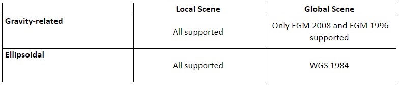
Depending on the type of scene you are working with, local or global, different vertical coordinate systems are supported. Both require that the datum of the vertical coordinate system match the datum of the horizontal coordinate system.
In ArcGIS Pro and the scene viewer, local scenes support both gravity-related and ellipsoidal vertical coordinate systems; if you don’t have a vertical coordinate system, Z values are assumed to be in the unit of your horizontal coordinate system.
For global scenes in both ArcGIS Pro and the scene viewer, the only gravity-related vertical coordinate systems supported are EGM2008 and EGM96. Additionally, all ellipsoidal vertical coordinate systems are supported in ArcGIS Pro. As of January 2018, only WGS 1984, EGM2008 and EGM96 vertical coordinate systems are supported in the global web scene viewer; if you don’t have a vertical coordinate system, Z values are assumed to be in meters.
One of the many reasons why ArcGIS Pro is so powerful is its support for vertical coordinate system transformations (i.e. projecting on the fly). You can have multiple layers with different VCS and ArcGIS Pro will properly project the data on the fly. Keep in mind that this does come at a cost for performance as the software is required to make the necessary calculations for the data to line up correctly.
For a list of supported Vertical Coordinate Systems in the web scene viewer see here
Vertical coordinate systems, just like horizontal coordinate systems, ensure the integrity of your data while editing, during visualization and analysis. Understanding how vertical coordinate systems behave throughout the Esri platform means you can be confident knowing what will happen to your data as you share and consume it in different applications. For specific, in-depth examples of working with vertical coordinate systems in local and global scenes, please see the following blogs:

Hi, cool feature. Is it possible to use the notebook as webtool within an AGOL dashboard? For example, I would like to create a more sophisticated chart in my AGOL dashboard (canned options are very lacking — can’t display standard deviation or multi paneled charts) based on data related to a spatial selection in a web map that is part of my dashboard. I am hopeful to use the plotly library (hopefully not a bad word here) to accomplish this. So, ideally, (1) I build a notebook that produces the chart I want, (2) publish the notebook as a webtool,… Read more »
Hi Thomas, Thanks for your comment! Notebook as a Web Tool is available for ArcGIS Enterprise only at the moment. We are working very hard on bringing this feature to ArcGIS Online in a future release. That said, ArcGIS Dashboards does not consume web tools and would not be able to utilize a web tool when updating charts based on selection. Currently, web tools are supported in Map Viewer Classic and ArcGIS Web AppBuilder. You can also create custom apps that execute web tools using our APIs and SDKs, such as ArcGIS API for JavaScript. Web tools will be supported… Read more »