Version 4.5 of the ArcGIS API for JavaScript adds some key capabilities and several smaller (but sweet) enhancements that will come in handy. Here are the highlights in 4.5 (as well as 3.22); a full overview detailing new features can be found in the release notes.
Fast feature layers: Interact with more than a million features
Now you can display more data and dynamically visualize features more rapidly, such as this layer with more than 1 million building footprints. This is achieved by enabling the WebGL option (beta) now available for FeatureLayers in a 2D map.

FeatureLayer will be rendered with WebGL by default in a future release.
Drawing: it’s here!
You now can enable drawing in your 4.x apps. In this initial release of sketching tools, you can sketch new geometries in a 2D map. Full support for drawing and editing will become available incrementally in future releases, which will include the following:
- Editing existing geometries
- Creating and editing new geometries including (but not limited to) multipoint geometries.
- Sketching/editing widgets
- Support for drawing in a 3D Scene
- Full editing support, including the ability to enable common geometry validation rules, such as preventing self intersecting lines.
Check out this new sketching sample and play around with the current capabilities.
OGC enhancements
WMS and WMTS layers can now be visualized in a 3D scene. Also, KML support has been added for 2D maps. Support for KML in 3D scenes will be available in a future release.
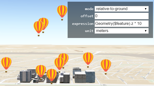
New options for vertical placement of 3D objects
The vertical placement of buildings and other 3D Objects can be set using a field value, z-value, or an expression. An example of when this would be useful is when placing objects that are either below ground or are flying above ground.
Clustering with version 3.22
If your map has a layer with a large number of points, configuring point clustering makes it easier to visually extract information from your data. When you enable clustering, point features within a certain distance are grouped into one symbol. You can enable clustering in your JavaScript app using either of the following methods:
- Apply clustering in ArcGIS Online’s Map Viewer, save your web map, and then load into your JavaScript app
- Configure clustering directly on FeatureLayers or CSVLayers in your JavaScript code.
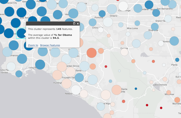
Clustering is currently only available in version 3.22, but will be added to 4.x in early 2018. This blog discusses how clustering enables data exploration.
There’s more…
Explore the release notes and new samples to learn about more updates such as support for vertical coordinate systems, pop-up improvements, and time-saving enhancements such as expanded autocasting support.
Version 4.5 release notes
Version 4.5 samples
Version 3.22 release notes
Version 3.22 samples


Commenting is not enabled for this article.