By Aileen Buckley, Esri Cartographer
 At the 2013 Esri User Conference, I demonstrated a renderer and a geoprocessing tool that could be used to make bivariate choropleth maps. In this blog post, I provide links to these resources so you can use them to make your own bivariate choropleth maps.
If you are interested, here is a link to the video (http://video.esri.com/watch/2578/making-beautiful-maps), which gives you some background information about bivariate choropleth maps and how to make them.
This is a link to a zip file with the renderer and a screenshot of how to register the dll (http://downloads.esri.com/MappingCenter2007/arcGISResources/bivariate_maps/Bivariate_Renderer.zip). This version of the renderer should work all the way back to version ArcGIS 10.0. Follow the instructions in the PDF to get started with the renderer.
This is a link to the zip file with the geoprocessing tool that classes and renders the data (http://downloads.esri.com/MappingCenter2007/arcGISResources/bivariate_maps/Bivariate_Choropleth_Map_Tools_and_Styles.zip). Note that the tool does not create the legend. This zip file also contains an .mxd and a number of style files that will help you make the missing legend. To add the legend, create it in a new data frame and position it where you wish on the page in ArcMap.
The styles in the tools and styles download also contain one set of colors for a 16 class (4 x 4) bivariate map and even one set of colors for a trivariate map. The trivariate colors came from the work of Denis White, retired cartographer from the U.S. EPA Lab in Corvallis, Oregon.
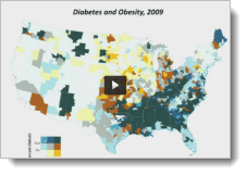
If you want, you can try these out with the data I used to make the “Diabetes and Obesity, 2009” map shown above. Here is a link to that map package: http://downloads.esri.com/MappingCenter2007/arcGISResources/bivariate_maps/Diabetes_and_Obesity_2009.zip. Note that this download is 273 MB.
Thanks to Thomas Enge, of the Esri Applications Prototype Lab (https://maps.esri.com/demo/), for his help with the renderer. Thanks to Kevin Butler, Ph.D., for his help with the geoprocessing tool. Finally, thanks to Cynthia Brewer, Ph.D., for her review of the colors in the style.

Article Discussion: